Tag Archives: South Arm

Iron Pot Lighthouse

My wonderful walk from the mouth to the source of the Derwent River seems long past, however from time to time a blog reader refers me to new information.  Thanks Mary for these leads. If you read here and here you will learn more about the history of the Iron Pot Lighthouse.

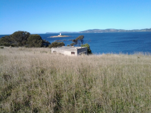
People who have read my earlier posts will know that I judged the tip of land opposite the Iron Pot to be the ‘mouth’ of the river on the northern/eastern side. I had to walk there from South Arm before my walk along the length of the river from the mouth could start. Here is one of the photos I took of the Iron Pot that day.

20140822_100305.jpg

The Iron Pot enters into the consciousness of many at this time of year.  On Boxing Day the annual Sydney to Hobart international yacht race will get underway.  After the yachts reach Tasmania and have sailed down the east coast, eventually they turn north west into Storm Bay. Not long after, the race organisers will be reporting yachts are in the vicinity of the Iron Pot. I expect the maxi yachts could start rounding the Iron Pot this Friday if they get a dream run.

If you would like to see this rocky outcrop up close without walking, take a Pennicott boat tour from Hobart (https://www.ironpotcruises.com.au/)


Another Special Anniversary

Implementation Milestone remembered:

22 August 2014 was the date when I made the first walk and commenced my long journey from the mouth of the Derwent River on the northern side, in the South Arm area.

On that first walking stage I recorded the weather as: “The sky was blue and cloudless but I was rugged up and beanied to avoid the early morning chill.” At the start of stage 2 on the 5th September the blog recorded:  “The sun is shining. Air is crisp.”  I recall that on both occasions the day warmed so the walking was very comfortable.

Nature is cheaper than therapy

A Californian fiction writer M.P. Zarrella offered the opinion ‘nature is cheaper than therapy’.  Since then, her point of view has spawned posters, cushion covers, and T shirts such as:

Nature cheaper than therapy  and tshirt nature its cheaper than therapy

The use of this comment spread until people couldn’t help themselves …

facebook cheaper than therapy and Beer is cheaper than therapy

Thinking about whether nature is cheaper (with the inference of ‘better’ than therapy), I have been inspired to trawl through my walking-the-derwent photos.

Here are a few favourite natural scenes clicked during Stages 1-6 of my walks along the eastern shore of the Derwent River.  Most of these images spent time as my computer screen background where they lifted my spirits daily.

20140822_100301

Iron Pot off the southern end of South Arm peninsula

20140822_101716

Driftwood beach shack on Pot Bay Beach, South Arm peninsula

20140822_114606

Mount Wellington across the Derwent River from South Arm Beach

20140904_110312

Looking northwards into the gigantic Derwent Harbour from Gellibrand Point at the northern end of the South Arm peninsula.

20140920_102738

Looking uphill from Trywork Point

20140926_095629

Lichen on rocks at Tranmere Point

20140926_104056

Little Howrah Beach

20140926_115158

Looking southwards along Bellerive Beach

20141010_093842

The suburb of Sandy Bay across the Derwent River through the casuarina trees from Rosny Point

20141010_123003

Tranquil Geilston Bay looking toward Mount Wellington

20141015_101248

Bedlam Walls Point

20141015_104855

Shag Bay

20141015_122048

Native flowers in the East Risdon State Reserve

20141015_133435

Tommys Bight

Whenever the weather is deteriorating outside my window, by looking at these photographs from the first 6 of 14 walking stages, I ‘revisit’ the various locations and feel most uplifted. No therapy needed here.

A tribute to the Australian men and women who fought in overseas wars hoping for a safer Australia

Today is a powerfully important day in Australia’s psyche. It is ANZAC Day; a day of remembrance and commemoration. In particular, this year’s ANZAC day represents 100 years since our defence forces arrived on the beaches at Gallipoli, Turkey near the beginning of World War 1. In 1914, an officer created the acronym ANZAC to register the coming together of two sets of national troops: the AUSTRALIAN and NEW ZEALAND ARMY CORPS. From then on and because of the actions of those men and women during the first World War, ANZAC has come to mean mateship and extraordinary personal and team efforts in the face of seemingly insurmountable odds. We talk about the ANZAC spirit.

From dawn services, to town and city parades, to commemoration services at cenotaphs, today Australians will watch, march, place floral wreaths or otherwise be involved. We will remember those who have lost their lives, been injured or otherwise involved not only in World War 1 but also in all other arenas of war where Australians have travelled to help out another country.

From the beginning of last century, most towns built cenotaphs or other memorials in prominent places. This blog, during the walk along the Derwent River, has shown photos of structures built for such commemoration purposes. It seems appropriate to reshow a selection.

On Stage 1 when walking near the mouth of the river on the eastern shore, I found the Lone Pine memorial standing proudly.  Today, ex-servicemen will gather there to remember the sacrifices of those who stormed the beaches at Gallipoli and went on to battle it out at Lone Pine. ‘Lest we forget’.

20140822_094232

The South Arm cenotaph.

20140822_112319

The Memorial Reserve at Bridgewater

20141111_131258

The Australian Tracker and War Dogs Memorial at Lowestoft Bay

20141125_150425

The Hobart City cenotaph on the Domain

20150109_161810

One war memorial, which I am yet to see, is located at Gretna a small rural town located inland from New Norfolk. The Gretna war memorial was built after World War I and sits on a hill overlooking the Derwent River. The spectacular photo below is by Lex Prebski and was taken from http://www.abc.net.au/news/2015-04-22/11-unsung-war-memorials-to-see-in-tasmania-this-anzac-weekend/6401618

Lex Prebski photo of Gretna war memorial

It is interesting that the two most special days on the Australian calender have an element of doing wrong to others: Australia Day on the 26 January celebrates settlement of Australia by foreigners and the displacement of the local indigenous peoples; and Anzac Day on 25 April commemorates the death and activity of thousands of Australian men and women fighting other nationals in wars outside Australia not of our making. The positive sides of these two days are equally clear to me: Australia Day is the chance for everyone who lives in  Australia to enjoy the fact we have a safe and friendly country; Anzac Day offers the chance to value people who had in the past or have currently, a belief and act on it hoping to make the world a safer place for everyone.

Mount Nelson Signal Station

Overlooking the centre of the city of Hobart and with a view sweeping across to the eastern shore of the Derwent River, Mount Nelson is host to a significant historical site, the Mount Nelson Signal Station.

2015-03-09 14.49.17

Wikipedia provides the information that originally this rise in the landscape was named ‘Nelson’s Hill’ after botanist David Nelson, who sailed on the ship ‘Bounty’ which visited Van Diemens Land on its way to Tahiti (the ship that was involved in the infamous Mutiny on the Bounty). In geological form, Mount Nelson amounts to not much more than a low foothill, however its name gives an indication that something grand awaits you if you venture to the top.

And such a visit is easy in a vehicle, or if you want to take an uphill walk from Hobart’s suburb of Sandy Bay.  In addition, the Mount Nelson via Dynnyrne and Tolmans Hill Metro bus service can deliver you to your destination.  If you like walking, you might choose to catch a bus to the top and then follow any one of a number of clearly marked tracks downhill. Yesterday I made a visit thanks to blog follower Je’s transport, accompanied by another follower Be who is visiting from Cairns.

From different vantage points, the spectacle of the Derwent River spread out below, made us breathless with delight. When I am walking at ground level along the Derwent River, the grand panoramas extending into the distance are denied me.  But yesterday it was exciting to see the bays and hills further afield.

2015-03-09 14.50.30

The photo above looks toward the mouth of the Derwent River on the eastern shore. South Arm peninsula can be seen extending along the water.  As  I stood on Mount Nelson I could clearly identify the Iron Pot, Fort Direction Hill, South Arm Beach, Opossum Bay and its beach, and  Gellibrand Point all of which I walked on during Stage 1 and 2 of my walk along the Derwent River.

2015-03-09 14.50.16

The photo above shows the eastern shore of the Derwent River with Gellibrand Point to the right on the northern tip of the South Arm peninsula. Then the great gaping space of Ralph’s Bay appeared straight ahead. To the left of the image, Trywork Point is in view; this was the starting point for Stage 3 of my walk (after I had walked there from the suburb of Tranmere).

2015-03-09 14.50.09

The photo above shows Ralphs Bay to the right, Trywork Point and then the suburb of Tranmere to the left – on the eastern shore of the Derwent River.

2015-03-09 14.49.55

The photo above shows the eastern shore from Tranmere on the right, through the suburbs of Howrah to Bellerive on the left – the River edges which I walked during Stages 4 and 5.

Across the parkland at the Mount Nelson Signal Station, native Wrens flitted around feeling safe as they hunted for insect meals on the ground.

I enjoyed looking at information panels on the site and learning more about how the place operated.  In addition, one panel showed the location of walking tracks.

2015-03-09 14.53.12

So … what is the history? Not long after Hobart was settled in the early 1800s, locals needed speedy and efficient communication between the convict settlement at Port Arthur and Hobart.  In addition, Hobart residents wanted foreknowledge of sailing ships approaching from the ocean through Storm Bay and on their way to the Derwent River in case any provided a threat to trade or security. To gather this information, in 1811 the Mount Nelson Signal Station was established and designed to use semaphore.  The method of communication was flags waving across the hills.  Details about the semaphore flag signalling system can be read at http://www.anbg.gov.au/flags/semaphore.html.  The site http://en.wikipedia.org/wiki/Semaphore_line provides further information. At the Mount Nelson Signal Station, flags were run up a pole – this seems a very cumbersome process compared to a person waving flags. I hope that someday the signal station will offer a demonstration to the public so I can understand the process.  Give me a re-enactment please.

This semaphore communication service continued in use until a more reliable system was available (what happened at the Signal Station on windy days, in wet weather and when clouds obscured the view?).   It was not until 1880 that a telephone line connected Hobart and Mount Nelson.

Walking around the area is free of charge.  Some pathways are provided. The site has various public amenities including picnic tables, public toilets, carpark, barbecues and a restaurant.

2015-03-09 14.50.39

For further information about eating in the heritage building pictured above, go to http://www.signalstation.com.au.  I recommend that you phone in advance if you are depending on eating there. Yesterday, despite permanent signs indicating the Brasserie was open, another sign on the building indicated it was closed.

During my visit, clouds loomed powerfully over the city and river. The day light was so bright and strong that when I turned northwards and photographed the land and riverscapes, the sky glowed white.  So I clicked a few images pointed at the sky and this silhouetted the landscape.  Using my simple mobile phone as camera, I was never able to control the light of the images.

2015-03-09 14.55.09 2015-03-09 14.55.16 2015-03-09 14.51.33 2015-03-09 14.51.23

Although these looked like rain clouds, it did not rain.  These large puffs were just passing through.

Finally I reached the mouth of the Derwent River on the western shore at Pearsons Point

The goal of walking along the western shore of the Derwent River was to reach the mouth and during Stage 13 I reached this destination marked by Pearsons Point.

Before then at 10.44am I walked past a turn off: Mt Louis Road. There was a lump up in the sky on my right.  Maybe another time it might be pleasant to see what is up there and to look at the view – which is probably a spectacular 360 degree outlook along the Derwent River, the D’entrecasteaux Channel and Bruny Island.

As I panted up the final hill, I heard the thwack of balls and realised the fencing I could see in the distance amounted to a tennis court.  A tennis court!  Ye gods! Out here in the bush and miles from anywhere?  Yes it was.  Two women were slamming the balls up and down the court.  Their two cars were the only vehicles in sight.

10.52am: I reached the Pearsons Point Reserve and was feeling rather chuffed.

20150224_105032

I wandered around the site which included a disused gun emplacement and a couple of large historic cannons.  Guess Pearsons Point would have been the first line of defence against any Russian threat (which seemed to be the main thought through the 19th century).

20150224_105306 20150224_105429

Note: the bump behind the gun emplacement and tennis court is Mt Louis. A large white edifice on the end of the Point (on the other side of the cannon) appeared to be a marine navigation beacon.

In front of me to the right hand side of the Point, the D’entrecasteaux Channel separated the mainland of Tasmania from Bruny Island (famous for its fresh produce such as cheeses, smoked fish and meats, berries, premium wines, and local oysters).

20150224_105437 20150224_105647

I was very surprised how close Bruny Island (Dennes Point) was to this part of Tasmania’s mainland.  So close.  So accessible.  And its green hills and the white sandy Jetty Beach were most attractive.

On the other side of Pearsons Point to my left, the Derwent River flowed out to Storm Bay and then onto the ocean. I could see the Iron Pot and Cape Direction at the southern tip of the South Arm peninsula on the eastern shore of the River.

I found a pleasant picnic table and at 11am ate half my lunch under a small cluster of gum trees hoping no branches would be shed on my head.  Feeling on top of the world. The sun was out and the tiniest of breezes moved through the area.  Past the trees I could see motoring boats leaving white streams behind them as they sliced through the River. I looked back northwards to the Alum Cliffs between Taroona and Kingston.

20150224_112527

With a little sadness I left Pearsons Point at 11.25am.

By 12.40pm I was passing the Hidden Cove turnoff, at 1.05pm I reached the Fossil Cove Drive junction, at 1.25pm I walked across the intersection with Treatment Plant Road, and at 1.30 I stopped for a moment at Suncoast Drive.  I looked at the one bus stop (there wasn’t a pair one either side of the road) and it did not have a timetable attached to the post, so I continued walking to Wells Parade.  I had been told this was a long road, and now I know it is.

20150224_133752

I stopped and waited for a bus which didn’t come (the first in my entire travels) and left and walked up and down and up and downhill until eventually I was back parallel to the Blackmans Bay Beach.  I sat for a while at the beach soaking in the atmosphere, smelling the salt, and relishing the fact my feet were having a rest.  When the time came (according to my bus timetable), I walked to the bus stop where I had alighted hours earlier in the morning, and before long Metro bus number 85 arrived.  After passing via the Suncoast Drive bus stop that I had looked at earlier in the afternoon on arrival back in Blackmans Bay, Maranoa Heights, other suburbs, and Kingston, I was back in Hobart city by 4pm feeling elated.  Stage 13 was over.

The land begins to open, making possible expansive views across the Derwent River.

Every so often, along Tinderbox Road, a cluster of a few properties on 5 acres or so of land each would appear after a kilometre or so of the densely bush environment.

The closer I walked to Pearsons Point the more likely that Tinderbox Road was close to the River or I could see more of the River.  Around 10.20am, while on a long and winding road (on which I considered breaking out into one of the Beatles favourite songs) which undulated so that I was walking uphill then downhill seemingly repeating this process ad nauseum, I was stopped by the beauty of a rose bush in its glorious rose hips stage. I took photographs at that point and in a number of roadside places in the following kilometres.

20150224_101936 20150224_114116

In the distance after climbing one hill, I looked back northwards to Lucas Point behind the steep rock edged bay of ‘Fishermans Haul’ (see photo below).

20150224_103427

In the photo above, the far distant hill on the left is the Alum Cliffs between Taroona and Kingston.  It gives you an idea of the distance covered in these walks.  The other land is on the eastern shore of the Derwent River.

A little further along I was looking down on a disused farmhouse at what I believe was Passage Point.  The photo below shows (green plastic protective shelters around new plants) new trees have been planted in the paddock. I saw such revegetation practices on a number of properties throughout the day.

20150224_103846

Another photo looks across the Derwent River to the southern tip of the South Arm peninsula. The glistening white buildings are those of the Fort Direction defence services complex which I passed through on Stage 1 of my walk along the Derwent River.

 20150224_105611

The Suncoast Headlands Walking Track south from Blackmans Bay

A few minutes before 8am on Stage 13, I started walking on the Suncoast Headlands Walking Track.  Initially, the track ran directly next to the Blackmans Bay Beach and then began to rise up onto the headland and continue between fenced private houses and the Derwent River. The early part of the track was directly west and so I had strong sunlight straight into my eyes, temporarily blinding me from looking at the surrounding vegetation as I walked.

Just after 8am the track turned right and I looked down into a rock edged bay.

20150224_081200

At this point the track was fenced on the River side to prevent walkers slipping over the edge of the cliff. Later on the track was fenced intermittently. I walked up and up higher onto the headland.

20150224_081454

Occasionally I passed tracks leading back into suburban streets.

At 8.13 am I caught a view of some curvy hills in the Tinderbox area headlands way in the far distance.

20150224_081802

At 8.21 am I reached a second Suncoast Headlands Walking Track sign which indicated where the path lay.

20150224_081942

However there were no clearly discernible paths across large expanses of mown grass.  I did the best I could and soon found myself at the Sewage Treatment Plant on the edge of the Derwent.  For a short while I followed a track down to the rocky shore, but at a certain point it was clear that if I reached the water level (and the descent didn’t look anything but potentially dangerous), there would be no way up on the other side of the Treatment Plant.  I retraced my steps. Then I tried to walk along the fence line in front of the Plant, but I soon found this way was impassable.  Wily blackberry canes thwarted further progress. The steep drop to the shore was frightening. And more Kookaburras were laughing. Ha. Ha. Ha. H. H. H. H. Ha. Ha.  So, again I retraced my steps and decided to walk inland along and around the Sewage Treatment Plant’s fence line. There was a semblance of a track on my new route, but obviously I had missed the main ‘thoroughfare’.

I was glad to have walked this way because, for a part of it, I enjoyed moist mosses softly cushioning each footstep.  These mosses were bright lime green in colour.  Soon afterwards, I walked across an area where tall grasses had recently been slashed making it easy to continue.  Of course I did not know where I was going track-wise so, with the sun as my guide, I simply made sure I continued southwards. Once I reached a cleared open meadow with barely visible tracks, I had warmed up, my jacket was off, and I was standing opposite the South Arm township on the eastern shore.  I walked onwards and spotted a tiny yellow sign 50 metres away. From there, at 8.40am, I crossed over the bitumen road that leads to the Sewage Treatment Plant, signed as the Blackmans Bay Wastewater Treatment Plant.

Over the road was a delightful short zig zag track down to an unnamed creek, with a small foot bridge to ensure easy access to the other side.

20150224_084156

I walked through a peaceful grove of gum and wattle trees and found, on the other side, a sign indicating I could walk left or right on a bush loop. I turned left towards the River.  When the loop turned inland away from the River I rechecked my maps and could see the track would never be near the River. I made the decision to retrace my steps and began to continue inland with the intention of reaching Tinderbox Road.

I walked on a gravel track next to the creek until I reached a most unexpected site: a very large area fenced in and designated as a Dog Exercise Area. This is set up with tyres for dogs to jump through, and rows of poles that dogs can practice some sort of slalom around. As I walked past, a massive mowing tractor-like piece of equipment rumbled up and down the large paddock shaving the grass.

20150224_085455

Blackberries galore, waiting to be picked for the pies, lined the creek side of the track next to the Dog Exercise Area.

A few minutes before 9am, I turned left onto the bitumen road that went downhill to the Sewage Treatment Plant and uphill to Tinderbox Road. On the uphill trek I walked between the dense bush and flitting bush birds while listening to their bush songs: Tweets, Chirps, Squeaks and Warbles.

The day was perfect for walking so I began to wonder whether I should aim for the mouth of the Derwent River at Pearsons Point, rather than Fossil Cove many kilometres before the final headland.  As I continued up Treatment Plant Road, and past the Blackmans Bay Scouting Camp buildings (for Joeys, Cubs, Scouts and Venturers) the temptation to head to the mouth strengthened. I reasoned that the day was young, the weather wasn’t too hot or cold and it wasn’t raining, and my feet hadn’t failed me.

At Tinderbox Road I turned left a few minutes after 9am, with the resolve to reach Pearsons Point.

Starting out from Blackmans Bay on Stage 13

Once I was off the bus at Blackmans Bay, the Kookaburras started laughing at me  (again like at the beginning of Stage 12). Ha. Ha. Ha. H.H.H. Ha. Ha. Haa. Was this an omen that I was about to do something foolish? My goal for Stage 13 was to walk to Fossil Cove, and then walk another day for a final stage to the mouth of the Derwent River at Pearson’s Point. If you have already read my posting on the 25 February then you know I reached Pearson’s Point.  Future postings will give more details about this change of mind and destination.

As I turned left from Wells Parade into Hazell St towards the Blackmans Bay Beach, a screech of Sulphur-Crested Cockatoos circled overhead. I was on the beach at 7.45am. The water was calm and I looked over the Derwent River towards South Arm beach on the eastern shore.  The Iron Pot lighthouse on the rocky outcrop just offshore from Cape Direction, on the southern tip of the South Arm peninsula, seemed to stand up from the water like a fat thumb.  Back at Blackmans Bay Beach, the fresh sunny morning was complete with power walkers and dogs leading their owners on a walk. Public toilets are located half way along the Blackmans Bay Beach.  These are the last public toilets for anyone walking further south.

How fortunate Tasmanians are to have morning views along beaches such as that at Blackmans Bay.

20150224_074639

I turned southwards and at 7.51am had reached a tiny yellow sign on a post indicating the Suncoast Headlands Walking Track was ahead. A few minutes later I reached the main sign.

20150224_075230

This sign was accompanied by another nearby.

20150224_075213

I followed the good wide dirt track and initially thought how easy it would be for Mums with prams or people in wheelchairs to follow this path. But not so. Not much further along, I needed to climb rough dirt and log stairs and I encountered such interruptions to a smooth walk a number of times.  There were occasional splits in the track without signage, so it is possible to walk a little way off the main track before you realise what is happening.

How gorgeous the morning was.  For example, the photo below is looking back to Blackmans Bay Beach.

20150224_075545

In the photo below, the rocky outcrop at the far end of the beach is where the Blackmans Bay Blowhole is located (my Stage 12 walk there was described in Nudging my way into Blackmans Bay on Stage 12 of my walk along the Derwent River).

20150224_075925

A new milestone marking the 13th stage of my walk along the Derwent River: I reached the mouth on the western shore. Whoppee Doo!!

Yesterday, I completed the first part of my walk along the Derwent River: an exciting achievement.

Last August I started walking from the mouth of the River at Cape Direction on the tip of the South Arm peninsula and now, at the end of February, I have completed the distance from that mouth to the Bridgewater Bridge and back on the western shore to Pearson’s Point near the settlement of Tinderbox.

On the 8th stage mid-November, I had the first major milestone when I finished the walk from Cape Direction to the Bridgewater Bridge. This 13th stage was the culmination of walks from the Bridge back to the mouth on the western side of the River.

During yesterday’s walk, I covered about 5km of the length of the Derwent River.  By my reckoning, the total distance of the Derwent River on the western shore from the Bridgewater Bridge to the mouth is 38 3/4 km.

For Stage 13 yesterday, I needed to walk to Pearson’s Point from the bus stop where I finished on Stage 12 and then, on reaching my goal, I needed to retrace my steps back to Blackmans Bay to connect with a bus that could return me to Hobart.  This distance was approximately 17 kms. I have now walked at least 171km not counting getting to and from buses.  But when the walks are staggered over time, this number does not mean much.

The highlights of the walk to Pearson’s Point were mostly small and natural: rosehips, green rosellas, hum of bees, resting sheep, and the taste of delicious ripe blackberries along the way.

20150224_103540

I was surprised how close the northern part of Bruny Island was to the mainland of Tasmania (almost felt like I could swim across the D’entrecasteaux Channel) and I felt overwhelmed by the staggeringly expansive and grand views across and up and down the Derwent River.

20150224_114137

The fun part was singing (including mixing up the words in my excitement) Handel’s Hallelujah chorus (from The Messiah) at the top of my voice when I passed a large sign with the words SING. You can listen to a superb version performed in 2012 by the Royal Choral Society at the Royal Albert Hall in London England at https://www.youtube.com/watch?v=IUZEtVbJT5c

https://www.youtube.com/watch?v=IUZEtVbJT5c

Over the next few days I will write up the journey and the discoveries of Stage 13’s walk.  Then I will be looking towards a long main road walk from the Bridgewater Bridge at Granton to New Norfolk which I expect to undertake in the next couple of weeks.  Once I have reached New Norfolk I will be on the way to Lake St Clair, the source of the Derwent River.

Wandella Avenue to the Shot Tower, Tasmania

My previous posting explained that the first part of my Stage 12 walk along the Derwent River took me to Wandella Ave but then I retraced some steps and took an Alum Cliff-side disused track, which ultimately resulted in my returning to Wandella Avenue.

So – when you walk from Hinsby Beach and the track arrives at Wandella Ave, turn left, walk for a short while and then turn right into Baringa Rd (the signpost for this is missing). Continue walking around and uphill until you reach the junction with the Channel Highway. I reached there at 9.44am

Nearby was bus stop 32.

I enjoyed soaking in the view across the Derwent River where I could see Gellibrand Point and Opossum Bay.

20150202_094257

Further down the River, South Arm and Fort Direction Hill were visible at the mouth of the Derwent on the eastern shore.

20150202_094443

I turned left onto the Channel Highway (which has no footpath) and was able, for some metres, to walk inside a guard rail and then later on a narrow gravel verge with traffic streaming by.  At 9.50 am I was passing the sign indicating this was the Huon Trail Touring Route.

In the bush which I had clambered through earlier and now as I walked along the road, I was concerned to see an exotic which has escaped and been self-seeding rapidly everywhere.  I don’t know the name of the plant but from experience in my own garden, I know it grows fast and furiously into a medium sized plant with a purple pea flower. I did pull out some of the smaller plants and with the moist soil the roots came out as well.  But there were thousands of plants and continuing my walk was the greater priority, so I stopped pulling.

Further up the road, I could see the top of the Shot Tower above the trees.

20150202_095550

Before long I was standing outside the Shot Tower complex. The time was 10.05am.

20150202_095803 20150202_095850 20150202_095810 20150202_095929

The person manning the souvenir shop and entrance to the Tower gave me a booklet with all the tracks and walks in the Kingborough area, and he pointed out a nearby gum tree just over a rise. ‘That’s where the Alum Cliffs track starts’, he told me. He felt sure the Kingborough Council were ready to build the final part of the Alum Cliffs track from the Shot Tower to Hinsby Beach so I guess we wait and see what progress is made in the months to come.  However, it does seem the track won’t be marked out close to the Cliff edges on that northern part.

On my list of things to do in the future will be to return to the Shot Tower to take the walk up the many stairs and look out over where I have walked. The cost is only $8 including the opportunity to watch an interpretative DVD. The Shot Tower site includes a shop, museum, carpark and public toilets.  Plus the fabulous view!

From Hinsby Beach to Blackmans Bay accomplished on Stage 12 yesterday

The goal of my walk along the Derwent River for Stage 12 was to start at my last stopping point, Bus Stop 30 on the Channel Highway at Taroona on the western shore of the Derwent River, and continue to Blackmans Bay in the local government area of Kingborough.  I did not get as far as expected, but I was satisfied when I finished 2/3 of the way along the Blackman’s Bay Beach.

Over future posts, I will write up the stories of the walk, what I saw and what I experienced, but for now it’s enough to say that I am continuing with this massive project to walk both sides of the Derwent between the mouth and Bridgewater, and then onwards to Lake St Clair.

Yesterday I covered 5 ¾ kilometres of the length of the Derwent River on the western shore (making 35 3/4 kms in total on the western shore), and walked approximately 11 kilometres (making a total of 154 kms to date) to achieve that distance; there were a lot of steep ascents and descents.

20150202_085332

This distance also takes in the streets and paths on which I walked that led to dead ends so that I needed to retrace my footsteps.

The highlights of the walk include finding a way through some of the early part of the almost untracked Alum Cliffs, the delightful walk along the tracked part of the Alum Cliffs, meeting some friendly people along the way, the unusual snake sign at Tyndall Beach, stopping for a long cup of tea in Kingston with a friend, my discovery of another tucked away beach – Boronia Beach, and the Blackmans Bay Blowhole.

There are many memorable images but my favourite for today is one of my photos of mussels growing on the rocks at Boronia Beach.  I have already made it my desktop background image. When enlarged, the blues glow.

20150202_142540

Fundamentally the Stage 12 walk was about forest and water.

20150202_113014 20150202_104740  20150202_115156 20150202_152557

The day started with my being roughly opposite Gellibrand Point at the northern tip of South Arm and finishing opposite the long South Arm Beach.

I intend my next walk will start from where I left off at Blackmans Bay and then continue into the Tinderbox area to Fossil Cove.  But before then I need to record the details of yesterday’s walk.  So Stage 13 will be a while away.

Blinking Billy Point, Lower Sandy Bay next to the Derwent River

Continuing Stage 11 of my walk along the Derwent River, I walked the foreshore from Long Beach towards Blinking Billy Point. Looking northwards, the crescent of Long Beach stretched before me.

20150119_100336

I passed a new set of public toilets around 10am and ten minutes later I was walking around Blinking Billy Point.

20150119_101600

This was an area to which Charles Darwin (http://www.biography.com/people/charles-darwin-9266433) walked from Sullivans Cove (my starting point for this Stage of the walk) in February 1836. The area’s local government has remembered the occasion with an information plaque.

20150119_101336

Out in the water is a marker for water craft: the John Garrow Light (established in 1953).  I have known this was a marker used in the Sydney to Hobart Yacht race but I had never known where it was located.  Now I know: almost east of the Blinking Billy old lighthouse.  According to http://www.maritimetas.org/sites/all/files/maritime/nautical_news_winter_2002.pdf, John Garrow was a Sandy Bay pastry-cook, who lived in Bath St. Battery Point and died 1924. This begs the question – how did a nautical navigation tool come to be named after someone that seemingly had no connection with the Derwent?

I noticed that the Point has old defence structures embedded in the cliff. I learned that these were an adjunct to the huge hill behind with the remnants of the 19th century Alexandra Battery.

20150119_100941

20150119_101150  20150119_101159

Looking down the Derwent River through the glitter of the distance to the eastern shore, I could pick out Trywork Point (the southernmost tip of land before Ralphs Bay begins) and Gellibrand Point (the northern most point of the South Arm peninsula) both providing the ‘gateposts’ to Ralphs Bay. Previously, I explored these distant Points on Stage 2 and 3 of my walk.

20150119_100933

Then I looked back to Long Beach from Blinking Billy Point with Mount Wellington in the distance. How peaceful the world seemed.

20150119_100704

Despite the promises of a short beach in Geography Bay after the Blinking Billy Point, I knew better than to have expectations that continuing my walk on the foreshore was possible. The Sandy Bay Foreshore Track finishes at Blinking Billy Point.

20150119_101600

Some years ago a friend and I tried to walk the rocky shore southwards from Blinking Billy Point but, as the tide came in, there came a moment when we couldn’t move forward or backwards.  I remembered we scrambled up through someone’s property; the people were not at home and we let ourselves out onto the street hoping no alarm systems would be alerted. We were lucky that day.

Based on that memory, I knew it was not worth proceeding any further and retraced my steps around Blinking Billy Point until I could walk up to Sandy Bay Road.

Yesterday I walked Stage 11 from Hunter St in Hobart city to Hinsby Beach south of Taroona

The goal of my walk along the Derwent River for Stage 11 was to start at my last stopping point, Hunter St at the wharf in Hobart on the western shore of the Derwent River, and continue to Kingston in the local government area of Kingborough.  But I did not get that far.  My feet said enough was enough once I found the delightful and almost hidden Hinsby Beach.

20150119_131327

Over future posts, I will write up the stories of the walk, what I saw and what I experienced, but for now it’s enough to say that I am continuing with this massive project to walk both sides of the Derwent between the mouth and Bridgewater, and then onwards to Lake St Clair.

The day was sunny with a bright blue sky, Mount Wellington was clear, and a cool breeze featured through much of the day – making it perfect walking weather.

Yesterday I covered 8 kilometres of the length of the Derwent River on the western shore (making 30 kms in total on the western shore), and walked approximately 13kilometres (making a total of 143 kms to date) to achieve that distance. This distance also takes in the streets and paths on which I walked that led to dead ends so that I needed to retrace my footsteps.

The highlights of the walk include discovering the road next to Taroona High School is a public access route which took me down to the Derwent River to a row of colourful boathouses, getting off the main road at places like Cartwright Park Reserve, and seeing the Alum Cliffs in all their majesty.  My next walk will start along the top of these.

20150119_125317

It was a revelation to watch the eastern shore and to see the suburbs and beaches on which I walked in the early stages of my walk. The day started with my being roughly opposite Bellerive and finished with my being opposite Gellibrand Point at the northern tip of South Arm.  The photo below, taken from Hinsby Beach, looks across the Derwent River to Opossum Bay Beach.

20150119_131757

I intend my next walk will start from Hinsby Beach and continue to Blackmans Bay.  But before then I need to record the details of yesterday’s walk.  So my walk for Stage 12 could be a week or more away.

A surprising connection, with an earlier stage of my walk, was discovered unexpectedly

On Stage 2 of my walk along the Derwent River, I hunted for and located on the South Arm peninsula the burial vault of William Gellibrand, one of Van Diemens Land’s first settlers in the early 1800s.  Readers of my blog may recall photos such as:

20140904_104548

After William Gellibrand’s residency, the land at that northern end of the peninsula was named Gellibrand Point. The photo below looks down onto Gellibrand Point.

20140904_111429

This evening I went to a music concert in a church with a powerful and large pipe organ.  While sitting floating in and out of absorption in the romantic organ music, I cast my eyes around the old church. My eyes passed languidly over a plaque attached high on a wall, then swivelled back in surprise. This was William Gellibrand’s white marble memorial plaque.  After the concert I took a closer look.

William Gellibrand burial plaque2

When I read that the plaque came from the Chapel, I wondered which Chapel. The internet has given me the answer.

The short story is that the Chapel was built on the Brisbane and Elizabeth St corner site of Hobart in the 1832, Gellibrand died in 1840 and a memorial plaque was installed in the Chapel. When the new church was built in 1872, the plaque was relocated. Seven years later the organ was installed and since then it has been rebuilt a couple of times. Tonight, the audience of pipe organ devotees were presented with a concert of examples of the work of Moeran, Darke, Lemmens, Delius, Manet and Andriessen.

From the website: https://fergusonandurie.wordpress.com/2012/03/02/26-07-1872-memorial-uniting-congregational-church-elizabeth-and-brisbane-streets-hobart-tasmania-2,  I learned that the current “church was to be known as the ‘Memorial Congregational Church’ in memory of the first Independent or Congregational minister, the Reverend Frederick Miller who arrived in Van Diemens Land in 1830. The very first chapel on the site was funded solely by him at a cost of £500 and opened on the 20th April 1832.”

The website also explained that “The foundation stone of the Memorial Independent Church was laid on the corner of Elizabeth and Brisbane streets in Hobart on the 16th August 1870 and was formally opened on Thursday 7th November 1872. In late July 1872 the stained glass windows for the church arrived from the Ferguson, Urie, and Lyon stained glass company of Melbourne and were promptly erected.”  You can see, on this website, photographs of the colourful glass windows.

A document located at http://www.ohta.org.au/gaz/GAZETTEER-OF-TASMANIAN-PIPE-ORGANSOctober2007.pdf provided the following information about the pipe organ: “MEMORIAL UNITING (CONGREGATIONAL) CHURCH, Brisbane Street. B. 1879 George Fincham; reb. 1936 & enl. 1939 Geo. Fincham & Sons (addition of choir organ). Reb. 1992 Gibbs & Thomson.“

It seems there have been many variations in the church’s name.  Currently this church is known as The Korean Full Gospel Church. The hospitality shown by the Korean pastor, his wife and other Koreans was exceptionally friendly and generous and so I had a rich experience with unexpected findings.