Tag Archives: Lake St Clair

The Fall of the Derwent

Early during my walk along Tasmania’s Derwent River from the mouth to the source, I was travelling near Repulse Dam on a reconnaissance trip when I came across two others.  It was a strange experience.  Previously I had become aware that two women planned, with assistance and support from others, and with the direct engagement of specific groups of people in some parts, to walk from the mouth to the source.  That day, as Andrew and I drove around for me to suss the landscape and the walking route options, when I saw two women seeming to do the same, we stopped them and I asked questions.  ‘Yes we are those women’, said Justy Phillips and Margaret Woodward.  I am sure they were as surprised as I was.

Since then, Justy and Margaret have made their way alongside various parts of Tasmania’s Derwent River and arrived at Lake St Clair where they were Facebooked taking a dip in those cold waters, seemingly delighted with their arrival.

Their project was very different from mine.  In my case, I wanted to walk around the whole of the Greater Hobart Area, and then to walk every metre of the way to the source at St Clair Lagoon dam.   By contrast, Justy and Margaret walked alongside parts of two Derwent Rivers; Tasmania’s Derwent River and the other in Cumbria England.  The experience of and learnings from their walks were used as part of the basis to write what they describe as a ‘fictionella’; written in the form of text artwork, similar in appearance to poetry.

That book is titled Fall of the Derwent. In this website you can see  range of photographs including two where Justy and Margaret are holding their black covered book.

Cover of book.jpg

The title of the book references a drawing by an early Tasmanian surveyor George Frankland which he named ‘Fall of the Derwent’.  Colonial artist Thomas Bock engraved the image and James Ross printed the picture in The Hobart Town Almanac in 1830. The picture was drawn at a site near unpassable rapids on the Derwent River upriver from New Norfolk.  When Justy and Margaret walked past what they believed was that place, they took a suite of black and white photographs;  half a dozen or so of these images are bound into their book.  Without returning to that area I seem to remember the spot.  After reviewing my photographs in that area, clearly I was looking for serenity and simplicity.  I was looking at colours and contrasts.  It seems I was focusing on one way of seeing that world of the Derwent River, and Justy and Margaret’s view is an alternative.20150917_094036.jpg
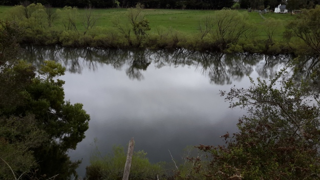
20150917_095352.jpgI did not focus on the twisted interlacing of stark and scrappy vegetation at the river edge like Justy and Margaret have done  The differences in our images is a reflection on the different nature of our projects. I wanted to entice others to be seduced by the beauty of the landscape and then to make their own journeys along the river edge (I now wonder why I didn’t see vegetation tangles as beautiful).  When I read their book it seemed they wanted to use their experiences as the basis for creative abstract thoughts; perhaps even a metaphysical approach involving questions such what is there in that world and what is it like at a more profound level.  My approach was literal and descriptive.

The Phillips/Woodward Fall of the Derwent publication presents poetry-styled ideas and comments in ‘chapters’ headed by the days of the week; the book proceeds over  44 days consecutive days – but the ideas associated with both rivers are intermixed.

“Let us begin with two rivers / And a Dad not long for living. / Two daughters …”

Despite the introductory lines, theirs is not a chronological story connecting the sequences of walking the two rivers; reference is made to other locations such as Cape Barren Island, Dover Point, and Brisbane. And the English father walked with Justy and Margaret when they traipsed near the Cumbrian Derwent. As an intertwined overlay in this book, mention is made of his declining health – Dad in pain, no longer able to feed himself, no longer speaking.  For this reason and for the manner of writing which removes easily identifiable meaning through much of the publication, this book has a limited audience and is obviously a set of personal ideas to be understood, remembered and perhaps loved by the authors. For their personal satisfaction. I was surprised that this book uses combinations of words that do not create, for most of the book,  visual images of either of the two rivers. Instead, the poetry reads as a meshing of many experiences which presumably helps Phillips/Woodward to reconstruct a feel of those experiences.

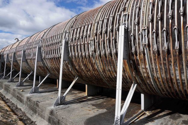
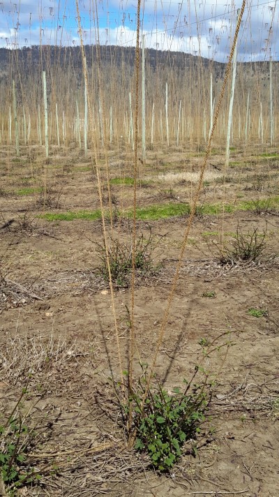
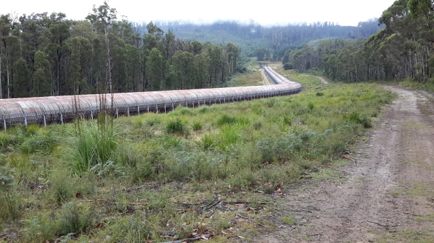
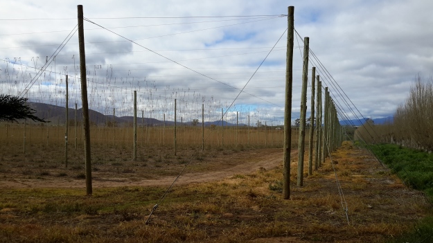
On occasion, where the meaning was clear because I could recognise specific locations, I enjoyed some of the lines. For example, “…rows of hops that string this neck of the river…” referred to the hop vines and their structural strings in the Bushy Park area.  These hop fields obviously made a significant impression on Justy and Margaret because there was a second comment on the same topic; “…the hops in single file march orderly disruption to the valley.”  Then, when they walked around the Wayatinah Power Station, “…the woodstave pipeline is a blistering gland … Draws the corset of her breathing”.  Like Justy and Margaret, I looked in awe at these two locations and their dramatic impact was described during my posts.  To remind you – here are photos of the hop fields and others of the wooden pipeline.   20150918_104145.jpg
20150918_113007.jpg

20170424_114515.jpg

DSC01655e.jpgJusty and Margaret learnt in Cumbria; “On the banks of the River Derwent, that the term ‘black market’ is born. Through the illegal trading of graphite.”  Then they found graphite was part of the geological structure at Wayatinah on Tasmania’s Derwent.  From these findings, grew the idea to play with ‘black’; the book’s cover is black, some copies are cloth bound and impregnated with carbon powder, the Fall of the Derwent and ‘black’ are interconnected within the text, and one section of the book presents a list of locations along Tasmania’s Derwent which include ‘black’ in the name; examples include Black Bob’s Rivulet and Blackmans Bay.

Phillips/Woodward’s book Fall of the Derwent was part of a public artwork presented in association with GASP (Glenorchy Art & Sculpture Park) in 2016. Further information can be accessed here. If you click on ‘Download Hydrographic Score’ you will be able to read the book online.
Piguenit at Lake St Clair

Since my walk from the mouth along the Derwent River culminated at the source, Lake St Clair, writing one of the final blog postings about my favourite Tasmanian artist Piguenit who painted Lake St Clair a number of times, seems appropriate.  Previously in the posting Piguenit- artist extraordinaire in southern Tasmania, I extolled some of his virtues.

The story goes – in one of my former lives, in my arts and museum career, I started in the profession working at the Tasmanian Museum and Art Gallery – in three ways: I gave the occasional public lecture in the art gallery section, I volunteered and worked on the art collection in the bowels of the building, and I was employed as a cleaning and security attendant.  Because of my art knowledge and interest I was usually allocated the large gallery at the top of the building for the security detail, the one with the 19th century paintings and sculptures. In those days there was no cover on the roof windows, no insulation and no heating.  This is late 1970s and I recall being frozen for most of my winter shifts standing there.  But the win for me was that all the TMAG’s big Piguenit paintings were hung at one end of the gallery.  Until then I had never seen his work. I was bowled over by their majesty, their drama and with the artist’s skill.  Most especially, for the first time, I saw an artist painting serious pictures in oil but sometimes only using black and white paint and creating an image with greys (some were slightly yellow greys).  I marvelled at this and have adored his work ever since.  When I come across one of his pictures in any Gallery of Australia I simply stand in reverent silence. His work has that effect on me.

Recently I received a card for a milestone birthday from a couple of stalwart walkingthederwent supporters. The image on the cover was Lake St Clair, the Source of the River Derwent, Tasmania 1887.  Piguenit delighted in this lake and its glorious mountainous surrounds.  The image below, courtesy of Artnet, is very similar to that on my birthday card (regrettably I can find no online reproduction of ‘my’ image).

william-charles-piguenit-lake-st-clair-the-source-of-the-river-derwent-tasmania

The original oil on canvas, shown on my card, was presented to the Tasmanian Government  in 1889 and is now housed in the Tasmanian Museum and Art Gallery. The differences between ‘mine’ and the Artnet versions include the fact that the latter is a smaller canvas and the foreground rocks and sand are shaped and painted differently. My earlier posting has another image of the same location – one which is held in the collection of the Art Gallery of New South Wales.

Clearly the birthday card was sent with my recent walkingthederwent project in mind but without knowing my decades long ‘connection’ with Piguenit’s work. That image of Lake St Clair with Mount Olympus spot-lit is a stunner.  Now I wonder if the impetus for my walk along the Derwent began in that freezing Gallery all those years ago.  How could I have known what my future held and where I would end up?

Recapping the walk along the Derwent River


I lived the walk along the Derwent with a vital obsession but, after so many months intensely engaged on other projects, now some of the details are vague. To re-immerse myself into the experience, I am writing this post.

In addition, I suspect it will be a great help to people who have become followers of my blog during the past 6 months.  Despite my inactivity, it surprises me how many visitors and views the blog gets daily, how many different posts are read, and how many different countries around the world are represented.

In August 2014, from an impulsive unplanned idea, I took a bus to a spot near the mouth of the Derwent River on the eastern shore, walked to the sea then retraced my steps and began the walk towards the source of this great river approximately 214kms inland.  On day trips, and around other life commitments, I walked in stages along the eastern shore until I reached the Bridgewater Bridge which crosses the Derwent approximately 43 kms upstream.

Instead of continuing inland, I crossed the bridge and headed back on the western shore towards the southernmost  mouth of the River.  Most of the walks along the eastern and western shores between the sea and the Bridgewater Bridge were along designated pathways, although some informal track walking, road walking and beach walking was required during my trips.

Then I returned to the Bridgewater Bridge and began the journey inland expecting only to walk on the side of the river that made passage easiest.  I had no intention to walk both sides from this point onwards in anticipation the landscape would be inaccessible for a number of reasons or particularly wild with dense and difficult forests. I walked to New Norfolk on the western/southern side of the Derwent but from then on, I switched from side to side. Using maps I determined where I must take up each new stage of a walk while switching from side to side, so that I could say I had traipsed the entire length of the Derwent River.

The farthest inland stages of my walk are easily defined.  I walked from near the township of Tarraleah besides Canal 1 (along which is transported Derwent River water) above the actual River bed, past Clark Dam, and around majestic Lake King William to the township of Derwent Bridge.  From there I followed the river to its source at St Clair Lagoon dam.  In case some people believe the source of the Derwent is further inland, I walked onwards to the weir where the Derwent Basin empties into the St Clair Lagoon via passing the southern end of Lake St Clair.

Between New Norfolk and the area near  Tarraleah, my walk beside the River was in country near  townships (some of which were located at a great distance from the River) such as Bushy Park, Gretna, Hamilton, Ouse, and Wayatinah.  This necessitated additional travel to or from the highway and roads, on which these towns exist, to reach the river or to return home from a walk along the river.

Inland, the water of the Derwent River is controlled by dams constructed to create hydro-electricity for Tasmania: I walked past them all. From the end of the river closest to the mouth, these are the Meadowbank, Cluny, Repulse, Catagunya, Wayatinah, Clark and St Clair Lagoon dams.  Each of these has a bank of water behind them:  Meadowbank Lake, Cluny Lagoon, Lake Repulse, Lake Catagunya, Wayatinah Lagoon, Lake King William and St Clair Lagoon.  Most of these dams and bodies of water has a power station: Meadowbank Power Station, Cluny Power Station, Repulse Power Station, Catagunya Power Station, Wayatinah Power Station and Butlers Gorge Power Station.  I was privileged to be shown around one of these power stations during one walk.

Water from the Derwent passes through two other power stations:  Nieterana mini hydro and the Liapootah Power Station.  I did not follow the trail of these Derwent River managed flows.  The water from other locations inland passes through the Lake Echo Power station and Tungatinah Power Station then flows into the Derwent after power generation, thereby increasing the volume of water flowing downstream.  I did not walk along these feeder rivers.

The few stages of the walks which have not been recorded in this blog, are in all the zone between Gretna and the area near Tarraleah – a stretch of perhaps  120 km.  I have written up and posted most of the walks in this zone, and now it’s time to add the missing sections.

Andrew Hughes has walked, rafted and canoed the Derwent over the past month

My last post introduced the Expedition Class’s  latest project.  The key man during the journey was Andrew Hughes and now his trek is complete.

The first newspaper coverage of this story was published in The Mercury last May.

The Mercury published another story recently ‘Warm welcome for adventurer Andrew Hughes as he paddles into GASP‘. His journey started north east of Lake St Clair in central Tasmania and now Andrew has crossed an imaginary finish line between the Iron Pot on the eastern side of the Derwent River and Tinderbox on the western side and this conclusion has been covered again in The Mercury.

If you go to the web,  you can read the mini ‘Live Reports’ of the 28 sections of his journey. You can peruse a collection of photos for each section. The information in the reports is limited and no information is offered with the photographs.  Unless you have travelled the  edge of or on the Derwent River, it would be difficult if not impossible to identify locations.

A comparison of some of Andrew’s photos with those I took during my walk from the mouth to the source of the Derwent River, makes for interesting viewing.

Firstly I would like to compare the rush of water over the river rocks between Wayatinah and Butlers Gorge that Andrew saw compared to the low almost absent water level that I experienced on two occasions. Since I completed my walks along the Derwent earlier this year, Tasmania has been inundated with unexpected high levels of rain which have raised the water levels in the dams and the Derwent River.

The photo below was taken by me in October 2015.

20151029_113841.jpg

The next photo was taken by me in January 2016

20160115_130427.jpg

The photo below is by Andrew as shown in his Live Report 18.

1471514898-IMG_3177 from 18 of expedition class live reports.JPG

My photo below shows the water level of the huge 15 kilometre Lake King William was so much lower in October 2015.

20151029_123314.jpg

My photo taken only 2 ½ months later at the beginning of January this year, showed the water level  had dropped dramatically so that the Tasmanian government was considerably worried about our electricity generation options.

20160102_155721.jpg

In Live Report 15 Andrew shows the Lake King William water backed up to Clark Dam at Butlers Gorge. Tasmania is no longer worrying about our water storage facilities and power generation. Again we have enough water to create clean electricity.

1471254936-IMG_3085 from live report 15.JPG

These photos are wonderful reminders of the unpredictability and power of nature.   Andrew’s reports and photos are an excellent example of people getting out into our Tasmanian wilderness and experiencing it’s challenges and wonders.  I hope his trek inspires others not necessarily to cover the same territory, but to find new country to discover and enjoy.  To be refreshed by the purity of the bush.

More adventurous walkers are tackling the Derwent

Last January artist Justy Phillips and writer Margaret Woodward walked along sections of the Derwent finishing at Lake St Clair using the support of friends.  On some days they were accompanied by others.

This week  I discovered that a group of children are currently engaged in a ‘Derwent River catchment school program’. They started their supported walk further inland in the upper catchment areas of the Derwent River, north west of Lake St Clair, and are yet to commence their trek towards the sea. In winter!  What a strange choice of season to walk with inexperienced young bushwalkers in central Tasmania.

You can read more about their walk in the news story 

Details of the program are available on the Expedition Class website.  The site includes ‘Live reports’ which record the extreme weather rather than their progress.  They are yet to walk around Lake St Clair before tackling some of the most challenging sections of the Derwent River.  I wish them all the best.

Since starting my walk from the mouth to the source of the Derwent River late in 2014, I have met people and heard of others who are considering walking the Derwent.  Currently there are no walking paths for most of the 215 kilometres, and the dense almost impenetrable bush along the river edges in the upper reaches, makes this a dangerous activity for inexperienced bush walkers.  Readers of my blog will recall that permission to walk on private land is not always given making some river sections inaccessible – this means that future walkers might not be able to accomplish their goal.  If the numbers of people who seek to walk on private agricultural land increases, then even the most positive and supportive of landowners may decline to allow access to protect their livestock and property.

With the growing interest in undertaking such a journey, the time has come for Tourism Tasmania and the Department of Parks and Wildlife Service to examine the obstacles which need surmounting, to make a walk along the Derwent River possible and safe.

Writing up the ‘gaps’ in my walk along the Derwent River

20160104_090210.jpg

The photo shows water entering the Derwent Basin from Lake St Clair.

Despite my excitement when I reached the source of the Derwent River, I recognised there were some kilometres not yet walked or which had not had their stories told in posts on this blog.  Despite earlier misgivings and qualms about walking some edges of the Derwent River, I renewed my commitment to complete 100% of the length from the mouth to the source, and to create a blog which tells the complete story.  My future posts detail those ‘gap’ walks to the extent that I can, considering the confidentiality requirements of some landowners.

For blog followers who recently linked to my site for the first time, you may not be aware that in the earlier stages of this ‘Walking the Derwent’ project, my walks were sequential.  That is, where I finished a walk I started the next walk. However, once I reached the town of Gretna, from then on as I walked inland, my walks occurred out of sequence depending on the weather, access to the land, and a driver to take me to the start of a walk or collect me from the end of a walk.  I imagine for most of my blog readers it has been difficult in the past months to understand to understand how far away from Hobart or from Lake St Clair each walk has been.  Once I have finished writing all the walk posts, I propose to create one post which describes the River in terms of moving from one end to the other sequentially.  Hopefully this will clear up any confusions or uncertainties.

What if the water leaving St Clair Lagoon Dam was not the source of the Derwent?


Different people hold views about the start and finish of places and the same is true for the Derwent River.  So, just in case, someone should say to me that the River’s source is at the weir where water flows from the Derwent Basin into St Clair Lagoon, or the source is where the water flows from the body of Lake St Clair into the Derwent Basin, I walked to both other locations to be sure I had arrived at ‘the source’.

From St Clair Lagoon Dam I returned to the Pumphouse Point road and continued towards Lake St Clair and the Hotel.  Trees flanked the walk.

20160104_082932.jpg

20160104_082941.jpg

And I passed unwalkable wetlands.

20160104_083218.jpg

Suddenly one corner of spectacular Lake St Clair stretched before me, and I could see the outlier of the Pumphouse Point Hotel sitting crisply on the Lake, roughly marking the entrance of water to the Derwent Basin.

20160104_083442.jpg

20160104_083436.jpg

20160104_083751.jpg

As I walked towards the Point I fell in love with Mount Olympus standing high in all its grandeur. Zeus would be pleased.

20160104_083958.jpg

Gradually I closed in on the Point so that the white box appeared as a building.

20160104_084007.jpg

20160104_084345.jpg

The entrance to the Hotel seemed barred to me.

20160104_084531.jpg

However to the right of the entrance a sign indicated a walking track would take me to the Weir at the southern end of the Derwent Basin.

20160104_084550.jpg

Again, anglers have been remembered.

20160104_084638.jpg

The road to Pumphouse Point

I turned right onto the road to Pumphouse Point rather than continuing on to Cynthia Bay, the main settlement at the southern end of Lake St Clair.

20160104_073545.jpg

The discrete sign to the hotel allowed the environment to dominate.

20160104_073807.jpg

I followed the quiet gravel road northwards.

20160104_073812.jpg

In taking this road it is important to realise you have entered a national park, and that you need to pay for the privilege.

20160104_073859.jpg

20160104_073910.jpg

Before long I passed by a sewage treatment works, although one without a name or identification. A delicate odour gave notice.  I think that now I have walked passed every treatment works on the Derwent River – I am not sure if medals are given out for that sort of achievement.

20160104_074609.jpg

20160104_074727.jpg

Then the bush was my only companion with the Derwent River seemingly running through the trees.

20160104_074731.jpg

Along the route, tracks of various qualities diverged to the River every few metres or so.

20160104_074907

20160104_075212.jpg

20160104_075216


Starting out for the source of the Derwent River

I turned north and walked off the Lyell Highway along the road leading to Lake St Clair and other locations including the source of the Derwent River.  As I walked beside the River, I revelled in the colours of that pure water, and in the mystery of its twists and turns.

20160104_065538

20160104_070604

20160104_070745.jpg

The water clarity was such that I could see the bottom of the River easily.

20160104_070613

I passed an area designed for helicopters to land. There were none waiting, but I heard and saw many flying around every day giving tourists a bird’s eye views of the terrain.

20160104_070849.jpg

I loved the sign alerting drivers to be aware of walkers. The one below amused me because it was placed about 1 or 2 kms from the Lyell Highway and it occurred to me that if walkers were on the road after the sign then they had to be on the road before the sign as well. Like me.

20160104_070921.jpg

Then there was one of my favourite tall-story telling signs.

20160104_071036

This sign suggests our Tasmanian Kangaroos are larger and stronger than a car.  While mainland Australia has some giant sized ‘roos, our Tasmanians grow to a more modest size. However, in any collision, while our kangaroos won’t pick up a car, the power of the contact as they jump into the car’s path can send a car careering off the road perhaps towards a tree, or severely dent it, and personal injuries may result.  That is, both our kangaroos and our wallabies can unexpectedly cause major vehicle accidents.  By the way, our wildlife do not know what we write on signs. When a sign alerts motorists to be aware between dusk and dawn, they may be forgiven if surprised by an animal running or hopping on the road at other times of day.  Motorists must expect a rare occasion when a ‘Jonathan Living Seagull’, a maverick, an animal demonstrating great independence will suddenly appear.

On a more pleasant note and through my walk, the early morning birdsong was a delight. Listen to their crystal clear sounds on this video.

Derwent Bridge

Located 174 kms west of Hobart on the Lyell Highway, the town of Derwent Bridge extends about a kilometre from one end to the other and contains a scattering of private houses and a handful of small businesses. This tiny township takes its name from the bridge in its midst which crosses the Derwent River.  Lake St Clair sits to the north and Lake King William to the south.

I love writing Trip Advisor reviews (as Crocodillus) and after returning to Hobart from Derwent Bridge I wrote four: my accommodation at the Derwent Bridge Cabins, the food experience I enjoyed at Hungry Wombat Café , the Derwent Bridge Hotel, and the Wall in the Wilderness .  A description of these is not particularly relevant to this blog so, if you are interested, I have provided the links to my reviews with a few photographs.  I am happy to answer any email enquiries if you are considering visiting Derwent Bridge.

I stayed in Derwent Bridge for two nights (buses to Hobart do not travel every day) and every chat, communication, look that I experienced with another person was full of positive energy, good will, happiness, and this made the time pass so easily.  It did not matter whether I was connecting with the Cabin owner or her cleaner, the bar and meal staff at the Hotel, the wait staff at the café, or the owner and others at the Wall in the Wilderness, everyone was upbeat and the services the businesses provided were excellent.

In addition, I met many interstate and overseas travellers, almost all of them walkers who had been journeying either on the Overland Track from Cradle Mountain to Lake St Clair, or had been walking some of the day or longer walks in the vicinity of Lake St Clair.  The effect of continuing kind weather on walkers, the fact that their walks had introduced them to environments which they found profoundly beautiful, and their plans for future walks and discoveries were the catalyst for everyone to buzz with vitality. Infectious.

What goes up goes down

In any landscape, every hill has its ups and downs. Having crested the hill separating me away from Lake King William but with the Derwent River on my left as I walked northwards, I was astonished that I could see Lake St Clair.  There, as a bright white beacon on the water surface, was the Pumphouse Point Hotel. You will need to enlarge the photo below to see the tiny white block in upper left centre. To its right a small portion of the Derwent Basin can be seen. The Derwent Basin empties into St Clair Lagoon, and where that Lagoon is dammed, the Derwent River starts its long run to the sea.

20160103_103751.jpg

Of course the source was still a long way away, but I knew seeing this vista meant I was closing in on the point where the Derwent River started.

Then I started downhill on the sharp rocky track.

20160103_103831.jpg

At the halfway down point, I photographed the view both up and down.

20160103_110309.jpg

20160103_110407.jpg

20160103_110401.jpg

Before long I was walking with the River to my left and a dry forest beside me.

20160103_110548.jpg

Yesterday I walked to the source of the Derwent River

Over the past four days I have enjoyed remote, off-the-main-track inland Tasmania from Clark Dam at Butlers Gorge, along the edge of Lake King William to the town ship of Derwent Bridge, and then further north to where the Derwent River commences out of the gates of St Clair Lagoon.  I continued further north also to the Weir which controls water into St Clair Lagoon from the Derwent Basin (which is kept filled with water flowing from Lake St Clair).  Dozens of posts with all the details of the walks, and accompanied by some grand photos, will be forthcoming over the coming days.

This latest walk means I have walked most of the length of the Derwent River from the mouth to the source.  There are only a few gaps to fill if I have the courage (or a moment perhaps of insanity because of the level of difficulty I believe is involved) in the coming weeks.

For the moment, I thought a few photos would be in order to whet your appetite for more.

The photo below shows one aspect of a view across Lake King William in the late afternoon.

20160102_170531.jpg

The photo below looks across Lake King William early in the morning.

20160103_072935.jpg

Sun passing through gum leaves.

20160103_110629.jpg

The Derwent River early morning near Derwent Bridge.

20160104_064805.jpg

The source of the Derwent River – the water as it leaves St Clair Lagoon. I was standing on the dam when I took the second photo, and watching the water run away eventually to pass New Norfolk then Hobart and finally exit into Storm Bay before dispersing into the wide ocean.  The whole experience was quite marvellous.  The river was fresh and alive!  And so was I!

20160104_075644 20160104_081109


Help is on its way

Tasmania is fortunate to have excellent emergency services so that when you need help, ambulances, fire trucks, police, and special emergency services (SES) come to your aid.  Sometimes this involves boats and sometimes this involves helicopters. In a local newspaper article earlier this week, the Westpac Rescue helicopter collected people from five locations. Two of these are connected with the Derwent River.

One person fell down a cliff at Pearsons Point, the location which,in my estimation represents the western mouth of the Derwent.  Long term readers of this blog may recall my photographs from this location – high up and looking out and across to Bruny Island. When I walked there, I remember making the decision not to try and clamber down the cliff.  Reading this news story now makes me glad that I resisted the opportunity to get closer to the water.

The article reported another person was rescued from somewhere near Lake St Clair, and the source of the Derwent River is that Lake.

It does not matter where you are, if you can signal for help (don’t forget your Personal Locator Beacon) then Tasmania’s rescue services will reach you.

Clark Dam

Clark Dam map

Late in October 2015, on the northern side of the Derwent River, I walked at Clark Dam built on Butlers Gorge, and then along a little of Lake King William. We know that in 1835, George Frankland followed the Derwent River in a southwesterly direction from Lake St Clair across huge plains until the gorge country commenced. The Clark Dam has been built at that junction, and over the decades the plains behind have been swamped with what is now known as Lake King William. The location is a place of extreme weather conditions, from blizzardly snows to ferocious and bitterly cold winds and to scorching sunny days, but always stunning.

Clark Dam is a massive piece of engineering in a beautiful but remote area of central Tasmania.

20151029_122628.jpg

20151029_122354.jpg

20151029_122454.jpg

Chantale’s aerial photograph below puts the Dam and Lake King William into context.

IMG_3876Clark Dam

Michelle’s photos below provide similar information.

PA280110Clark Dam.JPGPA280111Clark Dam.JPG

In 1952 a special tribute plaque was installed on the Dam: ‘The Hydro Electric Commission, Clark Dam, A Tribute, To those who conceived this project, who laboured on its construction, who made its accomplishment possible, a united effort to harness the forces of nature for the benefit of mankind.’

20151029_122335.jpg

Another plaque nearby records: ‘The Hydro Electric Commission, Clark Dam, Named in honour of his Excellency, Sir Ernest Clark,  G.C.M.G., K.C.B., C.B.E., Governor of this State, 1933- 1945.’

20151029_122849.jpg

My chauffeur for the day Andrew, remembered years ago he walked across the Dam wall but that is now impossible.

20151029_122312.jpg

20151029_122459.jpg

This means it is impossible to change from one side of the Derwent River to the other at this point.  In the photo below despite the walkway beckoning a walker, it was impassably gated at the other end.

20151029_123303.jpg

The reminder that the Clark Dam is part of an electricity generating project is everywhere.

20151029_122528

Aboriginal Cultural Walks in Tasmania

Tasmania’s Parks and Wildlife Service provides information about an Aboriginal Cultural walk, the Needwonnee Walk, in the very remote southwest of Tasmania.  In addition, information is provided about a cultural walk at Lake St Clair – here. The Tiagarra Walk in Devonport on the north-west coast of Tasmania, is introduced on this website. Last weekend I visited Devonport and went to walk in this Mersey Bluff area before learning that the site was closed.  Alas.

Mersey Bluff Devonport Nov2015.jpg

However, I was born and grew up west of Devonport where I could look out at Bass Strait during those early years of my life.  Standing and listening to Bass Strait with the onshore breeze blowing into my face brought back many memories.  This felt right. This was my place. I knew my place.

Bass Strait Dpt.jpg

Watch this video to hear the sound of the Bass Strait waves lapping the stony shore near Mersey Bluff.

Journalist David Beniuk reported (Sunday Tasmanian 1 November 2015) that a survey of Australian holiday makers found ‘more than a third of domestic tourists would consider an Aboriginal cultural walk on their next trip to Tasmania.’ He went on to say ‘The results have buoyed the proponents of a four-day trek through the traditional homeland of Tasmania’s Aborigines from wukalina (Mt William National Park) to larapuna (Eddystone Point) in the North East.’

The Aboriginal Land Council of Tasmania is seeking funds to build huts based on Aboriginal building practices, and to set up the walk as a commercial operation.  The walk would include traditional stories, bush tucker and premium Tasmanian produce.  I like the concept of a four day walk because it provides sufficient time for walkers to forget their city or other lives and immerse themselves in the sights, smells, sounds and tastes of the land.