
- What is this blog about?
The blog records my walk on the eastern shore of the Derwent River from the mouth on the South Arm peninsula to the source at Lake St Clair in central Tasmania, Australia. In addition, the blog covers my crossing the river at Bridgewater from the eastern side of the river and the walk back to the mouth of the river on the western shore in the Tinderbox area.
The walk is now complete – the story and photographic record in this blog of all the walks is not complete. During 2016, I had a 9 month break in writing up the walk due to other commitments. Now that I have restarted the record, I anticipate that the final blog postings will occur early in March 2017.
- Why did I take this walk?
My aims included:
- to determine whether accessing opportunities to travel on foot to key parts of Tasmania via public transport, is possible.
- to access all starting and finishing points by public transport. In this way, others including tourists can follow in my footsteps for one or all stages without needing a vehicle.
- to see, smell, hear and learn more about the environment close to my home.
- to inspire others to make their own special projects and to get out of their houses and discover the unusual world near where they live and further afield.
- to motivate others to enjoy the pleasures of walking in the great outdoors
- to give myself an achievable but significant personal challenge.
- When was the first walk?
The first walk occurred on 15 August 2014
- How many walks were taken?
Originally I thought of each walk as a stage and completed thirteen sequential one-day stages from the mouth at the eastern shore to the mouth at the western shore of the Derwent River, plus two others: from Granton to New Norfolk and a two day stage from New Norfolk to Gretna. Between Gretna and the source of the Derwent River at St Clair Lagoon/ Derwent Basin. Lake St Clair the distance was covered with nineteen distinct walks. Some walks were undertaken over one day while others took two days. Only four walks were completed over two days.
- What was the general route taken?
On the eastern shore of the Derwent River from the mouth:
- Cape Direction, via South Arm to Opossum Bay (South Arm peninsula) (mouth of river)
- Opossum Bay to Gellibrand Point (South Arm peninsula)
- Trywork Point to the southern part of the suburb of Tranmere
- The southern part of the suburb of Tranmere, via Howrah to Bellerive Bluff
- Rosny Point to Geilston Bay via Montagu, Rose Bay and Lindisfarne
- Geilston Bay to Risdon Cove via Shag Bay, Bedlam Walls, Tommy’s Bight and Risdon
- Risdon Cove via Otago Bay to Jetty of Old Beach
- Jetty at Old Beach to Bridgewater Bridge, across the Bridge and causeway, and some way into Granton South
- York Hotel in Granton South to MONA in Berriedale
- MONA in Berriedale to Hunter St Hobart City
- Hunter St Hobart to Hinsby Beach south of Taroona
- Hinsby Beach to Blackmans Bay Beach
- Blackmans Bay Beach to Pearson’s Point (mouth of river)
- Granton/Bridgewater Bridge to New Norfolk Bridge on the Lyell Highway and side tracks
- New Norfolk to Gretna via Bushy Park
- Between Gretna and Repulse Dam
- Between Repulse Dam and Clark Dam
- Around Lake King William from Clark Dam to Derwent Bridge
- Derwent Bridge to source at St Clair Lagoon Dam
- St Clair Lagoon dam, via Lake St Clair to Derwent Basin Weir
- How long is the Derwent River?
I don’t know the definitive answer to this.
- 249 Kilometres (149 miles) – according to Wikipedia.
- 182 Kilometres (113 miles) – according to Encyclopaedia Britannica
- 187 Kilometres – according to http://www.pleasetakemeto.com/australia/derwent-river/information
- 203 Kilometres – according to http://www.bonzle.com/c/a?a=p&p=209362&cmd=sp
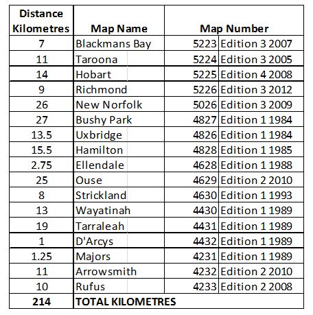
- On 28 August 2015, I used a vintage Curvimeter Opisometer measuring tool to follow the centre of the Derwent River from the mouth to the source on all the latest 1:25,000 maps and measured the length of the Derwent River to be approximately 214 kilometres.
- What was my time frame to walk the length of the Derwent River?
When I started the walk, I allowed 2 years to complete the walk from the mouth to the source at Lake St Clair, plus the section on the western shore from Granton back to the mouth of the river. My intention was always to live life around the occasional walk, not to walk in the cold wet windy and snowy winter months, and to enjoy the entire experience.
- What did I wear on day walks?
- Solid ankle supporting walking boots, with socks
- Long cotton trousers
- T- shirt (either short sleeved or ¾ length sleeve depending on the weather)
- Wind resistant fleece jacket
- What did I wear on longer walks?
- Solid ankle supporting walking boots, with socks
- Long sturdy moisture resistant walking trousers
- Long sleeve nylon polyester shirt with collar
- Thermal top
- Wind and water resistant Gore Tex jacket
- What was in my day-walk backpack?
- Maps, street directory and bus timetables
- Two bottles of water
- Packed lunch
- Note book and pen
- Mobile phone
- Tablet for photographs
- Bandaids/plasters for first aid
- Woollen beanie (in the cooler months)
- Sunhat
- Suncreen
- Umbrella – small foldup
- Plastic bag with a pair of fleece trousers and a thermal top (in the cooler months)
- Small roll of toilet paper
- Plastic bag for my rubbish
- What was in my overnight backpack?
- Maps, street directory and bus timetables
- Tent
- Self-inflating mattress
- Sleeping bag
- Billy
- Spork
- Can of butane gas
- Platform for attachment to gas canister; a mini stove burner
- A windbreak to surround cooking meal (rolled sandwiched cardboard)
- Cigarette lighter
- Two 1 litre bladders of water
- Zip locked bags of dried food meals, rolled oats, nuts and dried fruit – the number of bags depends on how many days of walk is scheduled
- Note book and pen
- Mobile phone
- Tablet for photographs
- Bandaids/plasters, antibacterial cream, stretch bandage for first aid
- Winter beanie
- Sunhat
- Winter gloves
- Gardening gloves for penetrating dense bush
- Suncreen
- Chapstick
- Raincoat
- Plastic bag with a change of clothes to wear at the end of the day once tent is pitched
- Small roll of toilet paper
- Plastic bag for my rubbish
- Knife
- Headlamp
- Pair of thongs for camp
- Novel
- Whistle
- Personal Locator Beacon – SPOT device
- Money and plastic cards
- Plastic tube for siphoning water from creeks/rivers
- Plastic Nalgene bottle to collect water from creeks/rivers to pour into water bladders, and to drink from
- Tent repair material, extra tent stakes
- Billy scourer
- Aquatabs to remove bacteria from collected water
- Glucose tablets for extra energy in an emergency
- Ibroprofen tablets for emergency pain
- Emergency foil blanket
- 2 different coloured Dry Sacks to hold various contents and be easily identifiable when looking into a dark pack
- Microfibre tiny ‘towel’
- Toothpaste and brush
- Device combining USB with voice recorder
- Gaiters
- Reading and sunglasses
- Waterproof pants
- Hygienic handwipes
- Surveyors tape in case I need to mark a route
- Compass
- What else do you want to know?
Please email me on walkingthederwent@gmail.com if you have any questions or you do not want to make a comment online.
If you want to know who I am then go to: https://walkingthederwent.com/about/who-am-i/
If you want to know more about how far was the walk then go to: https://walkingthederwent.com/about/how-far-have-i-walked
If you want to know more about the inspiration for my walk go to:
https://walkingthederwent.com/about/the-inspiration-for-my-walk-along-the-derwent-river
If you want to read tips for bus usage in southern Tasmania go to:
https://walkingthederwent.com/about/buses-in-southern-tasmania-tips-for-their-use

This is great … and love the FAQs! I have had quite a history lesson the the origins of names etc! Happy walking
LikeLiked by 1 person
On the length of the Derwent – perhaps you could make reference to Danielle Wood’s comment about the length of Tasmania’s coastline in her short story ‘None of the Above’ (Deep South, Text Publishing, 2012). ‘Virtually infinite’! It all depends how you measure it.
LikeLike
Thanks for this connection. I suspect the length of the Derwent River not only depends on how you measure it (old school ruler, builder’s tape, triangulated with the planets, or using by some sort of technological device) and where you measure it (every little nook and cranny of a bay or inlet, or straight line down the centre) but also whether you had a good breakfast that morning, if the sun is shining, or whether you choose to take a bird’s eye view (which bird). By the time I reach the source of the Derwent River at Lake St Clair, I will be able to add to the ‘official’ records, a new ‘fictional’ distance based on my experience.
LikeLiked by 1 person
Glad to discover another Taswegian. Quite an undertaking you are completing, I wish you well.
Beautiful photo you have as a header, the light on the rocks is fantastic.
LikeLike
Yes that photo is stunning. I have noted some amazing photos being added onto the Rolex Sydney to Hobart race website. It makes Tasmania look wonderful for all our blog visitors. I hope my blog, yours and others will inspire our overseas readers to consider holidaying in Tasmania.
LikeLiked by 1 person
Thanks for your well wishes in relation to my walking project from the mouth to the source of the Derwent River. Despite feeling overwhelmed before starting some stages, everything has always gone smoothly so far and I have enjoyed every walk. On this basis, despite the difficulties I can foresee in later stages, I can only imagine the entire walk will be trouble free (although challenging in parts). The best thing about my walks is the discoveries I have made in a locale I always thought I knew well or well enough. But now that I am down at the micro level of details that I see on my walks, I am finding our environmental and social landscape is incredibly interesting.
LikeLiked by 1 person
I met this inspirational person at the Bellerive market, I say person as I promised not to reveal the gender or any personal details of the walker involved.
I suggest you have a read of the blog if/when you have time, one day a useful guide book may well result from this personal journey. Win win all round of course, as
from the health and lifestyle perspective, any walking one can fit into one’s life is a bonus for your health.
LikeLike
Thanks for your comment. I am looking forward to writing up my latest walk – today I have walked from Hinsby Beach in Taroona to Blackmans Bay Beach. Marvellous day for walking. I hope others have got out there somehow somewhere today and enjoyed their environment.
LikeLike
Some people who read my blog assume I am a slender lean machine powering along the tracks and trails as I hunt out new ways to get to my destinations. Nothing could be further from the truth. Despite all my walking I am overweight. But I do know my heart is all the better for the exercise. I am not going to be restricted just because I am not a small person. One foot at a time. One foot after another. It all helps my body. It doesn’t matter that readers may not walk as far as I do, but any movement is good for you.
LikeLiked by 1 person
adore Hinsby, it and Little Coningham Bay are fave places for sometime fun.
LikeLike
This is soo great! I was wondering where the “About” page is lol and when I found it, made me surprised and speechless at the same time. You’re really inspiring. Keep it up.
LikeLike
Hi Elliot. Gambling/sports betting has nothing to do with the content of this blog nor any of my others so it would not be a good fit. Sorry. Its a no go. Cheers
LikeLike