What does the Derwent River look like from mouth to source? The following maps (created using the Listmap service) are ordered sequentially from the source to the mouth so you can run your eyes down the images and imagine the Derwent River flowing out to sea. In moving through these maps, you will see how the river changes direction dramatically and therefore you may understand why, from time to time in my blog posts, I could refer to the east or south or north or west of the river.
If you want to dig deeper for further information about the specifics of my walks in the different sections of the River, then please use the Search box on my blog’s Home page (on the right hand edge) and add in a location or idea and up should come all the blog posts about that place or idea.
Re the photo below: I stayed overnight in the township of Derwent Bridge and comfortably strolled (but stepping off the roads to allow speeding cars to pass) to the southern end of St Clair Lagoon, the source of the Derwent River. I continued on to the junction of the Derwent Basin with St Clair Lagoon and I walked to the point where Lake St Clair empties into the Derwent Basin. The River runs beneath the Lyell Highway at the township of Derwent Bridge, then the River flows in a southerly direction into the man-made Lake King William.

Re the photo below: The Derwent River flows south into the very long and large Lake King William. I walked along the eastern shore of the Lake.

Re the photo below: Lake King William swells as it extends southwards before coming to a halt against Clark Dam at Butlers Gorge.

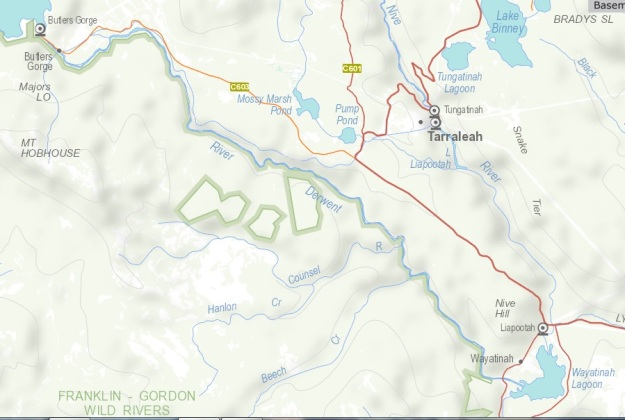
Re the photo below: The thick red line on the right hand edge of the map is a corner of the Lyell Highway. The Butlers Gorge Road starts at that ‘elbow’ and continues to Clark Dam at the southern end of Lake King William. That road is often a considerable distance from the river. Almost parallel to the old Derwent River bed is Tarraleah Canal No 1 which carries the ‘Derwent’ water to Tarraleah’s Power Station.

Re the photo below: This map includes the River from the previous map. In addition it shows the convoluted route that the original derwent River bed follows as it winds to the Wayatinah Lagoon. The best way to walk this is on the river bed (with some occasional forays onto the edges) in the summer –much of the edging bush is fiendishly dense.

Re the photo below: From Wayatinah the old Derwent River bed is comparatively dry until it meets and joins with the Florentine River. Together they flow into Lake Catagunya past the Wayatinah Power Station.

Re the photo below: Lake Catagunya is halted by Lake Catagunya Dam and Power Stations. The flow thereafter fills Lake Repulse to feed the Lake Repulse Power Station. From there the water flows into Cluny Dam, and is processed in the Cluny Power Station.

Re the photo below: The Derwent River emerges from Cluny Lagoon and Dam to run in a generally easterly direction until it flows into Lake Meadowbank. Dawsons Road crosses the Lake in the northern section of this water expanse. This is a superb location for taking photographs.

Re the photo below: Lake Meadowbank is a very long expanse of water and passes many grazing properties. At the northern end the closest town is Ouse. Midway southwards, the closest town is Hamilton although no road access is possible. Eventually it is halted by the Meadowbank Dam and Power Station.

Re the photo below: From Meadowbank Lake the Derwent River flows past many sheep and cattle properties before passing beneath the tiny township of Gretna that is perched on a hill.

Re the photo below: From Gretna, the Derwent River turns and turns and turns again via the hop growing town of Bushy Park and then on past the hamlet of Plenty.

Re the photo below: The Derwent River flows in a south easterly direction to New Norfolk one of the oldest towns in Tasmania.

Re the photo below: From New Norfolk the Derwent River continues until it begins to widen when it approaches The Greater Hobart Area, starting with the suburb of Bridgewater in the Municipality of Brighton.

Re the photo below: The widening Derwent River flows past Bridgewater and suburbs of Gagebrook, Herdsmans Cove, Old Beach, Granton, Austins Ferry, and Claremont.

Re the photo below: From Claremont to Hobart, the Derwent River passes the City of Glenorchy plus its suburbs then the suburbs of the City of Hobart on the western shore, and also the City of Clarence suburbs on the eastern shore.

Re the photo below: On the eastern shore the mouth of the Derwent River is marked, in my opinion, by the tip of Cape Direction and on the western shore the edge of the mouth is Pearsons Point located slightly to the east of Tinderbox. While the South Arm area is located within the City of Clarence, Kingston and Blackmans Bay are located not within the bounds of the City of Hobart rather these suburbs are located in the Kingsborough Municipality.

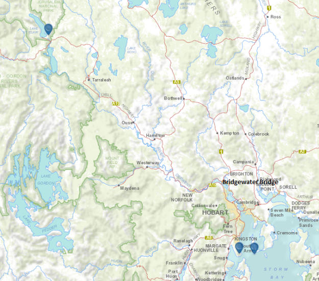
The overview map below pinpoints the source of the Derwent River and pinpoints the two sides of the mouth where the River enters Storm Bay before the sea. Long term blog readers know that I walked from eastern side of the mouth to the western side of the mouth via the Bridgewater Bridge before returning to the bridge and continuing the walk inland.

For newer blog readers who feel like they might follow in my footsteps, please be aware there are no walking tracks between the Bridgewater Bridge and the source of the Derwent River at St Clair Lagoon. I do not recommend others follow me except around The Greater Hobart Area where, for most of the time, formal walking tracks have been built by local government. One of the reasons not to continue past Bridgewater Bridge is that walking on the main roads is extremely hazardous – I cannot recommend it. Also, please note that after New Norfolk few public roads are sufficiently close to the River. In addition and perhaps most importantly, all the country between New Norfolk and the source of the River is owned privately, by corporations or by the Tasmanian government. Determining who the landowners are, researching their contact details, and asking for permission to cross their land is a slow process and not all will grant access.
On this basis, I hope my photographs and stories (more still to be written) will be sufficient for you to enjoy the Derwent between New Norfolk and the source. However, where you can use public roads to access specific points such as St Clair Lagoon, Derwent Bridge, Butlers Gorge and parts of Tarraleah Canal number 1, Wayatinah Power Station, Lake Repulse Power Station, Dawsons Road across Meadowbank Lake, and next to the Bushy Park sports oval, I recommend you make the journey. It will be worthwhile.
