Tag Archives: Fort Direction

The land begins to open, making possible expansive views across the Derwent River.

Every so often, along Tinderbox Road, a cluster of a few properties on 5 acres or so of land each would appear after a kilometre or so of the densely bush environment.

The closer I walked to Pearsons Point the more likely that Tinderbox Road was close to the River or I could see more of the River.  Around 10.20am, while on a long and winding road (on which I considered breaking out into one of the Beatles favourite songs) which undulated so that I was walking uphill then downhill seemingly repeating this process ad nauseum, I was stopped by the beauty of a rose bush in its glorious rose hips stage. I took photographs at that point and in a number of roadside places in the following kilometres.

20150224_101936 20150224_114116

In the distance after climbing one hill, I looked back northwards to Lucas Point behind the steep rock edged bay of ‘Fishermans Haul’ (see photo below).

20150224_103427

In the photo above, the far distant hill on the left is the Alum Cliffs between Taroona and Kingston.  It gives you an idea of the distance covered in these walks.  The other land is on the eastern shore of the Derwent River.

A little further along I was looking down on a disused farmhouse at what I believe was Passage Point.  The photo below shows (green plastic protective shelters around new plants) new trees have been planted in the paddock. I saw such revegetation practices on a number of properties throughout the day.

20150224_103846

Another photo looks across the Derwent River to the southern tip of the South Arm peninsula. The glistening white buildings are those of the Fort Direction defence services complex which I passed through on Stage 1 of my walk along the Derwent River.

 20150224_105611

I am on holiday watching over the Derwent River

Yesterday afternoon I left home, for a week, to live in a unit above Kingston Beach which overlooks the wide expanse of the Derwent  Harbour in Tasmania’s south east.

In future, I will walk along the edge of the Derwent River below as part of my stroll along the Derwent from the eastern shore mouth to the western shore mouth and then from Granton to the source.  Here I am located very close to the mouth on the western shore. I feel tempted to walk the last kilometres this week, and then go back to Berriedale and walk the remaining distance to Kingston. The weather and Christmas commitments will influence the decision.

I am living in a leafy suburb where the rain has pattered through most of the night.  The ground is moist, the air is clean, and the vegetation looks delightfully healthy. This morning, despite slight drizzle, I have taken photos from and around where I am living to give me a sense of place.

20141223_092336 20141223_092147  20141223_092341

The water and the air over the Derwent River are pale and silvery. The sky and water blend softly over disappearing hills so that they all seem to slip from my eyes. Details are scant. Focusing is difficult.  It is not surprising that the photo below shows no water detail.

20141223_092053

Last night in the evening’s continuing light (today is the longest day of the year) I looked across the Derwent River and could identify the land on which I walked in parts of the first three stages of my walk.  The entrance to Ralphs Bay is marked by Trywork Point to the north and Gellibrand Point in the south stands proud at the northern end of the South Arm peninsula. I can see the northern parts of the suburb of Opossum Bay and, further south, the hill above Fort Direction intrudes into the light wispy sky.

Today is the sort of day when ‘you can leave your hat on’ (rain hat that is) and I am enjoying my holiday so much that I have been ‘singing out of key’ around the place … thanks Jo Cocker. Devotees will remember Jo Cocker’s fourth album was titled “I can stand a little rain”.  Bring it on!

Fort Direction memories

My posting about Fort Direction prompted the following response from a friend:

“Well in 1961, and I can’t find any reference to it on Google, the Fort Direction site was lent to the Methodist youth whatever to have an Easter camp and I was there.  I can remember the chapel and the kitchens etc and my friend Sue and I wandered far and wide and kept coming across rolled barbwire fences that kept us in rather than let us out.  We ventured as far as Roaring Beach which impressed me no end.  Christian youth camps in the 50s and early 60s were the hotbed for discussion especially philosophy and I can remember one of the groups that camp, discussing objectivity and subjectivity.  Lots of the brightest students went to these camps.

And this is when I first saw Ralph’s Bay as we travelled at dusk in a bus to South Arm and Fort Direction.  Over the years I thought this image of the tidal flats, so different from my experience on the north west coast of Tasmania, was something in my imagination. So when I had moved to live in Hobart and was exploring to buy a place, imagine my excitement when I found that very image and it was la de dardle!!!!”  (Or, as the map lists it, Lauderdale)

22 Aug 2014 Leaving South Arm and heading home, and final thoughts – Posting 8 of 8

On the return journey towards Hobart, the bus deviated via large mudflats into the town of Cremorne adding 5 minutes to the trip, then it dropped me at a Lauderdale bus stop for transfer to another bus (because the Opossum Bay bus terminates at Lauderdale) approximately 5 minutes later (with his two way communication, the bus driver alerted the other driver there was a transferring passenger to be collected). Once on the Lauderdale bus, the trip towards Hobart deviated through the suburb of Oakdowns and so a further 5 minutes was added to the journey. After the bussing and the walking I was home in Bellerive at 3.20pm.

In this series of blogs for the first walk stage, I have provided approximate times for various sections of my walk as an indication only. I am short legged and plod slowly (and towards the end I felt I was shuffling like an old man). If you are tall and can happily stride long steps faster, then my walk will not be sufficient to fill the time between buses.  In fact some speedy walkers may be able to continue through the Opossum Bay community and walk to the end of Gellibrand Point, the most western tip of this piece of land before Ralph’s Bay makes its inlet.  My next walk will be designed to complete that section, and then I should be able to advise as to whether fitting it all into 5 hours is possible for the able.

Since it is unlikely anyone else will have my success if they turn up at the gate of Fort Direction and get driven through the site, the only general public approach is to walk along Fort Beach having walked most of Blessington Road.  Based on the information I recorded, I suggest one way on this route from the set down bus stop to the Lone Pine Memorial will take an hour if you take time to enjoy the views and click photographs. Add the half hour return walk between Cape Deliverance and Cape Direction with its gun placement bunker and the whole excursion takes approximately 2 ½ hours.  As an alternative, you could spice it up by jumping the shore rocks like a goat, from South Arm to Fort Beach. I would guess another hour could be added to the duration of the walk.

I noted that the tide was going out while I walked, and that the high tide merged with the dune verges in places on Fort Beach. It made me think that on a high tide, this route might be impassable. In such a circumstance and if you had made the special trip and your heart was set on a beach walk, the expanses of the South Arm beach with their outstanding views, old pines shadowing parts of the dunes, and soft roaring Casuarina trees, would make a very attractive substitute.  You might be lucky, as I was, to see a giant fresh squid washed onto the beach being enjoyed by immature grey feathered winged large Gulls.

Many of our native birds are various shades of black and brown but we also have an array of colourful specimens. During my walk, the sun brought out not only the musical black and white Magpies, the hard cawing jet black Crows, but also plump pink and grey Galahs feasting on the ground, Mr Blue Wren flitting in and out of the shadows, a glorious Mr Robin with his red breast, and a flock of multi-coloured Rosella parrots.

My guess is that I walked around 10-12 kms including getting to the start and then continuing on.  But how much of the 249km length of the Derwent River have I covered? About 7kms. A great start! A memorable day. A very positive experience.

22 Aug 2014 Via Fort Beach returning to South Arm road – Posting 6 of 8

I retraced my steps from Cape Direction and Pot Bay to the Lone Pine Memorial.

On the Pot Bay beach I passed an amazing driftwood ‘shack’ on the beach, as shown in the photo below. Are those underpants swinging from on high?

20140822_101716

After a refreshed look at the Lone Pine Memorial, at 10.25 am (only 1 hour 20 mins since I had left the bus – yet, because I had seen and thought about so many things, the time felt much longer), I turned towards the point of Cape Deliverance. Before doing so, I clicked the photo below which scans Fort Beach towards Johns Point.

20140822_094334

The vehicle track, which wound down the hill towards the Derwent then switched back in the direction of Fort Direction seemed the perfect way to get myself down onto the sandy Fort Beach. Twenty or so minutes later I reached the western end of the beach and easily walked up onto Blessington Road.   The alternative would have been to round John’s Point and continue along to South Arm almost entirely by clambering over a rocky shore.  Of course this was possible however, I reasoned that it would take a lot longer to reach my destination. While walking on the very long Blessington Road, I noticed a couple of public walkways down to the shore, so that if a walker started at the river level they could come up to the road at a later time. A couple of empty house blocks with a water frontage made me consider whether these might provide a way to move from the shore to the road – but they are privately owned so careful thought would be needed before deciding to walk across these.

Half an hour later I reached the cross street Rosemount Lane, a short street which took me down to the South Arm Road.  I continued west towards the South Arm beach, passing by the prominent Cenotaph that remembered many wars including the more recent Iraqi war.

20140822_112246

22 Aug 2014 Arrival at Fort Direction – Posting 4 of 8

After 20 minutes walking from the bus, I stood at a high mesh perimeter fence with a large open gate and massive signs telling me that the land beyond was the property of the Defence Services and ‘Trespassers will be prosecuted’. Cape Direction was so close, and now my access even to the beach from this location was thwarted. Using a number on one of the signs, I phoned the caretaker of Fort Direction (the cluster of buildings between me and Cape Deliverance and Cape Direction) and asked if the signs really meant what they said.  Yes they did.  This is a serious defence location and casual visitors are not permitted. When the caretaker informed me I could take my car and access the beach from Blessington Road, I let him know I was a walker.  He was surprised. So many people don’t walk these days and are surprised when they come across someone who does.  Not missing a beat, he offered to drive to the gate, collect and take me through (the militarised zone – my expression) and drop me at the Lone Pine Memorial on Cape Deliverance. From there I could walk in select places and then return to South Arm via the beach.

I do love the world. Something so good always comes out of something so problematic (and if this isn’t always true, I choose to forget any exceptions). The caretaker was friendly, amiable and chatted generously. I am so grateful for his help.

 Apparently while the wooden buildings of Fort Direction don’t get a great deal of use except by cadets, they have historic value and have been maintained as the result of very strong local community advocacy. But close by, under lock and key are stores of live ammunition.  I wouldn’t have been interested in any, but I guess others might if casual wandering around had been permitted.  Originally the ammunition was stored in the nearby tunnels beneath the old gun placements on Fort Hill (which was out of bounds) – a very secure place and if an explosion had occurred any damage would have been localised.

Yesterday, I trawled the internet to try and understand what Fort Direction was all about. If you are interested a simple google will bring up a great deal of information and photographs.

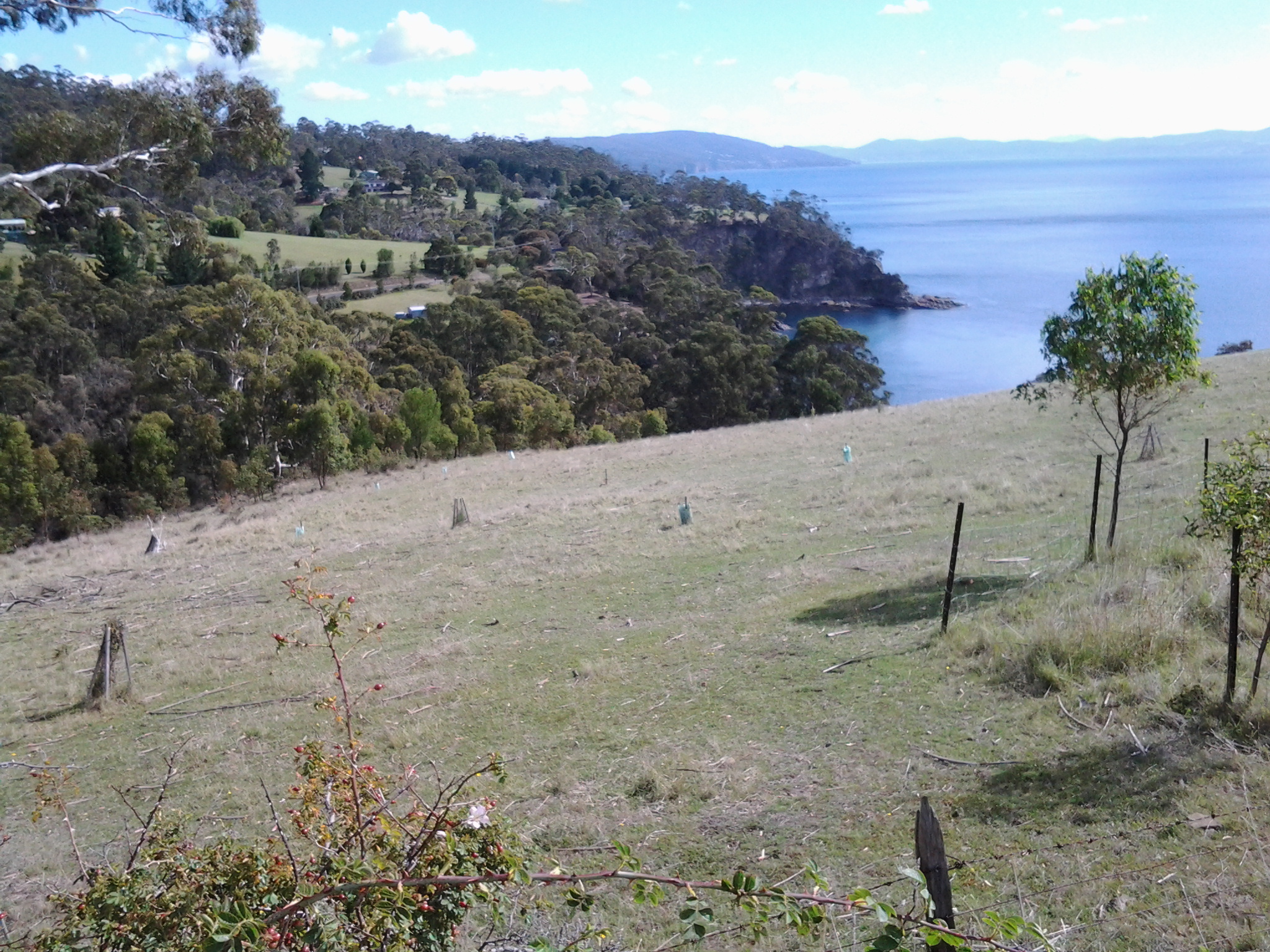
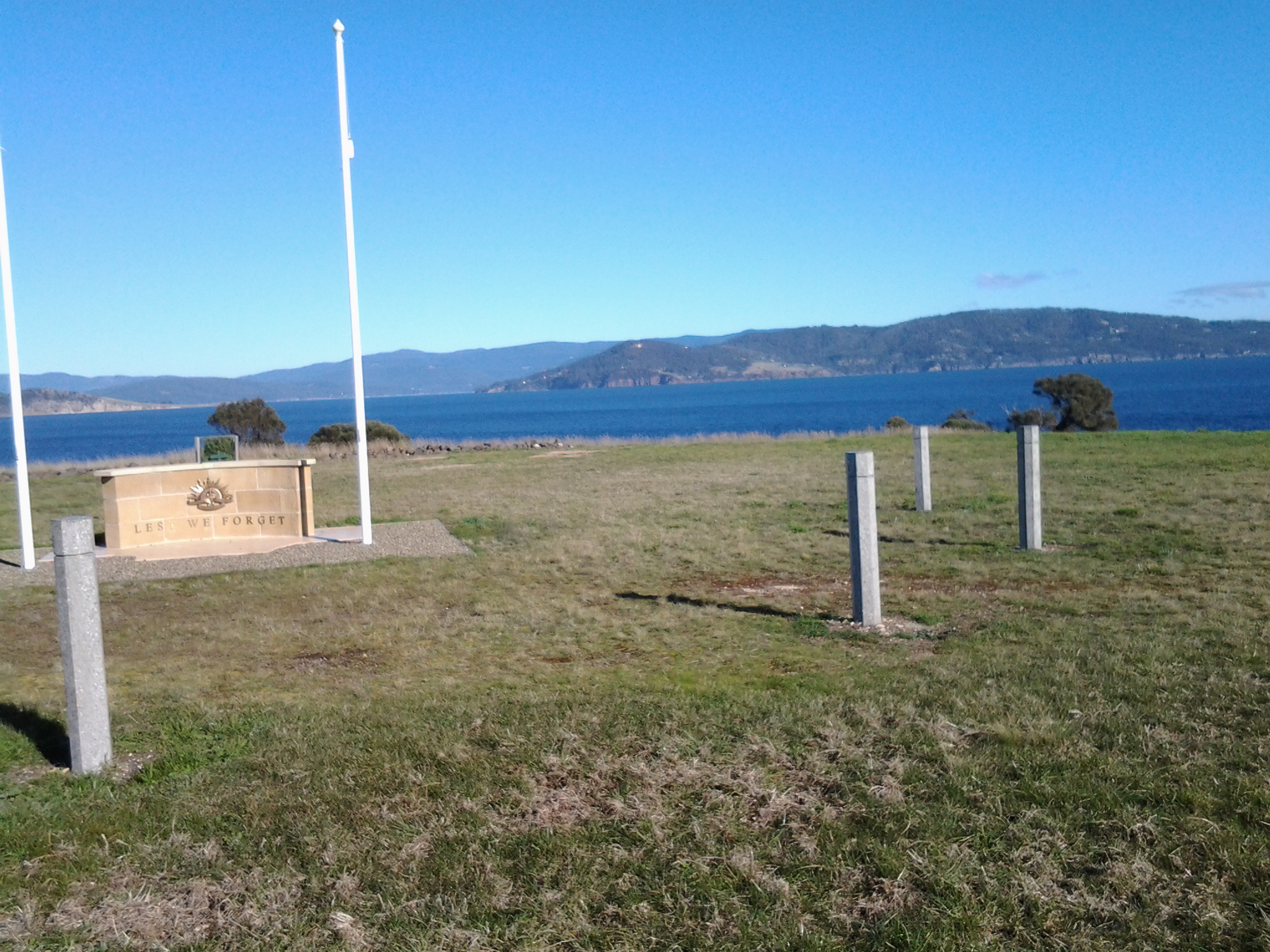
The caretaker drove me out onto the flat exposed and open expanse that is modern day Cape Deliverance. It is above sea level but is not high enough to have the handsome cliffs that I could see across the Derwent when looking at the near Pierson’s Point and surrounds in the Tinderbox area. The first thing I noticed were two tall white flag poles, without flags, standing at the end of a large area. A part of me considered that if two more poles were added, a game of one ended AFL footy could be played here. The ground was extensive and very flat. 

The poles framed a remembrance structure with the words Lest We Forget. In an arc at some distance were seven pillars. On each was the name of the seven Australian servicemen who were awarded the Victoria Cross as a result of their actions at the Battle of Lone Pine near Gallipoli. This was the significant battle fought between Australian and Ottoman Empire  forces during the First World War between 6 and 10 August 1915.  I asked my driver how this memorial came to be here considering none of the 7 were Tasmanian, or ever visited Tasmania, leave alone were locals. The question surprised him, and left him worried. Not only did he not have an answer, I sensed he wondered whether the decision to install this memorial in an isolated place without direct connection to the people of South Arm, was appropriate. 

He left me at the Lone Pine Memorial and I tried to see it clearly with the wind lancing my face.  A melancholy spot. But strikingly beautiful. The caretaker had told me that the physical nature of the location and its views had something in common with the Dardenelles, and that most RSL guys thought it was particularly appropriate site for the memorial.  Anzac Day brings 700 plus people to this windswept site for the dawn service. I can appreciate how the landscape would make the ceremony quite powerful.

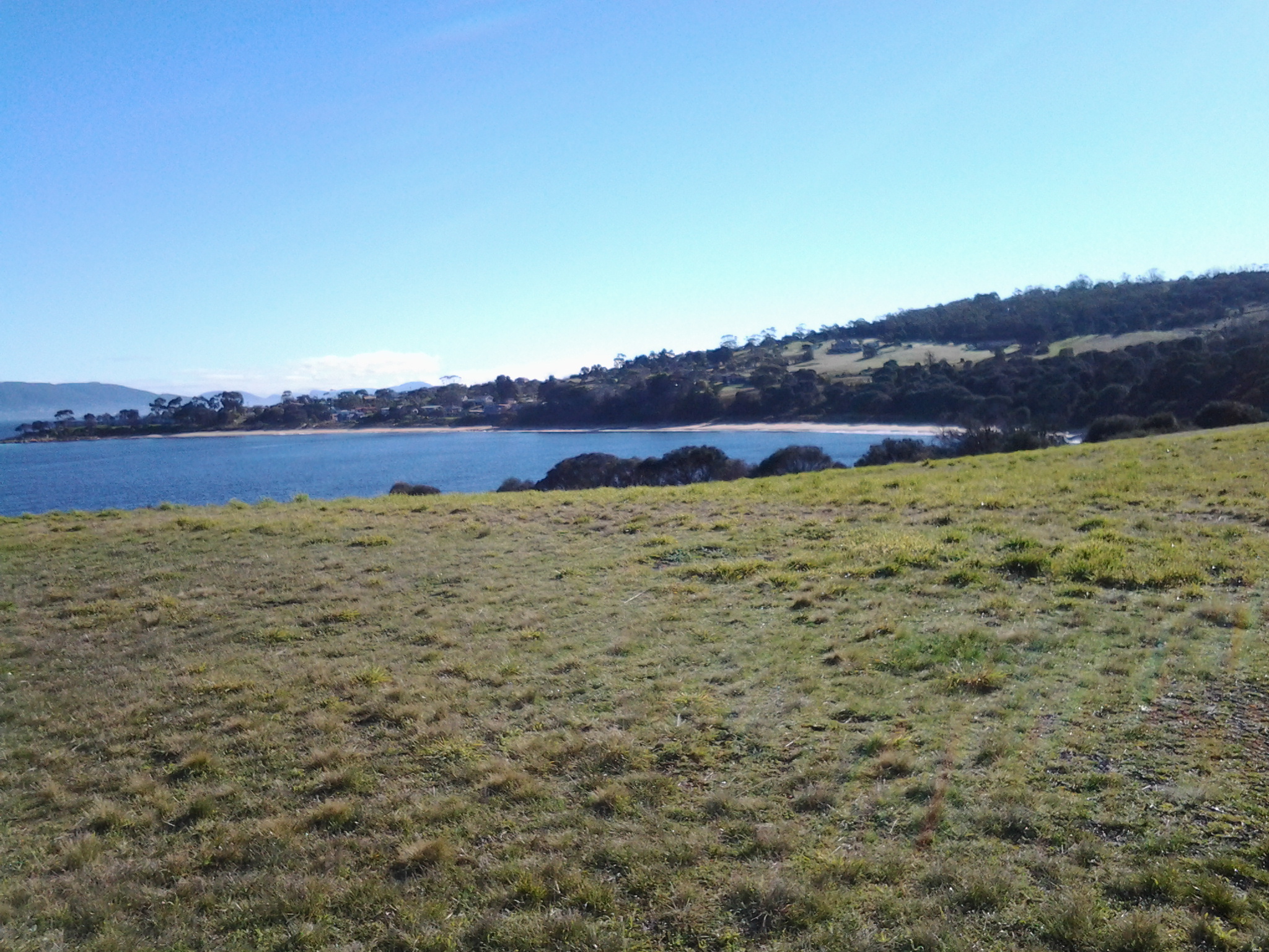
The photo below looks seaward from the Lone Pine Memorial on Cape Deliverance towards the Iron Pot lighthouse.

 20140822_094232

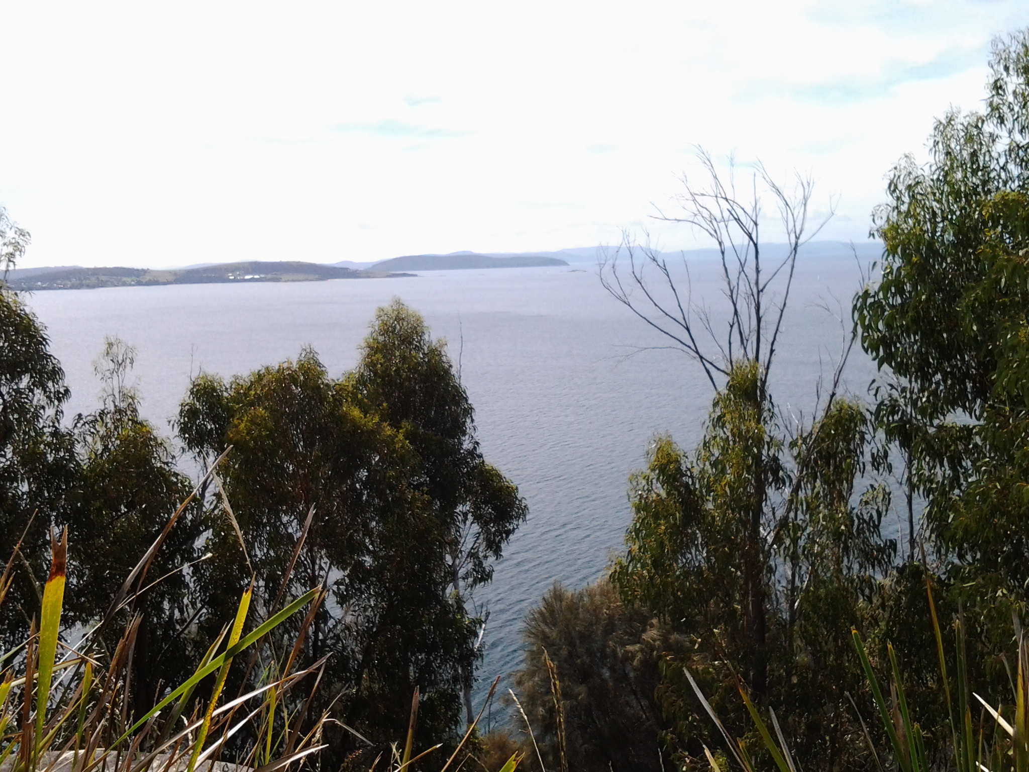
The photo below looks across from the Lone Pine Memorial on Cape Deliverance towards Piersons Point and the Tinderbox area – the starting point for the Derwent River on the western shore.

 20140822_094317

The photo below shows the single pine planted as part of the Lone Pine Memorial. In a cage.

20140822_102521

Planning the first walk

Thanks to Je I was reminded that the grid on a map represents a distance and so, before I started fancifully imagining huge distances could be covered in a single leap, I have slowed down and thought through what is possible. And also what is desirable considering public transport times.

I have made the decision to start on my side of the river, the eastern shore of the Derwent. While stages along the river might be taken in any order, making a start on this epic journey at a key point seemed like the proper thing to do. I will start at the mouth of the river.  I am sure my decision as to where the mouth of the Derwent river starts will be controversial. But this is my walk. My Derwent River walk. Having consulted the maps, I can start where I think it is appropriate.

Previously I have remarked that all walks must be able to connect with public bus services – I don’t own a car, and I realise other future walkers of the Derwent might want to travel without worrying about car ferrying to get them to start and finish points. I accept the bus timetables may limit my possibilities and that I may need to walk additional kilometres simply to reach starting points, or after a finishing point along the Derwent. However, I know I will see and experience additional wonders that someone travelling in a car might miss.

Tomorrow morning the 8.09 Opossum Bay Metro bus from the Eastlands bus stop will convey me to South Arm where I plan to follow the Fort Direction road and continue on to Cape Direction.The Cape will be the starting point of my walk along the eastern side of the Derwent River. Tomorrow’s walk is a study in getting a feel for the time it takes to cover territory in a plodding easy way. It will also give me an indication of the reliability of the State Government maps. I expect to cover about 6-7 kilometres including historical sites, but only a portion of that will be along the Derwent.  This area is serviced by an infrequent bus run and I am aware that I need to be back at a bus stop for the next bus departing Opossum Bay at 2.02 pm.

Today is bright and sunny with that gorgeous cloud free Spring look. I am sorry that I hadn’t planned to start walking today. But my excitement is now building for the start of this epic adventure tomorrow!