Tag Archives: Iron Pot lighthouse

Iron Pot Lighthouse

My wonderful walk from the mouth to the source of the Derwent River seems long past, however from time to time a blog reader refers me to new information.  Thanks Mary for these leads. If you read here and here you will learn more about the history of the Iron Pot Lighthouse.

People who have read my earlier posts will know that I judged the tip of land opposite the Iron Pot to be the ‘mouth’ of the river on the northern/eastern side. I had to walk there from South Arm before my walk along the length of the river from the mouth could start. Here is one of the photos I took of the Iron Pot that day.

20140822_100305.jpg

The Iron Pot enters into the consciousness of many at this time of year.  On Boxing Day the annual Sydney to Hobart international yacht race will get underway.  After the yachts reach Tasmania and have sailed down the east coast, eventually they turn north west into Storm Bay. Not long after, the race organisers will be reporting yachts are in the vicinity of the Iron Pot. I expect the maxi yachts could start rounding the Iron Pot this Friday if they get a dream run.

If you would like to see this rocky outcrop up close without walking, take a Pennicott boat tour from Hobart (https://www.ironpotcruises.com.au/)


22 Aug 2014 Heading for the start of the first walk at Cape Direction – Posting 5 of 8

The photo below shows Cape Direction. To the left of the headland trees is a concrete bunker.

20140822_095939

Heading toward Cape Direction, I walked along a vehicular track eastwards and down onto the firm sand of the beach at Pot Bay.  Large Gulls either Pacific or Dominican patrolled the beach, letting a mix of Pied Oystercatcher and Sooty Oystercatcher birds have a run around.  The protruding flat sandstone rocks on the beach featured empty oyster shells.

 20140822_095103

20140822_095416

 At the end of the beach I clambered up the rocky earthy banks amidst a rich layer of fleshy vegetation that looked good enough to eat. I knew that the pigface plant with bright pink flowers open to the sun was edible, but what about the rest.

The photo below shows a swathe of blooming pig face on the Pot Bay side of Cape Direction.

20140822_095628 

What did the original aboriginal people eat? I would be very interested to learn whether some of the other plants could be used as food.

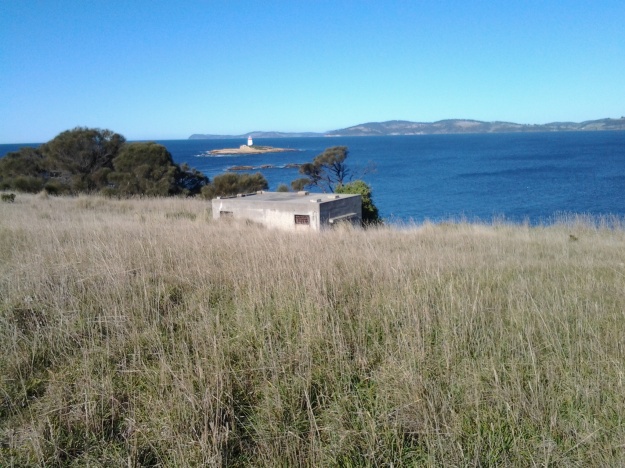
I had been warned that most of the old gun placements on Fort Hill were out of bounds, and again a high mesh perimeter fence made that clear.  But I was able to wander towards the one remaining structure outside this fence – one without tunnels. I waded on through high grass and onto another vehicle track that lead uphill to the remains of a massive concrete gun placement structure.

The photo below shows the concrete structure. The Iron Pot lighthouse can be seen in the distance.

20140822_100305

As I wandered inside the structure, it made no sense to me, and with no information to hand I was left puzzling as to why it was surrounded on all sides by rock and earth so the soldiers would not have been able to see an enemy coming towards the Derwent leave alone fire on such a ship.  Perhaps I am the first non-defence services visitor (can that really be true?) and everyone else who has visited perfectly understands how the building was used. 

From this structure it was a short distance east to open and exposed Cape Direction – the starting point for my walk along the Derwent.  Opposite, almost linked to the mainland at low tide by a series of rocky reefs, was the Iron Pot in all its glory.

The photo below shows Mount Wellington above Hobart, past Cape Deliverance and taken from Cape Direction.

 Towards Cape Deliverance and Mt Wellington

22 Aug 2014 Arrival at Fort Direction – Posting 4 of 8

After 20 minutes walking from the bus, I stood at a high mesh perimeter fence with a large open gate and massive signs telling me that the land beyond was the property of the Defence Services and ‘Trespassers will be prosecuted’. Cape Direction was so close, and now my access even to the beach from this location was thwarted. Using a number on one of the signs, I phoned the caretaker of Fort Direction (the cluster of buildings between me and Cape Deliverance and Cape Direction) and asked if the signs really meant what they said.  Yes they did.  This is a serious defence location and casual visitors are not permitted. When the caretaker informed me I could take my car and access the beach from Blessington Road, I let him know I was a walker.  He was surprised. So many people don’t walk these days and are surprised when they come across someone who does.  Not missing a beat, he offered to drive to the gate, collect and take me through (the militarised zone – my expression) and drop me at the Lone Pine Memorial on Cape Deliverance. From there I could walk in select places and then return to South Arm via the beach.

I do love the world. Something so good always comes out of something so problematic (and if this isn’t always true, I choose to forget any exceptions). The caretaker was friendly, amiable and chatted generously. I am so grateful for his help.

 Apparently while the wooden buildings of Fort Direction don’t get a great deal of use except by cadets, they have historic value and have been maintained as the result of very strong local community advocacy. But close by, under lock and key are stores of live ammunition.  I wouldn’t have been interested in any, but I guess others might if casual wandering around had been permitted.  Originally the ammunition was stored in the nearby tunnels beneath the old gun placements on Fort Hill (which was out of bounds) – a very secure place and if an explosion had occurred any damage would have been localised.

Yesterday, I trawled the internet to try and understand what Fort Direction was all about. If you are interested a simple google will bring up a great deal of information and photographs.

The caretaker drove me out onto the flat exposed and open expanse that is modern day Cape Deliverance. It is above sea level but is not high enough to have the handsome cliffs that I could see across the Derwent when looking at the near Pierson’s Point and surrounds in the Tinderbox area. The first thing I noticed were two tall white flag poles, without flags, standing at the end of a large area. A part of me considered that if two more poles were added, a game of one ended AFL footy could be played here. The ground was extensive and very flat. 

The poles framed a remembrance structure with the words Lest We Forget. In an arc at some distance were seven pillars. On each was the name of the seven Australian servicemen who were awarded the Victoria Cross as a result of their actions at the Battle of Lone Pine near Gallipoli. This was the significant battle fought between Australian and Ottoman Empire  forces during the First World War between 6 and 10 August 1915.  I asked my driver how this memorial came to be here considering none of the 7 were Tasmanian, or ever visited Tasmania, leave alone were locals. The question surprised him, and left him worried. Not only did he not have an answer, I sensed he wondered whether the decision to install this memorial in an isolated place without direct connection to the people of South Arm, was appropriate. 

He left me at the Lone Pine Memorial and I tried to see it clearly with the wind lancing my face.  A melancholy spot. But strikingly beautiful. The caretaker had told me that the physical nature of the location and its views had something in common with the Dardenelles, and that most RSL guys thought it was particularly appropriate site for the memorial.  Anzac Day brings 700 plus people to this windswept site for the dawn service. I can appreciate how the landscape would make the ceremony quite powerful.

The photo below looks seaward from the Lone Pine Memorial on Cape Deliverance towards the Iron Pot lighthouse.

 20140822_094232

The photo below looks across from the Lone Pine Memorial on Cape Deliverance towards Piersons Point and the Tinderbox area – the starting point for the Derwent River on the western shore.

 20140822_094317

The photo below shows the single pine planted as part of the Lone Pine Memorial. In a cage.

20140822_102521

22 Aug 2014 Arriving in South Arm and starting the walk – Posting 3 of 8

At 8.50am the bus was darting past the Clifton Beach turn off and then, after speeding across the low lying road of the isthmus, a little after 9am I was stepping off the bus opposite the South Arm shop. For anyone following in my footsteps, if you need a public toilet, there is one near the beach and the South Arm Shop can point you towards it.

The photo below shows the South Arm Shop, a multipurpose village convenience store.

20140822_112154

As I stepped off the bus, a wonderful wedge of water beckoned me. This was the Derwent River showing itself down the end of a track to the beach. That track started from a roadway that passed by the Cenotaph where the road made a 90 degree angle bend to head onwards to Opossum Bay, all a short way down from the bus stop. But instead of walking towards the river, I turned back along the main road to find my starting street.

My main task was to reach the starting point of the walk along the Derwent, and then to walk as far along the river’s edge as my feet would carry me before the return bus arrived. From maps it was clear I could walk along the Fort Direction Road to the starting point at Cape Direction and then I could return via the coast for a change of scenery. Fort Direction Road was a few metres away from the bus stop.  As I walked up the road (which wasn’t level and wasn’t going downhill) the expression that this was ‘a decent short pull’ came to mind. I seem to remember Nan used the word ‘pull’ when talking about getting a team of bullocks up a short steep hill. Thankfully the pull only lasted about 5 minutes before I was able to follow a gentle upward incline in a more relaxed fashion.

Coming over the rise of one hill, I was surprised to see the crisp white lighthouse with its sharp red painted top on the Iron Pot, not far over the water from the flat top of Cape Deliverance. With the fresh smogless air, the outlines were smart and the tiny rocky islet seemed so close to the mainland.  I was thrilled to see it.  For years I have heard how the Sydney to Hobart Yachts ‘round’ the Iron Pot to enter the Derwent River every December. Now I can visualise this happening. What a sight it must be if the yachts are bulging with colourful spinnakers. Perhaps visiting the area between Cape Direction and Cape Deliverance for such a spectacle should be added to my ‘to do’ list.

My research unearthed interesting tidbits about the Iron Pot. The http://www.abc.net.au/local/stories/2008/11/03/2408589.htm tells that “From 1832 until the early 1880s the lighthouse was the main feature of the site, warning ships of the treacherous waters through which they were navigating. Then, in 1884, it was decided to build a home next to the lighthouse for its keeper James Parkinson and his ever growing family. The home was built only 20 feet above sea level and made the most of a minimal amount of land. One of the greatest challenges for the residents came in 1895 when 90 feet waves battered the coastline. “Waves were breaking over the top of the lighthouse. The people that were in the house moved into the lighthouse for safety. The storm left kelp hanging in the iron railings on top of the lighthouse. Stories also claim the Parkinson home was found to have substantially shifted on its foundations following the extreme conditions.” The site http://www.seasidelights.com.au/au/tas/ironpot.asp?fState=TAS gives some dramatic stormy photos.

The photo below was taken from Fort Direction Road. The flat headland is Cape Deliverance. The white Iron Pot lighthouse shows near the horizon over the slope of Fort Hill.

20140822_092426

The photo below shows a piece of Cape Deliverance on the left and a piece of the Tinderbox area on the right. In between the two prominences, flows the Derwent River.

20140822_092437