Tag Archives: Hobart

The Derwent River in 1958

Recently a friend sent me a link to an extraordinary 9 minute film that was made in 1958. The film is based around New Norfolk, a town located approximately 35 kms west of Hobart. The Derwent River bends around the edges of the rural town that is now built up on both sides of the river.

Enjoy watching the film ‘Valley of the Derwent’, produced by the Tasmanian government, here. Please bear with the excruciating sound of the music so you can listen to the 1950s style narration. The images start at Granton about 18 kilometres west of Hobart. The voice-over explains the original virgin bush ‘had never known the axe or the plough’ indicating a firm belief in the 1950s that taming the wilderness (a euphemism for ‘removing the bush’) was what humans should do. Regrettably there are still too many people (including governments) who feel similarly in 2020.

Early on you see the black swans on the river. David Walsh owner of MONA has just released a diary entry where he refers to the black swan as the unknown unknowns. Makes for interesting reading – here.

I was fascinated that a composer William Wallace, according to the film,  wrote the opera “The Spirit of the Valley” while he stayed at the historic Bush Inn in New Norfolk. It led me on a merry chase through archives and online resources. However recent academic research indicates this is a myth generated over the years, and that even the writing of one song for an opera while he visited New Norfolk is unlikely.

For long term blog followers, the filmed section on the oast houses may bring back to memory my fascination with those at Bushy Park when I ‘discovered’ the texts on the buildings as I walked west from New Norfolk. Refer here.

It made me think how many years have passed and what a world of difference there is since the film was made. For example, I was six years old when the film was produced yet I noted the clothes being worn have the familiar shapes of those of my life through the 1960s.

‘But it’s the river that captivates the eye, twisting and turning along the valley’, so says the narrator. I would say this was true for the entire 213 or so kilometres of the length of the Derwent River.


Hobart and the Derwent River from above

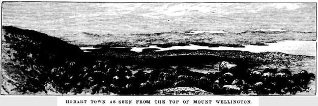
Recently, as I delved into the National Library of Australia’s online digitalised newspapers for family research purposes, I stumbled across the following image.

The newspaper was the now defunct The Australasian Sketcher with Pen and Pencil produced in Melbourne Victoria between 1873 and 1889.  The image below was published in the Saturday issue of 17 April 1875.

Taken from the vantage point of Mount Wellington we are looking down onto the dots of a growing Hobart city, across the Derwent River to the eastern shore which is as yet unsettled in any dense sort of way.  As usual, the River is the star!

River Derwent from top of Mt W17041875.JPG

Fossil Cove posting 4 of 4

I relaxed with the sounds of the wash of the water onto the shore.

20160331_113205

20160331_113312.jpg

20160331_113314.jpg

20160331_113300.jpg

20160331_113317.jpg

After one last look around this deserted Cove and across the glorious Derwent Harbour, I turned toward the path and walked back uphill. Slowly.  Very slowly.  I swear the incline on that hill had steepened. I found each blade of grass and each leaf on the path infinitely interesting and worthy of stopping for closer inspection. Often.

For blog readers who live in Hobart, give yourself a treat, take a picnic with you and enjoy a visit to this wonderful Cove.

‘What’s in a name? A fair bit , actually’ says Rex Gardner

On page 14 of The Mercury newspaper on 5th February Rex Gardner asked ‘What’s in a name?  A fair bit , actually’ about a part of my favourite Tasmanian river.

He talked about the area near the Hobart docks and further out into the harbour and remarked that it ‘really doesn’t have a proper name’.

Rex commented: ‘We call it the River Derwent, or Derwent River. But that name aptly describes the Derwent around New Norfolk, and upriver from there, because a river is a naturally flowing fresh watercourse, flowing towards the sea.  Heading downstream towards Bridgewater, the Derwent becomes an estuary, defined as brackish water fed by streams and rivers, and flowing to the sea.’

When Rex added ‘What flows through the city of Hobart is not a river’, I gasped.  Over time, my blog has addressed the challenges of defining where the Derwent River starts and stops.

To help you to visualise the location, below is an excerpt from Google maps.

Harbour.JPG

Rex Gardner explained, ‘It could be loosely called an estuary, and more properly a harbour, which is a body of water surrounded by land.  The Derwent is 1.4km wide at the Tasman Bridge. From the Hobart docks to Howrah Point is 6km.  From Sandy Bay to Tranmere is 5km.  The Mississippi and the Amazon rivers don’t boast distances like that, except at their mouths or when they flow through lakes.’  Finally he remarked: ‘You have to wonder how the Derwent has suffered the indignity of being called a river for so long.  Just like Mount Wellington got a name change, so too should our Hobart Harbour.’  An alternative fact: our mountain has two official names – Mount Wellington and Kunanyi.

Rex Gardner’s approach adds a new dilemma. To understand some of the legal issues associated with defining a ‘river’ read here, here and here.

The Derwent Estuary Program describes the section of the Derwent between the Iron Pot (at the inner edge of Storm Bay near the eastern shore river mouth) and New Norfolk as the Derwent Estuary rather than the Derwent River and explains it is “a unique environment; a partially enclosed body of water where tidal seawater and fresh river water mix”.

What constitutes our Derwent River – where does it start and stop?  What is the location of its mouth? I have become so used to thinking of the Derwent River starting in the Lake St Clair area and ending around the Iron Pot that these ideas have shaken me up; they are making me question my position.  Does it matter to you? I wonder what others think.

Walking on an industrial site – posting 4 of 5

During the planning phase for this walk on Nyrstar property,  I anticipated that after passing the wetlands treatment area my walk would be finished because, from then on, site buildings and operations sit next to most of the shore. I imagined access to these areas would be impossible for a visitor.

Three times a week, on average, large ships berth nearby ready to load up with the processed Zinc. However it was my lucky day and the wharf was clear.  My host volunteered to take me further if I wished.  Yes please.  It seems that at every turn, on my walk from the mouth to the source of the Derwent River, people have helped and ways have been found to give me access to more of the River than I ever thought possible.  I am so immensely grateful.

Back on a main road we headed towards the wharf, all the while with the river glistening in the strong sunlight and with the shadow of the East Risdon State Reserve ever apparent on the eastern shore.

20170227_105352.jpg

20170227_105726.jpg

20170227_110156.jpg

20170227_105527.jpg

20170227_105542.jpgAs we headed west towards the wharf area, Mount Direction on the eastern shore loomed large.

20170227_110153.jpg

Before reaching the wharf, we passed a repetitive pattern – one which has nothing to do with the Derwent but which attracted my attention.  Bags. Large bags. Heavy bags. Very well organised. Very tidy.

20170227_110506.jpg

20170227_110509.jpg

Nyrstar is an operation which works hard to recycle by-products of the zinc smelting process and to minimise wastage. In association with other Nyrstar operations elsewhere in Australia, the Hobart site uses these bags in the ongoing process. I was impressed with the commitment of this company to repair the degradation of the environment which occurred in the early years of the ‘zinc works’ albeit under the control of other companies and how every effort is made now to ensure that no further harm is caused (and no – I am not being paid or encouraged to be so positive.  Early blog readers will remember my posting about the independence with which I have made my walk. You can read I pay my own way as I walk along the Derwent River here.

Glorious photos of Meadowbank Lake


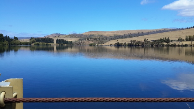
Meadowbank Lake is the last expanse of water that has been dammed for hydro power generation purposes, before Hobart.  A good, but narrow bitumen road (Ellendale Road) crosses Meadowbank Lake near its inland western extremity.

20160115_140312.jpg

20160115_140337.jpg

20160115_140356.jpg

This glorious sight is easily accessible from the Lyell Highway on the northern/eastern side of the Derwent River, or via the tiny towns of Glenora and Ellendale on the southern/western side.

Looking westwards:

20160115_140332.jpg

20160115_140329.jpg

20160115_140317.jpg

Looking eastwards:

20160115_140223.jpg

20160115_140304.jpg

20160115_140300.jpg

I have written about Meadowbank Lake before and previously included photos.  The photos in this post were taken one day after completing a walk further inland. I was being driven back to Hobart along the Lyell Highway, and then we deviated by crossing the Lake and proceeding to Ellendale to buy freshly picked raspberries and blueberries.

Only on one occasion have I passed by this Lake under cloud.  Even then, the more sombre colour of the Lake and the less vivid greens, greys and beiges of the landscape were still most attractive.  There are picnic spots either side of the Lake, and public toilets on the Lyell Highway side.  A wonderful location for solo or family visits.

Has the river of blogs dried up? Is my write up of the walks along the Derwent River over?

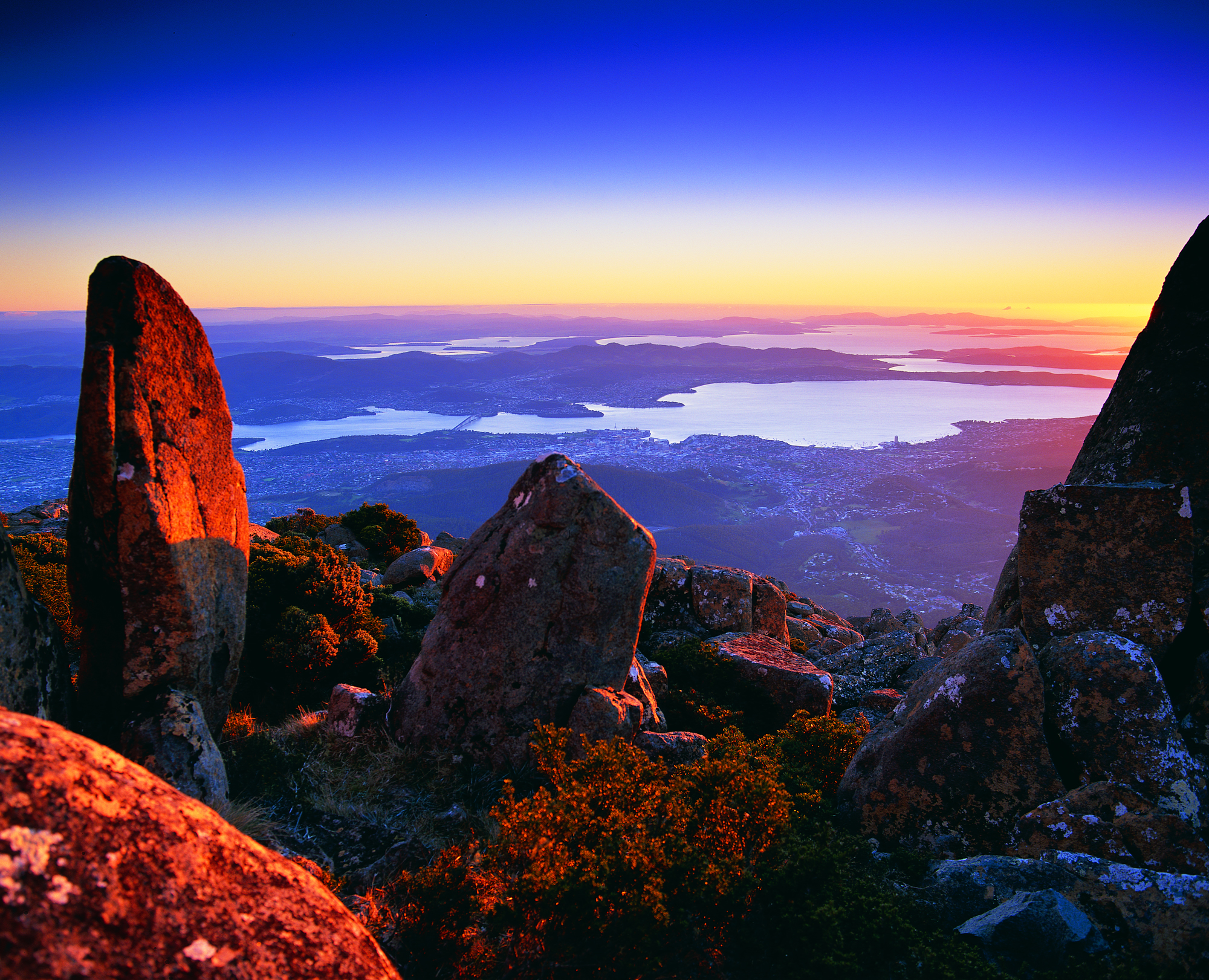
from MountWellington.jpg

 This wonderful image of ‘Hobart from Mt Wellington’ is the work of Tourism Tasmania and Garry Moore. This free photo has unrestricted copyright.

Has the river of blogs dried up?  Is my write up of the walks along the Derwent River over? The answer to both questions is no.

For a long time, blog followers have received a daily post covering my experiences after I have walked sections of the terrain from the mouth to the source of Tasmania’s Derwent River, plus my additional writings about various aspects of the social and natural history of the Derwent River.  Yesterday and this morning were a rude shock for some Australians – no blog post to absorb over the breakfast cuppas– and for my overseas followers spread across many countries, their regular daily dose arrived at many different times depending on the time zone in which they live.

Have I run out of stories to tell, descriptions to give and photos to show? The answer is a resounding no. I have much more to expose. Please be assured that you have not seen the sights of all the kilometres of the Derwent River, nor heard about all its challenges, in my blog yet.  So why the absence of new posts?

I have committed to another major project which cannot wait any longer for my sustained action. I like huge projects.

Last year I discovered that the first Tyzack in my line (3 different lines came to Australia from England in the 19th century) arrived at Port Melbourne 150 years ago this coming December.  Impulsively I decided (without research or planning just as I conceived the idea to walk the length of the Derwent River) to organise a family gathering later this year for all my great great grandfather’s descendants spread across Australia. Two family members agreed to support me –thankfully one has prepared a family tree. The Tyzack 150th anniversary organisation is now my priority, because there is a book to be put together and published, field trip guides to be developed, and much more – I still haven’t received responses to my introductory letters from most of the over 100 living descendants (almost all whom I have never heard of leave alone know) so I have a big job ahead tracking them down and getting them onside and involved.

This family event is scheduled early in October – so, if not before then, from mid-October onwards I expect to continue writing up the Derwent River walking blog stories.  Probably I won’t be able to restrain myself so that, from time to time, a post may appear.

The photo below taken by Michelle shows the eastern shore mouth of the Derwent River, Cape Direction (on the right) and the Iron Pot islet sits out within Storm Bay.

PA280012.JPG


Meadowbank Dam and Power Station

Meadowbank Dam and Power Station, as part of Hydro Tasmania’s electricity generating facilities, are located the closest of their properties to Hobart.  Access to the Dam is restricted.

East of the Dam, Meadowbank Dam Road makes the connection with the Lyell Highway but this is a locked gate gravel roadway.  Meadowbank Road is a quite different road; this public gravel road exits the Gordon River Road west of the tiny township of Glenora and travels in a north-westerly direction, but mostly not close to the Derwent River – so that it isn’t reasonable to be used as the conduit to ‘walk the river’. Before reaching the Dam, the road passes Meadowbank Vineyard and acres of vines under cultivation. However, access is restricted: there are quite a few lockable gates barring continuation to the Dam.

20160301_112604.jpg

20160301_112746.jpg

20151128_124320.jpg

20151128_125147.jpg

20151128_125433.jpg

20151128_125155.jpg

The first unit of the Meadowbank Power Station was commissioned in 1967. This was the last such operation to be built in Tasmania.  Photos are on show on Hydro Tasmania’s website and more details are available on their Fact Sheet .  The CSIRO library holds another photo taken from a different vantage point.

I am grateful for Alex driving me as close as we could go by car.

Writing up the ‘gaps’ in my walk along the Derwent River

20160104_090210.jpg

The photo shows water entering the Derwent Basin from Lake St Clair.

Despite my excitement when I reached the source of the Derwent River, I recognised there were some kilometres not yet walked or which had not had their stories told in posts on this blog.  Despite earlier misgivings and qualms about walking some edges of the Derwent River, I renewed my commitment to complete 100% of the length from the mouth to the source, and to create a blog which tells the complete story.  My future posts detail those ‘gap’ walks to the extent that I can, considering the confidentiality requirements of some landowners.

For blog followers who recently linked to my site for the first time, you may not be aware that in the earlier stages of this ‘Walking the Derwent’ project, my walks were sequential.  That is, where I finished a walk I started the next walk. However, once I reached the town of Gretna, from then on as I walked inland, my walks occurred out of sequence depending on the weather, access to the land, and a driver to take me to the start of a walk or collect me from the end of a walk.  I imagine for most of my blog readers it has been difficult in the past months to understand to understand how far away from Hobart or from Lake St Clair each walk has been.  Once I have finished writing all the walk posts, I propose to create one post which describes the River in terms of moving from one end to the other sequentially.  Hopefully this will clear up any confusions or uncertainties.

Derwent Bridge

Located 174 kms west of Hobart on the Lyell Highway, the town of Derwent Bridge extends about a kilometre from one end to the other and contains a scattering of private houses and a handful of small businesses. This tiny township takes its name from the bridge in its midst which crosses the Derwent River.  Lake St Clair sits to the north and Lake King William to the south.

I love writing Trip Advisor reviews (as Crocodillus) and after returning to Hobart from Derwent Bridge I wrote four: my accommodation at the Derwent Bridge Cabins, the food experience I enjoyed at Hungry Wombat Café , the Derwent Bridge Hotel, and the Wall in the Wilderness .  A description of these is not particularly relevant to this blog so, if you are interested, I have provided the links to my reviews with a few photographs.  I am happy to answer any email enquiries if you are considering visiting Derwent Bridge.

I stayed in Derwent Bridge for two nights (buses to Hobart do not travel every day) and every chat, communication, look that I experienced with another person was full of positive energy, good will, happiness, and this made the time pass so easily.  It did not matter whether I was connecting with the Cabin owner or her cleaner, the bar and meal staff at the Hotel, the wait staff at the café, or the owner and others at the Wall in the Wilderness, everyone was upbeat and the services the businesses provided were excellent.

In addition, I met many interstate and overseas travellers, almost all of them walkers who had been journeying either on the Overland Track from Cradle Mountain to Lake St Clair, or had been walking some of the day or longer walks in the vicinity of Lake St Clair.  The effect of continuing kind weather on walkers, the fact that their walks had introduced them to environments which they found profoundly beautiful, and their plans for future walks and discoveries were the catalyst for everyone to buzz with vitality. Infectious.

End of day departure time

I usually make a point of starting the walking day as early as possible – to walk when I am the freshest and most alert and if the weather seems fine, then to use it while it stays good (Tasmania is known for its four seasons in one day).  However on the day when I started walking along Lake King William, because I was constrained by other life commitments I did not leave Hobart until 1.30 pm. My driver Emma took me west along the Lyell Highway until a short distance before Tarraleah when we turned left and deviated onto a 16 km gravel road towards Clark Dam at Butlers Gorge.  We dodged a few speeding cars as we travelled the narrow road, when everyone screeched and slewed in the slippery gravel on crests and unknowable corners. But I refused to worry. The sky was golden blue, the bush looked clean, the temperature was perfect for walking, and my excitement grew. My driver dropped me near Clark Dam and I started walking at 4 pm.  Thankfully at this time of year the sun sets around 9pm and I knew the light of day would continue longer.  I thought a three hour walk would be sufficient to isolate me and remove me from the chances of odd bods being in the locality. Not knowing what to expect, I planned for two nights out camping before reaching the town ship of Derwent Bridge.

Near my starting point, fishermen and families were pulling boats from Lake King William behind the arc of Clark Dam.  The water was glossy blue.

20160102_155721 20160102_155854

The late afternoon was stunningly beautiful. I felt apprehensive but invigorated and ready to discover the Lake one step at a time.

Getting perspective

I discovered the following graphic on the Australian Native T-Shirts website.

For readers who do not know Australia well, note Hobart is located at the southern end of the island state of Tasmania at the bottom of the country.  Slightly east of Hobart is where the Derwent River flows out into the sea.  The source of the Derwent River is located north west of Hobart roughly in the centre of Tasmania.

Map of Aust with Europe over it.jpg

A comparison map showing Australia and the United States of America is located at the site ‘On Walkabout’.

AustraliavUSA comparison map.jpg

Finally, I found a most amusing map with multiple overlays of Australia across the world.

Australia-over-the-world

Seeing such images certainly helps me to understand the scale of our nations.

Lake Repulse Dam

Lake Repulse Map

Looking inland, Michelle’s photo shows the Lake Repulse Dam wall backed by Lake Repulse, with Cluny Lagoon in the foreground.

PA280087 Repulse dam.JPG

Looking towards Hobart, my aerial photo below shows Lake Repulse, the Repulse Dam and then Cluny Lagoon in the distance.

20151028_114913

Chantale’s photo provides an excellent overhead view of the Lake Repulse Dam. The photo also gives walkers an indication of the challenges which the landscape offers beside Lake Repulse.

IMG_3893Repulse Dam.JPG

For vehicle drivers, the Dam is reached by heading westward past the Ouse township, turning off the Lyell Highway and travelling down Lake Repulse Road. Aerial views show the roads at the Dam site clearly.

20151028_114858.jpg

The road continues across the Derwent River below Repulse Dam giving you an excellent opportunity for a close look at the structure.

20151029_151244

20151029_151355.jpg

The western end of Cluny Lagoon, located a little downstream from the Repulse Dam, is stunning.

20151029_151317.jpg

To walk further inland around the Dam wall and then along the edge of Lake Repulse, the following photograph gives an indication of the landscape to be encountered.

20151029_151400.jpg

Michelle’s photo below shows part of the 8 km long Lake Repulse is a handsome water storage area.

PA280088Lake repulse.JPG

Historical information can be read, although I cannot vouch for the accuracy of the information.  Hydro Tasmania provides details and adds a technical fact sheet.

The complex that makes up Wayatinah – posting 2 of 7

Wayatinah Lagoon

Having taken a turn off Long Spur Road, Andrew and I were the only visitors to this misted expanse of water on the 29 October 2015, the characteristics of which were almost total silence and an immense sense of quiet peacefulness.  I felt privileged to stand in such a serene environment, and smell the clean fresh air.

20151029_084702 Liapootah PS on hill in distance.jpg 20151029_084713.jpg 20151029_084742.jpg 20151029_084845.jpg

Watch the video.

A boat ramp, away from the infrastructure that accepts the water to be transported to the Wayatinah Power Station, ensures the safety of anglers from any unexpected water level changes.

20151029_084906.jpg 20151029_084829.jpg

Michelle’s aerial photo below gives some indication of the size of this Lagoon, and the way the river bed snakes away from it amidst dense vegetation heading towards Hobart.

PA280095 Wayatinah Lagoon.JPG

Where is the source of the Derwent River?

This question was on the minds of the new settlers to Van Diemens Land in the early 1800s.

In 1835 George Frankland, Surveyor General to the government of the time, organised a ‘search’ party to locate the source. After the expedition he wrote a report for despatch to the ‘mother country’, England.  The brief text has been published as The Narrative of an Expedition to the Head of the Derwent and to the Countries bordering the Huon in 1835.  The small book was reprinted by Nags Head Press for the publisher Sullivan’s Cove in 1983.

No description exists of how Frankland and his party travelled inland until they reached a property or area then known then as Marlborough (now known as Bronte) in the Lake country, located west of Lake Echo and directly east of Lake St Clair by over 30 kilometres. Marlborough was a probation station for North American prisoners in the 1830s/40s.

Map of probation stations including Marlborough

The map above can be seen in the story: ‘They left Jefferson County forever…’

The Marlborough district was discovered by Surveyor Sharland who also found Lake St Clair, in 1832, only three years before Frankland felt compelled to find the source of the Derwent.  It seems Sharland did not realise it was the Derwent River that flowed from the southern end of Lake St Clair. Further information can be read in G. H. Stancombe’s paper Notes on the History of The Central Plateau.

The Lyell Highway, according to the Highland Lakes Settlement Strategy has been known as the Marlborough Road where it runs westwards of Ouse and towards the area around Bronte.

Information, which is totally irrelevant to my writings about the Derwent but nevertheless interesting, concerns an earthquake near Marlborough that was recorded in The Courier, a Hobart newspaper on 25 April 1854. Thomas Bellinger reported ‘I beg to inform you of a very strange occurrence on the evening of the 24th of March last. A shock like that of an earthquake was felt in almost every part of the Marlborough District. Two shepherds were gathering sheep the other day and discovered the cause of it.  I went to the place yesterday: there has been some fearful volcanic eruption, rocks of enormous size have been driven about, the face of the earth appears to have been hoisted in the air and pitched surface downwards. I cannot describe to you the appearance, but if you will come up I am sure you will be highly gratified – the distance is about ten miles from this.’  I have no information about where Thomas Bellinger was writing from but I am curious to hunt out the location of this upheaval.

After that information detour, let’s go back to the expedition to find the source of the Derwent River.

Following a ‘difficult journey from the settled Districts’, all members of George Frankland’s party assembled at Marlborough on the 7 February 1835.  The record shows that George Frankland did not follow the edges of the Derwent, rather he crossed the Nive River (which empties into the Derwent River much further south), then travelled north-westwards. Initially densely forested hills stymied progress with horses, and then the boggy plains ahead slowed him down.  He continued generally in a westward direction and after almost five days, found Lake St Clair; ‘we suddenly found ourselves on the edge of a beautiful Lake in the heart of Scenery of the most picturesque Character’.  After further walking around parts of the lake, Frankland reports ‘It was a fine summers day and the Air was so serene that the surface of the Water was scarcely ruffled but the sandy beaches bore evidence of the Lake being at times as rough as the Sea. I will not here dilate on the extreme beauty of this scenery as it might be considered out of place in an official report, but … I feel it difficult to avoid expressing the impressions of delight which were inspired by first discovering of such a romantic Country…’

On the 14th February, Frankland despatched two of his party to return to the source of the Derwent and follow it downstream on the left bank while he set out to explore the country on the right bank.  Both parties walked across open plains where Lake King William now fills the area.  They reunited the next day.  One of the party, a Mister Calder was despatched to continue along the edge of the river until he met the entrance of the Nive, which he successfully achieved (although details are absent).  Meanwhile Frankland tried to continue following after Calder but was only able to proceed for 3 miles. ‘At that point we plainly perceived that the Country had … become such a thick forest that to take the horses any further was out of the question.’  The result was that Frankland split the party further with the horses taking an easier route to Marlborough.

On their first day trying to walk the edge of the Derwent, Frankland recorded ‘This day was consumed by a laborious march of two miles through a most obstinate scrub – and we bivouacked on the steep edge of the Derwent after wading for a considerable distance through the torrent, up to the middle, as the easiest mode of travelling.’  The forest is as dense in 2015 as it was then, so regular blog followers can appreciate why walking some sections of the rest of the way to Lake St Clair concerns me.

At this point Frankland was for giving up. ‘On the 18th February I determined on leaving the Derwent and accordingly struck away to the N.E. The forests continued depressingly thick – but by dint of labour we accomplished about four miles this day’.  Only four miles in a day for strong men!  What chance do I have of walking this part quickly or easily?

A couple of days later Frankland reached Marlborough and from there he set off to cross the Derwent River and explore the Huon River area further south.

Thank you Andrew for alerting me to this report and for the loan of the book.