Tag Archives: Tasman Bridge

Not for human consumption

Today’s ABC News Online gives us the headline suggesting an exciting story – “Amateur dive photographer shares snaps of Hobart’s hidden underwater world”.

We are told “Under the surface of the River Derwent you’ll find an otherwise hidden and surprising colourful world of marine creatures.” Accompanying the story are photos of divers and underwater creatures.  Quite startling is the beauty of what divers can see. Wonderful.  The gorgeous photo of a crayfish by Millie Banner attracted my attention – who doesn’t love eating a crayfish. However, “… heavy metal levels in the river make them not safe to eat.”  So please do not go down deep seeking a feed from the waters under the Tasman Bridge.  Besides the river currents might sweep you out to sea.  Maybe.

The Derwent River at night

Tasmania’s bush, its coast and urban areas offer a photographer’s paradise at all times of day and night across the four seasons.

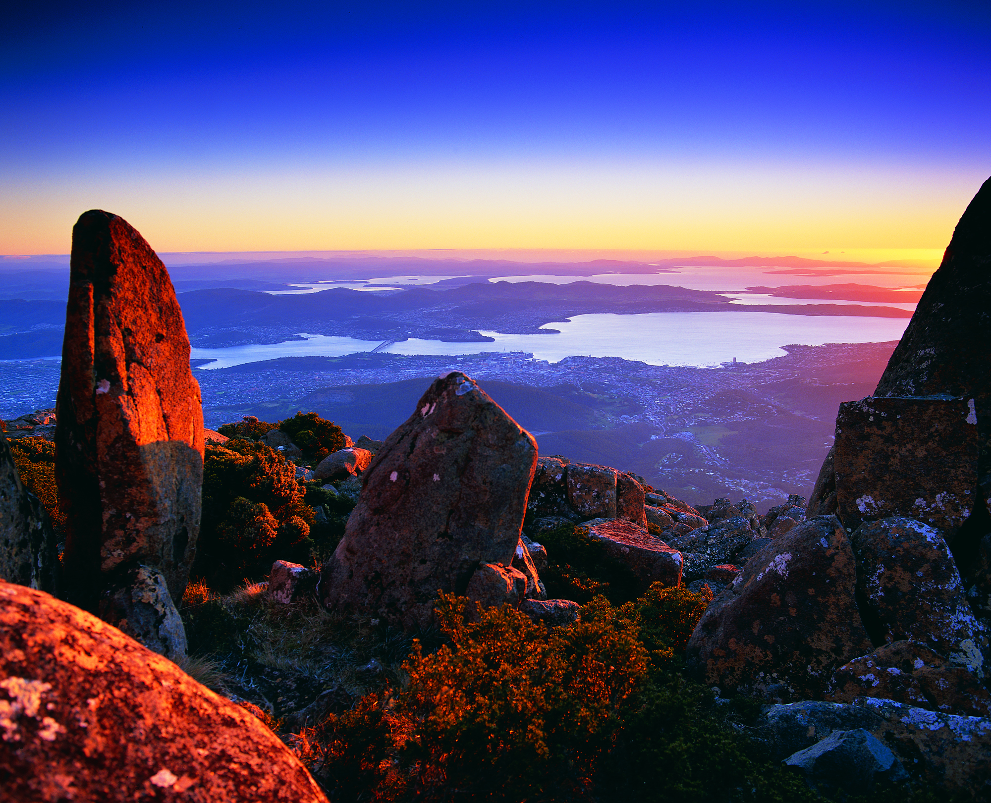
This Amazing Planet  is one of many blogs that show spectacular photographs of Tasmania’s flora, fauna and landscape. Go to Nightscape-Hobart for a stunning visual treat. Enjoy looking at part of the glorious Greater Hobart Area, at night, photographed from on top of Mount Wellington. Between the two sides of the city, the rich blue Derwent River passes on its way to Stormy Bay and then the sea. The brightly lit Tasman Bridge can be seen to join the two shore lines.

Another revision: naturally therapeutic images from stages 7-10

I can’t help myself. Having reviewed my favourite images from the first half a dozen stages of my walk along the Derwent River, I felt compelled to continue looking through my collection from the subsequent walks.  I have chosen photos showing aspects of both the natural and man-made world and I believe all will prompt thinking about the Derwent River, Hobart and its suburbs, and the natural environment. My selection of the images with the most memorable impact for me, from stages 7-10, are given below.

20141031_094126

From the eastern shore looking northwards towards the Bowen Bridge, with a couple of black swans on the river.

20141031_100200

Two plaques ‘opened’ by two great Australian prime ministers near the Bowen Bridge.

20141031_104822

The rusting raw-edged remains of a ship, the Otago, at Otago Bay.

20141031_113132

My enjoyment of any family’s black sheep.

20141031_123000

Heading into Old Beach and gradually leaving Mount Wellington behind.

20141031_132519

The gloominess of the approaching storm when I reached Old Beach.

20141111_092342 20141111_092805

The pleasures of well-made pathways, thanks to local government.

Green Point from new Old Beach

Looking northward across the Jordon River to Greens Point.

20141111_103700 20141111_121906

The glories of native flora. In these instances, it was blooming wattle and a spectacular stand of eucalyptus/gum trees which attracted my attention.

20141111_120752

The remains and the signs of a burnt out car on a back track.

20141111_130523

Knowing that it is still possible to have a laugh when walking.

20141111_131133

Arriving at the Bridgewater Bridge.

20141111_134311

Walking on the western shore of the Derwent River for the first time during this project.

20141125_095438

The house of one of first European settlers, James Austin, at Austins Ferry.

20141125_115047

At Dogshear Point, walking around the Claremont golf course, with the thwacking sound of hit balls crossing the greens.

20141125_110906

Reaching Cadbury’s chocolate manufacturing factory in Claremont.

20141125_143454

The hand-hewn rustic style seat near Connewarre Bay.

20150109_074126
Passing MONA somewhat camouflaged as it nestles into a tiny hill against the Derwent River.

20150109_081644

The mosaics along the foreshore.

20150109_101243

The jumble of boats and boat houses at Prince of Wales Bay.

Hoon tyre marks

Road mark making in Lutana.

20150109_132008

Cornelian Bay’s oil tanks up close.

20150109_153103

The Tasman Bridge.

20150109_155515

The circus had come to town.

20150109_161747

The emptiness of an arena of stands waiting to be filled during wood chopping competitions.

20150109_161339

Reaching the ‘end of the line’ on arrival in Hobart city.

Another Derwent River transport service may be disappearing

A few days after I wrote the post about the end of the water taxi business on the Derwent River indicating my sadness for such short sightedness by the community and government agencies, I have discovered another sad tale. It was with horror I read the story at http://www.news.com.au/national/tasmania/tasmanian-air-adventures-in-liquidation/story-fnn32rbc-1227328240883.

Tasmanian Air Adventures, despite being incredibly popular and forever in the air over the Derwent River, has not been able to recoup its establishment expenses and get into a profit position. The result is the owners have run out of money and the business has gone into liquidation.

The outcome has been immediately clear to me. I had become used to seeing, many times a day, the water planes lifting off from the waters of Salamanca Cove in the centre of Hobart, and flying along the Derwent River.  And now only seagulls fly where once flew entranced tourists and locals.

In a city which has one of the best waterways in the world, Hobart is missing the opportunity which any other city in such a location would be grabbing and making work.  Blog followers keep telling me how much they enjoy my photos and information about what can be seen at the shoreline of the Derwent River.  I feel sure others would feel the pleasure which the river can offer, as well as appreciating its functionality to transport them hither and thither.

Years ago the Tasman Bridge was accidentally knocked down and immediately people became used to ferrying across the Derwent River/Harbour to and from work. The concept that the river is a lifeline and a connector of peoples; one which wants to be used, seems not to be factored into any level of serious government thinking.  Meanwhile valuable resources are used to create more and more city carparks.  Say no to car parks, I say. Say yes to ferry and air travel along the river.

Chatting with a traveller

On Stage 14 of my walk from Granton to New Norfolk by the Derwent  River, a car pulled off the road ahead of me at Sorell Creek. The female driver sat motionless. I plodded on and, as I walked past the car, she wound down her side window and asked for help.  A farmer from inland NSW, she and her daughter were staying temporarily in Maydena (http://www.discovertasmania.com.au/about/regions-of-tasmania/hobart-and-south/maydena), a small town on the way to Strathgordon in south western Tasmania – a town where our shy native platypus can be seen in the fast flowing Tyenna River, the waters of which eventually flow downstream to help keep the Derwent River level high.

While her husband worked that day, she decided to take a drive in the car and look around to see more of the country.

When we met, she wanted to find a route to the convict penitentiary at Port Arthur (http://www.portarthur.org.au) without needing to navigate busy Hobart city streets. Her only map was a small abbreviated tourist map of Tasmania that showed the main highways and a few towns. I dragged out some of my maps, and we chatted amiably while many options were considered.  Through these conversations I was clear that our road signage is designed for those who know where they are going, and not always for those who don’t know the terrain.

The thought of encouraging her to take the East Derwent Highway, come out near the Tasman Bridge and then need to cross three lanes of traffic immediately, filled me with dread.  When you are driving and unsure of where you are and how to get there, many signs and endless traffic can be disorienting.  I felt sure she would find herself in suburbia and never understand how to extract herself from there in order to be on her way to Port Arthur.

To take the Midlands Highway by crossing the Bridgewater Bridge, and travel towards Oatlands to find a cross country route, also seemed impractical.  Once off that highway, narrow winding roads lead eventually to Richmond but this would not help her easily to get onto a road leading to her destination, without much more direction asking of locals.

We settled on the option where she would continue along the Lyell Highway, drive along the Brooker Highway towards Hobart city, before taking the left hand exit to the Tasman Bridge near Hobart, and then driving across the Bridge.  I hope the blue airport symbol was posted liberally during that journey.  If she followed that symbol, then once at the final roundabout to the airport she knew to drive straight on.  We didn’t exchange contact details so I continue to wonder if she found Port Arthur without getting lost and without losing time.

At 12.15pm we parted company. I was glad to have had someone to talk with. Besides, she had been considering walking (http://www.bicentennialnationaltrail.com.au/) from the north to the south through Australia (a mere 5330kms from Cooktown in far northern Queensland to Healesville slightly east of Melbourne, Victoria).  I wish her all the best.

Finding information – ‘time walk from lindisfarne to Hobart city’

Today on my blog statistics page, I noticed someone from somewhere entered into their search engine, the following words: time walk from lindisfarne to Hobart city

I understand travellers and locals want to know this type of information but websites have not been set up to help.

Based on my knowledge, and for an average strolling style walk, I guess the time from Lindisfarne to the Tasman Bridge would be no more than half an hour (only 2.1 kms from Lindisfarne’s Simmons Park to the Bridge), allow 20 minutes to negotiate your way across the bridge on the narrow pedestrian path with cyclists and pram wielding mothers, and then on the western side into the city the walk takes about 20 minutes.  This makes a total of approximately 1 hour and 10 minutes to complete the walk. At the beginning and end of the day, there is a constant stream of walkers and cyclists making this trek to and from work in the city.  A healthy and pleasant way to live a life.

Video stories and the Derwent River

Last week I bussed 20 odd kilometres down to Kingston and participated in a workshop, organised by ABC Open (go to https://open.abc.net.au for written and video stories from around Australia), about making video stories with tablets and IPads. Since then, using my Samsung tablet, I have taken a series of video shots beside one section of the Derwent River. To tell a story, different video shots are needed for linking together. At the end of this week I will return for a second workshop to help me edit different shots together into a coherent story.

I would like to share some of what I have learnt so far.

Firstly, we should always make videos using the ‘landscape’ rather than ‘portrait’ orientation. Once I was alerted to the fact that the landscape orientation typifies movie screens, televisions and computer monitors, I understood this was the preferred way for our brains to operate (our eyes ‘sweep horizontally across the landscape’ for survival more often than up and down).  This morning I looked at an online news story which included a short video presumably taken on a smart phone by a public bystander to the event. The film was oriented in the vertical portrait direction so that when screened on my computer monitor, two lumps of black either side of the tall narrow image made it difficult to ‘read’.  So I have learnt that lesson.

Other learnings included: the idea that I should not move the tablet to record the video, rather I should swivel my body from the waist. Doing so creates less shudder movement resulting in clearer videos. I should never use a zoom function when it is an option on a device, rather I should take a series of sequence shots then edit them together.  Not everything has to be in focus if a story is being narrated.  Aim to record a series of peak moments in order to compress time. Beware of recording with the device directly face down because devices can revert to the portrait orientation once in the position of being parallel to the ground – therefore, I must remember to keep an angle on my tablet in such a situation.

We were informed that the journalism standard is a 5 shot sequence where each video shot is taken from a different angle or distance.  Now I watch news broadcasts differently and can analyse the variety of shots. We were recommended to make each shot about 8-15 seconds in length to provide sufficient information for editing. In addition, we were counselled to be patient as we record, in case there is an unexpected (and interesting) change in what we are recording.

At the end of the workshop’s theory session, including watching a number of good and bad videos available on the internet, I started to plan my story.

I was urged to create a story associated with my project to walk along the Derwent River and, while this idea sounds like it should be easy for me to develop, it has not been.  In fact, I have found it quite difficult to determine a story line, create a story board of the shots which will be woven together and then get the best mini videos to demonstrate each part of the story.  When I recognised the hundreds of stories associated with my walks, I realised that it would not matter on which story I worked, all I needed to do was make any choice and then get on with it.

For the past couple of days, I have made a series of brief video shots involving the Tasman Bridge which spans the Derwent River. On my way home, I recorded the following 9 seconds of traffic streaming along and over the Bridge. This video doesn’t fit with my story so I have inserted it unedited.  The video shows traffic on the Tasman Bridge with Mount Wellington in the background, viewed from the Rose Bay High School overpass.    See the video at https://vimeo.com/121886583

I am now ready for the workshop on editing to create a visual story.

Before my walk along the Derwent River last Tuesday

As my bus from home into Hobart city passed over the Tasman Bridge before 7am, I looked down onto a dozen or so rowing boats slipping along the Derwent River. The wedges that their passing craft made were the only patterns on the still surface of the River.

The morning was suffused with golden light forewarning the rise of the sun over the hills.  The few wisps of cloud in an otherwise blue sky were coloured silvery pink.  The temperature was a brisk 8 degrees, but I felt clean and alive prompted by such a vital looking day.

Once in the city, I walked to Franklin Square ready to wait for the next bus to Blackmans Bay, my starting point for Stage 13. While waiting, I walked through the park and admired the grand symmetrical fountain splashes around a large bronze sculpture of the eminent 19th century Rear Admiral Sir John Franklin.  Overhead, I watched a squawk of Sulphur-Crested Cockatoos, with their wings lit by the first rays of sunshine, flying as a family.  Street cleaners were clearing rubbish bins and pathway surfaces.  Very few other people were out and about in the centre of the city (people were being active in the suburbs before commuting to work in the city a while later).

The large public chess set had been set out and was ready for play.

20150224_071013

As the sun struck the Treasury buildings at one end of Franklin Square park, clusters of fat seagulls (Silver Gulls) were nipping at early rising insects across the grass lawns.

Metro bus number 84 departed at 7.17am. By 7.33am we had climbed up and travelled along the Southern Outlet and were passing through Kingston. This gave me a clear cut side view of majestic Mount Wellington.  Every rock was hard edge and clear. The air was so clean.

At 7.41am I stepped off the bus at Wells Parade in Blackmans Bay, the location where I had finished Stage 12 of my walk.  The final walk to the mouth of the Derwent River was about to begin.

Huon Quays has been purchased

On Stage 10 when I walked to the Hobart Regatta Grounds after passing under the Tasman Bridge on Stage, I stopped to have a look at the cluster of old white painted buildings, which had started their lives as a navy depot.

20150109_160439

These buildings, now known as Huon Quays, have been sold to Tasports.  Read more about it at: http://www.themercury.com.au/lifestyle/tasports-snaps-up-prime-huon-quays-waterfront-site/story-fnj64ocs-1227202042732 I wait with interest to see how this heritage site will be developed.  I hope the development will be sympathetic to its history and the surrounding environment.

Starting out from Hinsby Beach and walking south to Wandella Avenue – Stage 12

I left home in Bellerive on the eastern shore of the Derwent River before 7am while the morning was cool and the light was soft grey. By the time my bus into Hobart city was travelling over the Tasman Bridge, the sun had hit the top of Mount Wellington, the sky was blue, and the day promised to be sensational.   The dramatic circus tent on the Queens Domain was being dismantled. People on the bus seemed to be dozing. Yet outside the bus, I wondered at the stunning crispness of shadows and sunlight causing windows to sparkle.  The look of the day made me feel like I was sparkling.  But my eyes were wide open.  Waiting at the bus stop at Franklin Square for a bus headed towards Kingston but passing through Taroona,  all I could think was ‘glorious, glorious, glorious’.

With few people on board, the trip to bus stop 30 in Taroona (the one where I finished in Stage 11) only took 22 minutes and then I was out in the fresh air on the Channel Highway at 7.52am. Gulls calling. Gardens were flush with sunflowers, roses, agapanthus, wandering pumpkin plants, lavenders of all types, and flowering gum trees.  All overlaid by the sounds of bush birds flitting here and there.

By 7.58am I had walked down Hinsby Street and reached the top of the walkway leading to the Hinsby Beach.  I could hear the shushing of the soft waves along the beach and glimpse a tiny bit of water at the end of the shady path.

20150202_075819

I could see the Alum Cliffs through the trees.

20150202_075858

A swimmer was leaving the water as I clicked a photograph. When I registered his angry body language, I realised I had been feeling the place without really seeing.  Of course my finger on the tablet’s camera clicked mechanically without seeing or feeling – but featuring photographs with him was not to his liking. I immediately claimed to be photographing the Alum Cliffs at the end of the beach and promised not to blog his picture.

20150202_080143

I guess the swimmer was not used to sharing the beach with anybody else that early and could only repeat rather manically, ‘you must come in’, ‘you must come in’ as he gesticulated towards the water.  I was thickly dressed from neck to toe and already wearing my sun hat.  ‘Going in’ was not in my plan.  I continued along the beach. A little later on a path, I took the following photo – I hope you can understand that getting undressed would never have been an option.

20150202_080640

At 8.05am, at the end of Hinsby Beach, I looked back for one last sea-level view of Hinsby Beach.

20150202_080405

I reached a stairway with rails and walked uphill until I seemed not to be on a clear track.

20150202_080359

When you read further below you will realise the photo above does not show the start of the track which I should have taken.

Very soon I arrived at a gully with a small trickle of water passing downhill. I chose not to cross by balancing as a gymnast on the dead tree trunks that criss-crossed it. Instead I simply walked easily down, stepped across a few rocks and walked up the other side.  Before long it was clear I was fenced in and that a proper dirt track passed on the other side of the fence. The fence was elastic so I swayed over it rather dramatically without falling off and down the cliff on the other side of the track. When I righted myself and looked back along the track which I hadn’t known existed, three women and a dog stood very still, their mouths agape. ‘Are you alright?’ they chorused. ‘Yes’, I assured them as I smiled.  Some moments I wonder if I am losing my once good judgement.  ‘But where have you come from?’ I asked with a puzzled wrinkling of my forehead. ‘Where did you find this track?’  Apparently, if I had bypassed the stairs and track I had chosen and walked around over the rocks of Hinsby Beach a little further, the real track started there.  Time for the installation of a few signs!

This ‘new’ track was fine.

20150202_080456

Although there were occasional diversions across the track.

20150202_084019

The view back towards Hinsby Beach was clear.

20150202_082252

The time was 8.22am as I offloaded my jacket, smeared sunscreen across exposed parts of my body and continued walking along the track until it extended up into a suburban street.  At 8.25am I turned left into Wandella Ave, wandered along past houses for a while, could not see any further tracks back to the Alum Cliffs, talked to a local who did not think there was one and recommended that I should walk up to the Channel Highway and continue southwards on that road.

Not to be defeated, I retraced my steps down the original pathway until I discerned an old disused track that seemed to continue along the Cliffs.  I walked it but casual inexperienced walkers and those walking alone absolutely should not. Incredibly unsafe in just about every way.  I didn’t fall nor receive injuries but there were so many ways and places I could have damaged or killed myself on that route.  I won’t relay all the details of that walk except to say that the views across the Derwent River though the trees were grand. Blue Wrens darted around me through the bush. Waves pounded against the Cliffs, and I could hear the roar of waves crashing on distant beaches.  Because photographs flatten the vistas, the ones I have taken do not present the feeling of isolation, steepness nor roughness of this non-track.  But it was incredibly beautiful and I am glad to have seen that landscape.

20150202_085324

I started this diversion at 8.37am. After following a collapsing path (although parts were good), I managed a deep descent into and an ascent out of an unnamed gully by 9.12am, rounded an extensive private house, talked with the house owner about the future of tracks along the Alum Cliffs and the non-availability of any tracks passing his house (which stood on the very edge of the Cliff) around 9.25am, and walked down and around the very long winding private driveway over a trickling creek, I reached suburbia again at 9.35am – the same point on Wandella Ave I had been earlier in the morning. I had completed a loop. Certainly I had been close to the Derwent River more than most but I had not advanced along the River.

The first photo below shows the house I climbed up to on top of the cliff after descending into a gully, the waters of which plunged over a rocky edge to the River.

20150202_084704 20150202_085446 20150202_092605

I recommend that all evidence of the existence of the disused track should be eliminated.

Impressive swim down the Derwent River on Saturday

The air temperature didn’t rise above 20 degrees C and while I do not know the Derwent River’s water temperature, I imagine the swim was invigorating to say the least.

On Saturday, a Massachusetts (USA) marathon swimmer survived an overarm feat that nobody apparently has completed for 40 years. He swam from New Norfolk, 19kms by road west of Bridgewater Bridge (the Bridge I reached when walking a few Stages ago), southwards until he reached the Tasman Bridge which is the last bridge across the Derwent River before the mouth of the River. Dan Curtis began ‘The Big Swim’ at 6am and just on 10pm he reached his destination.  Photos of the man (http://dailynews.openwaterswimming.com/2015/01/dan-curtis-to-take-on-big-swim-after-39.html) indicate he is no spring chicken so I am very impressed.  This is another wonderful example of having a goal, giving it a go, then finding out whether success is possible.

From the Tasman Bridge to Hobart’s old navy depot

Walking from Cornelian Bay towards the city of Hobart and under the Tasman Bridge was something I had not done for a few years. In the past I could see signs of homeless people using areas under the bridge but not this time. I had a sense that some sort of industrial bridge work was in progress and that the authorities would be around and about here frequently.

20150109_152735  20150109_153103

From the Tasman Bridge into the city I remained on the bike path where I was continually vigilant for cyclists riding fast and hard – to help them and to help myself, I stayed firmly to the left of the path so they could whip by.

20150109_153134

I looked over Ross Bay and across the Derwent River to the shores of previously walked suburbs such as Montagu Bay and Rosny.

 20150109_153023  20150109_153050

I looked down the river and could vaguely see the isthmus joining the South Arm peninsula to the mainland of Tasmania; an area where I walked during Stage 1 and 2 of my walk along the Derwent River.

20150109_153056

I continued along the bike path heading towards the old navy depot near the Hobart Regatta Grounds.

20150109_154621

I passed two large tug boats resting at their berths.

20150109_154926

It did not seem to take a long time and much walking before I could look back and see the Tasman Bridge was growing considerably smaller again.

20150109_155228

Uphill on my right, occasionally through the trees I could glimpse parts of the 19th century sandstone block Government House.  Further information about the House can be read at http://www.govhouse.tas.gov.au/. The flag was flying high indicating the Governor was in residence.

20150109_153126  20150109_153944

Tasmania’s new Governor is our first female Governor. Her Excellency Professor The Honourable Kate Warner AM, Governor of Tasmania was sworn into service on 9 December 2014.

At 3.55pm I had arrived at McVilly Drive which crossed my path. On the rise to my right, grandiose circus tents filled my view and I could hear a performance was underway with the booming voice of a ringmaster surrounded by pumping pop music.

20150109_155515

I discovered a family of powerful Clydesdale horses corralled by electric wire fences and comfortably grazing on the lawns around the other side of the circus.

20150109_162654

A different boom startled me. I realised a large ship somewhere close was blowing its ‘trumpet’. I was close to the main Hobart port. A seaplane flew overhead presumably with a load of tourists enjoying the view.

I turned left at McVilly Drive and instead of walking down to the water where I could see there would be no further access southwards, I chose to walk to the right along the metal sleepers of the disused railway line behind a cluster of old white painted buildings, which had started their lives as a navy depot.  Once past the back of the old buildings I walked downhill, watched a cluster of fishermen not yet catching any fish, and turned left and walked northwards along a road leading to an entrance to the navy depot.

Currently known as Huon Quays and located at 17 McVilly Drive, Hobart, you can refer to photographs at http://www.realcommercial.com.au/property-land+development-tas-hobart-501343663 and see that this set of old buildings could be sold for a hotel development.  First built in 1914 as a naval depot, the building includes a ‘Drill Hall’ (major function centre) ‘Club Huon’ (19 rooms for backpackers), ‘Commandants House’ (residence, bar and lounge) plus offices, amenities block, store rooms and night quarters. Originally this was the home port for the navy ship HMAS Huon and the drill hall was constructed for navel cadets.  According to http://www.soldierswalk.org.au/walk_domain.html, the site “served as an important training centre and home dock for a number of small naval vessels until the base was de-commissioned in 1994. The oldest remaining buildings date from 1912-13.”

What I saw on my walk was:

20150109_160405 20150109_160435 20150109_160439

I realise that with increased visitor numbers to Tasmania, accommodation can be difficult to find at times of festivals, special concerts and important sporting events, and that therefore Hobart needs more hotels. However the thought of this rather pretty building being demolished to make way for a less interesting building worries me.  But perhaps the new owners might create something in keeping with the site’s heritage. I will watch with interest.  I left at 4.07pm to continue my walk.

Pushing on to the Tasman Bridge

Leaving the delightful Cornelian Bay boatsheds behind, I followed the gravel track almost until I reached the Botanical Gardens at which time I walked up a slight rise and joined the concreted bike and pedestrian track that extends from Hobart to Claremont.  I could have walked from Cornelian Bay entirely on that pathway but it is not located as close to the waters of the Derwent River as the very smooth and wide gravel track.

20150109_150213  20150109_150750

I enjoyed looking back to see markers of where I had walked such as the white oil tanks at Selfs Point

20150109_151815

and across the Derwent River to Lindisfarne and Rose Bay which were tramped in an earlier stage of my walk along the Derwent River.

20150109_150743

The atmosphere on the track was gentle with the breeze softening through the casuarina trees. The sound of road traffic somewhere above me was audible but did not intrude in such a way that the sound of the water lapping onto the shore could not be appreciated.

Gradually, the Tasman Bridge seemed to be growing larger the closer that I walked towards it.

20150109_150822

The photos below show the bottom entrance to the Botanical Gardens.

20150109_151715  20150109_151834

The bike path crossed to the left over the disused railway line opposite the entry to the Botanical Gardens at Pavilion Point. I followed that way at 3.15pm in order not to stay on the main road with mainstream vehicular traffic and no footpath.

I could have followed the tracks of fishermen through the grasses and scrubby trees to the foreshore and then walked through a weedy parkland and past the Mercantile Collegiate Rowing Club building. I did not take this route because it looked like the length of it was fenced off and I doubted I would be able to get back onto the road or path near the Bridge. My feet were sore and I was aiming to reach Hobart – I did not want to retrace my steps, and therefore I took the easy way out and stayed on the road.  However, once I reached the Rowing Club building I could see that an exit would have been easy because there was no fence or gate on the other side of the building.  It seems that the foreshore would have been easily walkable.

20150109_152513  20150109_152721

Until I reached the Tasman Bridge I walked on the edge of a road and shared this with cyclists, a jogger and the occasional van and car.  At 3.30pm I reached the Tasman Bridge and rejoined the bike path.

20150109_152804

Visiting Cornelian Bay

With Selfs Point behind me, I could see the Cornelian Bay cemetery through the locked gate and up above the crumbling cliffs to my right.

On closer inspection, I was happy to discover part of the fence near the gate had been peeled back for pedestrians like me.  Through I went.

Twenty or so metres below, over mown grass, I reached a walking track at 2.20pm. This gravel pathway, with its strong views of the Tasman Bridge, wound around the hill and down to Cornelian Bay and its narrow beach, with a view of Mount Wellington in the distance. Exceptionally pleasant and other walkers were also enjoying the experience.

20150109_142127  20150109_142311  20150109_142604  20150109_142844

Walking along the shore of Cornelian Bay is a calming experience.

20150109_143849  20150109_143918

By 2.36pm I was sitting outside the Boathouse Restaurant not far from the public toilets, a free gas BBQ area and a kid’s playground. I stopped to eat some more of my preprepared lunch. The day was cooling and so I did not take the opportunity to buy an icecream like some of the other many visitors to this lovely area. They were feeding ducks, walking their dogs, playing, meandering, and eating. A very comfortable existence.

At 2.44pm I continued walking around Cornelian Bay by choosing leftward tracks that passed empty oyster shells bleaching on the shore, and moved toward a row of attractive boathouses.

20150109_142753  20150109_143834  20150109_144806  20150109_145107

These are the most expensive boathouses in Tasmania and I noted one was up for sale (if you have a large pocket full of money and are interested, go to http://charlottepeterswald.com.au/property/36-cornelian-bay-new-town-00161878).  Another website shows a boathouse which sold recently: http://www.realestateview.com.au/Real-Estate/boatshed-cornelian-bay-new-town/Property-Details-sold-residential-6528149.html.

I reached the end of the row of boathouses at 2.55pm, and walked across a tiny beach to meet with the continuation of the track southward. This spot was idyllic and secluded. A couple of locals were cleaning the barnacles off the bottom of their dinghy.  Everything was peaceful.

20150109_145335

Lutana

Having made the decision not to visit the industries that hug the edge of the Derwent River during my Stage 10 walk, I turned right and walked down hill along Derwent Park Road on the footpath passing the Veolia recycling plant, turned left at Cox Ave then right at Furneaux Avenue. This route gave me the opportunity to surprise a friend by dropping in unexpectedly.  Two hours later after wonderful cups of tea I ventured out again.

There are many suburban routes over the Lutana hill and I chose to walk up O’Grady Avenue (which made me think of one of Australia’s elite cyclists Stuart O’Grady who was a major player in Le Tour de France and other international races, but has now retired) turned right into Bowen Ave, left into Michael St, left at Lennox, and right at Ledwell St.

This route presented superb views to the north and the south.  Views of the suburb of Moonah to the north and north west included:

20150109_123334  20150109_123338  20150109_123611

To the south and east, the views included Bedlam Walls and East Risdon State Reserve on the other side of the Derwent River.  This gave me a perspective I never had when walking on that side of the River in an earlier stage.

20150109_123854  20150109_123912  20150109_124333

There came a point where I could see the Tasman Bridge in the distance (staggering now to see it was so far away and yet I walked under the Bridge and continued onto Hobart later that day).

Towards Tasman Bridge

Landmarks further south include large white fuel tanks. These were clearly visible from a number of vantage points as I walked over Lutana.

20150109_124401  20150109_130014

I continued downhill on the southern side, until I crossed Ashbolt Crescent at 12.45pm. I was surprised to find a golf course designed to flow on either side of Reece St, a normal suburban street that I walked down to reach Risdon Road.

20150109_124651

The visual highlight of this part of the walk was the graphic nature of tyre marks on the streets from hoons doing wheelies and other mark making with their vehicles.  I liked looking at the result and have made this image my computer screen background for the moment.

20150109_124407

Once down onto Risdon Road I turned right and followed it parallel to New Town Bay in a westerly direction towards New Town Creek. About 1pm I was passing the Waterfront Lodge, motel accommodation which I did not know existed.

.Waterfront Lodge on Newtown rivulet

Five minutes later the Apex Park was on my right and on the other side stood the Culloden Hot Take Away Store with the glorious backdrop of Mount Wellington.

20150109_130559

When I stood and looked south, I could see a few tombstones of the huge Cornelian Bay cemetery between the trees on the distant small hill. In this photo, a smidgin of New Town Bay appears in the left of the photo through the vegetation.

Cornelian Bay cemetary from Lutana

At 1.07 I reached the junction of Risdon Road with the Queens Walk,where a bridge crossed New Town Creek.