Tag Archives: Tasmania

The Derwent River in 1958

Recently a friend sent me a link to an extraordinary 9 minute film that was made in 1958. The film is based around New Norfolk, a town located approximately 35 kms west of Hobart. The Derwent River bends around the edges of the rural town that is now built up on both sides of the river.

Enjoy watching the film ‘Valley of the Derwent’, produced by the Tasmanian government, here. Please bear with the excruciating sound of the music so you can listen to the 1950s style narration. The images start at Granton about 18 kilometres west of Hobart. The voice-over explains the original virgin bush ‘had never known the axe or the plough’ indicating a firm belief in the 1950s that taming the wilderness (a euphemism for ‘removing the bush’) was what humans should do. Regrettably there are still too many people (including governments) who feel similarly in 2020.

Early on you see the black swans on the river. David Walsh owner of MONA has just released a diary entry where he refers to the black swan as the unknown unknowns. Makes for interesting reading – here.

I was fascinated that a composer William Wallace, according to the film,  wrote the opera “The Spirit of the Valley” while he stayed at the historic Bush Inn in New Norfolk. It led me on a merry chase through archives and online resources. However recent academic research indicates this is a myth generated over the years, and that even the writing of one song for an opera while he visited New Norfolk is unlikely.

For long term blog followers, the filmed section on the oast houses may bring back to memory my fascination with those at Bushy Park when I ‘discovered’ the texts on the buildings as I walked west from New Norfolk. Refer here.

It made me think how many years have passed and what a world of difference there is since the film was made. For example, I was six years old when the film was produced yet I noted the clothes being worn have the familiar shapes of those of my life through the 1960s.

‘But it’s the river that captivates the eye, twisting and turning along the valley’, so says the narrator. I would say this was true for the entire 213 or so kilometres of the length of the Derwent River.
 

Piguenit at Lake St Clair

Since my walk from the mouth along the Derwent River culminated at the source, Lake St Clair, writing one of the final blog postings about my favourite Tasmanian artist Piguenit who painted Lake St Clair a number of times, seems appropriate.  Previously in the posting Piguenit- artist extraordinaire in southern Tasmania, I extolled some of his virtues.

The story goes – in one of my former lives, in my arts and museum career, I started in the profession working at the Tasmanian Museum and Art Gallery – in three ways: I gave the occasional public lecture in the art gallery section, I volunteered and worked on the art collection in the bowels of the building, and I was employed as a cleaning and security attendant.  Because of my art knowledge and interest I was usually allocated the large gallery at the top of the building for the security detail, the one with the 19th century paintings and sculptures. In those days there was no cover on the roof windows, no insulation and no heating.  This is late 1970s and I recall being frozen for most of my winter shifts standing there.  But the win for me was that all the TMAG’s big Piguenit paintings were hung at one end of the gallery.  Until then I had never seen his work. I was bowled over by their majesty, their drama and with the artist’s skill.  Most especially, for the first time, I saw an artist painting serious pictures in oil but sometimes only using black and white paint and creating an image with greys (some were slightly yellow greys).  I marvelled at this and have adored his work ever since.  When I come across one of his pictures in any Gallery of Australia I simply stand in reverent silence. His work has that effect on me.

Recently I received a card for a milestone birthday from a couple of stalwart walkingthederwent supporters. The image on the cover was Lake St Clair, the Source of the River Derwent, Tasmania 1887.  Piguenit delighted in this lake and its glorious mountainous surrounds.  The image below, courtesy of Artnet, is very similar to that on my birthday card (regrettably I can find no online reproduction of ‘my’ image).

william-charles-piguenit-lake-st-clair-the-source-of-the-river-derwent-tasmania

The original oil on canvas, shown on my card, was presented to the Tasmanian Government  in 1889 and is now housed in the Tasmanian Museum and Art Gallery. The differences between ‘mine’ and the Artnet versions include the fact that the latter is a smaller canvas and the foreground rocks and sand are shaped and painted differently. My earlier posting has another image of the same location – one which is held in the collection of the Art Gallery of New South Wales.

Clearly the birthday card was sent with my recent walkingthederwent project in mind but without knowing my decades long ‘connection’ with Piguenit’s work. That image of Lake St Clair with Mount Olympus spot-lit is a stunner.  Now I wonder if the impetus for my walk along the Derwent began in that freezing Gallery all those years ago.  How could I have known what my future held and where I would end up?

Max Angus

Thanks to blog reader Marion I have been reminded of well-known Tasmanian artist Max Angus and his connection with the Derwent River. His biography (up to 2003) can be read here. Max died aged over 102 years almost a fortnight ago in February (on my birthday so I will never forget it) this year.  You can refer to an ABC news report for more information .

As a celebrated watercolourist, Max documented coastal and inland Tasmanian landscape scenes, and over the decades of his life the Derwent River often featured as a subject for his paintings.

In 1990, one entire exhibition at the Freeman Gallery in Sandy Bay was devoted to the Derwent River Aspects of the Derwent from the Source to the Sea.  I am on the trail and hope to be able to post more exacting information in the future.  Perhaps a blog reader owns a catalogue from that rather special exhibition so I can see and learn more.  I suspect, like so many local art exhibitions, reproductions of the paintings on display were not included.  Nevertheless the descriptive titles which Max used for his work will be informative.

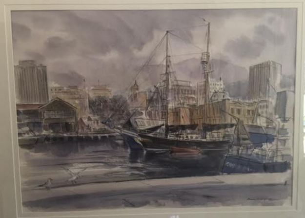
As an example of the artist’s Derwent River related work, a locally owned watercolour (included in this blog with permission from the private owner) titled ‘The Flying Cloud in Victoria Dock’ painted in October 1990, is shown below.  The waters of the Derwent River look fairly glassy in the foreground and a moody Mount Wellington provides a background to Hobart’s port.

Marions mothers max angus watercolour.JPG

Celebrating 200 years of ferries on the Derwent River

The Eastern Shore Sun newspaper for December 2016 provided a community news story which added to the knowledge of the history of ferries plying Derwent River waters.  Turn to Page 11 for the full story and photo.

Two hundred years ago the first licenced ferry travelled from the fledgling township of Hobart across to the eastern shore to a place very close to where I live. The landscape would have been so different; trees would have covered the area where my house now stands.  I wonder if the weather was as warm and pleasant as it has been in the past few weeks around the Greater Hobart area – even exceeding 30 degrees.  Wind is a constant across Tasmania, and the early ferries would have needed skilled personnel to bring their craft safely across the expanse of water and into moorings – especially considering the fact that early vessels were rowed across the river.

Earlier postings on my blog introduced some information about the Derwent ferries, and this latest article supplements what I have offered previously.  While you can search the blog for many posts that mention ferries,  key posts are Ferries on the Derwent River and Historic Granton Tasmania .

Where did the name Tarraleah come from?


According to websites, site 1 and site 2, the name ‘tarraleah’ is the local Lairmairrener Aboriginal word for the Forester Kangaroo.  The Lairmairrener language was spoken by Teen Toomele Menennye (Big River) kinship groups who lived in central Tasmania and further afield.

There is nothing about the township of Tarraleah that has ever made me connect it with our Kangaroo – it has always been firmly imprinted on my mind as a town created only to support the expansion of hydroelectric power.  I wonder how prolific this Kangaroo was in central Tasmania at the time of naming the town; whether the word ‘tarraleah’ was used by white developers loosely without care for accuracy in location.

These days the area of central Tasmania near the Derwent River, where uncleared, often consists of very dense rain forests and I doubt this environment is one easily accessible for the large Forester Kangaroo. Their preference is for more open temperate forests.  Of course 10,000 years ago, the vegetation was different. The last Ice age generally caused much aridity across Australia so I assume the vegetation would have been comparatively open in the area where the township of Tarraleah now stands. Members of our aboriginal communities may possess stories passed down through the millennia about ‘tarraleah’ in this part of Teen Toomele Menennye country.

The National Museum of Australia notes  Bass Strait was not always a strait (of water). It used to be a plain populated by Indigenous peoples who moved back and forth between what we now call Victoria and Tasmania. The first humans arrived in Tasmania around 40,000 years ago. About 30,000 years ago an ice age began, which caused sea levels to drop about 120 metres and created a continuous land mass that stretched between Papua New Guinea and Tasmania. When the ice melted – a process estimated to have taken 6000 years – Bass Strait formed and became an almost impassable barrier by about 12,000 years ago.”

The Australian government explains the Forester Kangaroo, “Macropus giganteus tasmaniensis is recognised as the Tasmanian subspecies of the Eastern Grey Kangaroo, Macropus giganteus, which is widespread throughout the eastern Australian mainland. The subspecies status of the Forester Kangaroo is based on differences in its skull and coat from the mainland population and its isolation in Tasmania for at least the last 10 000 to 15 000 years. Studies indicate that there is less than 1% difference in the mitochondrial DNA between the mainland Eastern Grey Kangaroo and the Forester Kangaroo.”

Tasmania’s Parks and Wildlife Service explains the Forester Kangaroo “is the largest marsupial in Tasmania and the second largest in the world – males can reach over 60 kg and, when literally on tippy toes, stand 2 m tall! Colour varies from light brownish grey to grey. In Tasmania during the 1950s and 60s, the population of Forester kangaroos was reduced to 15% of its previous level.”  Tasmania’s Department of Primary Industries, Parks, Water and Environment  reports “By the early 1900s, as a result of unsustainable levels of hunting (by European settlers in Tasmania) and to a lesser extent land clearance, the species was in serious decline. By 1970, Forester Kangaroos were to be found in only two areas; parts of the Midlands and the far north-east of Tasmania. This was less than 10% of its range at the time of European settlementSince then a number of measures have been implemented to reverse this trend.”

Air quality

You may recall one night I was woken in my tent by the smell of smoke; you can refer to the post with the details.  Apart from that night and the following day as I walked further inland with smoke in my nostrils and not knowing whether I was walking towards or from a fire (I was in an area where access to the internet and mobile telephone reception is non-existent), one of the great delights has been the clean air. Being able to breathe deeply and feel clean on the inside has been a bonus.

From time to time thousands of hectares/acres of our land suffer from unplanned Bush Fires (called Wild Fires in the USA) the source of which may be lightning strikes on dry forests.

In addition various government agencies organise planned burns to reduce the amount of dry vegetation (‘fuel reduction’ being the current term), with the view of preventing major out-of-control Bush Fires when the temperatures increase and the wind blows strongly.  The media always alerts the public so those with respiratory problems can plan to stay indoors or take other precautions.

So at different times, Tasmania no longer has pristine air.  I was amazed when I read this article and found that the air in the Derwent Valley was compared with the extremely unfavourable air quality of industrial India and China.  Back then, the air in that particular locality could be labelled as severe pollution.   Thankfully, the circumstances have reverted to normal … until the next burn.

Rock art vandalised

One morning I read the devastating news that paintings, made by aboriginals before white settlement (Tasmania began to be settled by Europeans in 1803), in a rock shelter near the Derwent River had been vandalised. The images were made by the Big River people, also known as the teen toomele menennye and the cave is considered a sacred site for aboriginal people.

Such caves are unknown among the general public, they are not advertised or signposted, there are no roads to them, and their location cannot be discovered in books.  This shelter is located on private property so that casual walkers are unlikely to have access.

To give some sort of perspective about the number of people who would know about aboriginal sites along the Derwent, inland Tasmania’s country is mostly either under primary production, forest plantations or related to electricity generation. Agricultural properties change hands over time and so it is reasonable to suggest that knowledge of any special sites would be shared across more people than the current owners and property managers.  Caves on Hydro Tasmanian property would be known to a few employees. Nevertheless, outside the aboriginal community, the pool of people who know their whereabouts would be small.  So when I learned of this tragedy I wondered why and who defiled the paintings.

I find it interesting that within a month of Hydro Tasmania releasing a newsletter mentioning the rock shelter, without giving a location, the vandalism was discovered. I wonder if there is a connection between that article and the damage; whether a reader of that newsletter who knew the rock shelter shared information about the site with someone who did not value the cultural history of our indigenous people. If you have more information please talk to Tasmania Police.

Here are some of the media stories:

The Mercury  

The ABC 

The Smithsonian Magazine

Floods and water levels rising


When I walked  along bodies of water dammed on the Derwent River such as Lake King William, I remarked on the low water levels, showed photos of deep barren shores, and posted about the coming danger to Tasmania’s electricity supply.  You can refer to a range of posts for different views on this topic including the following examples: Tarraleah Canal No 1 walk – where is the water?,  Lake King William, The rocky shore, Looking for a place to camp overnight, Death and Lake King William, Rise and shine, Trackless under the powerlines, and Andrew Hughes has walked, rafted and canoed the Derwent over the past month.

Newspapers recorded some of the extremes; here is one of The Mercury examples.

Hydro Tasmania is the organisation which manages water resources  by selling power not only to Tasmanians but via an undersea link to Victorians and further afield on mainland Australia.  For a very long while Tasmania had an unusually low rainfall, then when the Bass Link failed at the end of last year, this meant Tasmania could not buy power from the mainland if in crisis.  Over half a year passed before the fault was repaired and in that time water levels in dams, lakes and the river dropped steadily. In damage control, as politicians and the community worried about the reducing water levels, Hydro Tasmania released the information that our State could survive and continue to generate sufficient electricity in the local newspaper with dams at an even lower capacity . Nevertheless failure for rains to fall, created a situation where massive banks of diesel power generators were installed.  The operation of these generators cost Tasmania millions of dollars. The photo in this article shows an area being prepared for generators, and then the next article shows the installation outside Catagunya Power Station.  Generators were placed in many locations.  This article shows banks of generators outside the Meadowbank Power Station;  this is the closest power station to Hobart and is one of many that operates using the water from the Derwent River.

The dry situation was desperate.  Cloud Seeding was being practised as an option to bring on the rain.

Eventually the gods or nature heeded the call and the heavens opened.  As winter approached, welcome rain poured and began to replenish our dams and lakes.  The rain was heavy and persisted so that the water levels improved dramatically.  In the process, many parts of Tasmania experienced severe floods.  Dramatic stories were released in the media . The Ouse River, which feeds into the Derwent River, was the site of the death of one man.

These were terrible days for many.

Now the climate seems has returned to some sense of balance.  Our glorious spring time, albeit with some hotter days than normal, has passed and summer has arrived.  We all hope for prudent management of electricity generating water resources and for intelligent planning for extreme events – which we know are now more frequent around the world. In this way, the Derwent River will remain a living and useful flow of water which poses little risk to affecting people, animals and the surrounding landscape.

Sailing ships

Yesterday I had the pleasure of sailing around the Derwent River Harbour in a full scale replica of the Lady Nelson sailing ship.  The original was built in 1798 in England and plied the waters between Newcastle and Norfolk Island and Tasmania for the next  twenty five years.  My day on the water was glorious with blue skies, golden sunshine and a firm breeze. When all the sails went up, we scudded along at 7 knots.  Quite wonderful. The image below is of the replica in which I sailed.

Lady nelson from theirwebsite.jpg

The water surface had an almost millpond quality as we returned to the wharf. I couldn’t imagine how sailing ships would cope with heavy seas.

2016-11-18 14.52.17.jpg

I spent a great deal of time thinking about earlier sailing ships and I tried to imagine what it might have been like, with so many ropes and so many sails being part of the picture for months at sea.

The Lady Nelson came out to Australia with around 20 people. The original crew size was 12.

Records show that at times there were perhaps 60 or more people sailing for days on the Lady Nelson.  Yesterday with passengers and crew I suspect our number was around 40. It was standing room only on the deck when all were assembled. Sailing for days would have been very cramped and most uncomfortable by today’s standards (although I recognise that people were generally physically smaller back then than we are today). Add to that, on the original Lady Nelson, the area below deck remained unstructured with one open hold. Apparently people slept on boxes and ropes and all.

My photos below give some idea of the majesty of a sailing ship however small (and it also shows how glorious it is to be out on the Derwent River in Hobart).

2016-11-18 13.34.22.jpg

2016-11-18 14.10.08.jpg

2016-11-18 13.58.40.jpg

2016-11-18 14.14.43.jpg

2016-11-18 14.04.14.jpg

2016-11-18 14.06.14.jpg


The Lady Nelson was approx 53 feet long ,  approx 17 feet wide and weighed 61 tons. I have compared this with the larger ships that arrived in the Derwent River in the early part of the 19th century and so,  after yesterday’s most stimulating sail, I feel I have a small but greater understanding of what travellers (convicts and free settlers) might have been exposed to at sea before they started their comparatively mild run up the Derwent.

The Lady Nelson replica runs trips lasting a few days; I am considering taking one of these small voyages. Part of the deal, if you wish, is to learn to handle the ropes and even climb around the sails.  I wonder if the 19th century crews allowed such liberties to its passengers.

Tarraleah Canal No 1 walk – where is the water?

My walk started well with the Tassie Link bus depositing me on the Lyell Highway at the junction with Butlers Gorge Road, a very isolated spot.  The day was overcast and sufficiently cool to make for extremely comfortable walking.

20160218_101736.jpg

Instead of following Butlers Gorge Road I walked over to Tarraleah Canal number 1 and was stunned.  It contained no running water and green slime was growing at the bottom in sections.

20160218_102406.jpg

20160218_102403.jpg

A question pounded through my brain – where was ‘my’ Derwent River?  I was annoyed.  I was two hours’ drive from Hobart and returning home was not an option. I was here to walk my ‘choice’ of the Derwent River, yet no water flowed.  I humphed and sighed and decided to walk beside the Canal to Clark Dam despite the absence of water, and that would be my story.

Years ago Tasmania decided to sell its clean electricity supplies into the national grid and in tough times to buy in essential electricity supplies.  So an underwater pipe was built beneath Bass Strait, which separates Tasmania from mainland Australia.  In recent months the connection has failed, the Bass Link is yet to be repaired and our state has been unable to acquire additional electricity to meet our needs in the foreseeable future. Meanwhile with low water levels in our Hydro Tasmania dams, our local electricity supplies are in danger of being exhausted.  Therefore, when I saw the empty Tarraleah Canal number 1 I jumped to the conclusion that the water from Lake King William had been turned off; I thought this was a sign of our increasingly dire situation.  Later (and in a later post I will explain) I learned I was wrong.  The empty Canal had nothing to do with the Bass Link failure.

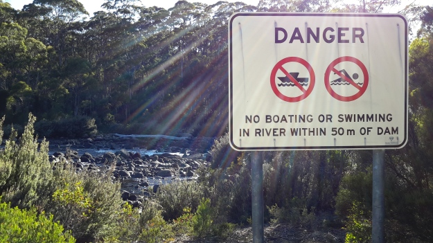
I laughed to see the warning sign.

20160218_101825.jpg

As later posts will indicate, even when empty this Canal is dangerous and should never be entered.

Lake Repulse Dam to Catagunya Dam – posting 8 of 13


When I reached the top of one of many hills, the heat of the day was intense and weariness forced me to stop.  I ate a little lunch. Sipped a little water. Thought about its reducing quantity. Lay down in the shade. And fell asleep.

Increasingly, I was acknowledging my water situation could become serious.

At the start of my walks I carry two one-litre bladders (Think 2kgs of weight).  By the early afternoon I estimated this quantity might not be sufficient: I realised that the hot weather, the energy required to navigate my way around contours and up and down hills, the need to have water to cook with, clean the teeth, and continue on, were likely to deplete my supplies. If I didn’t find water to replenish my resources I could be in trouble.

As it turned out, the first creek with the brown running water was the only source of water that I might have drunk, if pushed.  Later creeks trickled sluggishly and pools sat with green slime and algae.  Obviously no rain had flushed these creeks in ages.

By late afternoon I decided to head inland to a man-made dam of water clearly marked on the map; I was walking away from the River but I needed water and this seemed the only sensible solution.  I walked up and down more serious hills until the dam was in view (can you spot the dam in the first photo?).

20160209_160529.jpg

20160209_172246.jpg

After walking for around seven hours, this nameless dam was a huge disappointment.  The water edges were pudgy with cattle trampings so that the mud oozed up around my walking boots and threatened to suck them off my feet. And the low level of water left in the dam was a thick brown mix. Unreachable and undrinkable.

That night, I didn’t cook because water would have been required. Instead I finished eating my lunch for dinner.  Again at breakfast I ate food which did not require rehydration. At no time did I brush my teeth, although I would have loved to. Keeping water to sip was more important than niceties.

Next morning I walked for two hours to reach the Catagunya complex.  No creeks ran with clean water on the way.  Cliffs and rocky edges made the water of Lake Repulse inaccessible.  I thought that the bridge over the Derwent River at Catagunya might allow me to drop down and brush my teeth, but again – no access. Impossible.

20160210_090929.jpg

Thankfully when I arrived at the Catagunya Power Station, a couple of work cars pulled up.  Inside I was able to refill my water containers and brush my teeth.  Thanks Hydro Tasmania.

I have written before about the challenges of walking and worrying about water. The irony is that the Derwent River is a mighty liquid machine, the water of which can be seen – but mostly it cannot be touched. If a person wasn’t able to keep walking, and didn’t have a Personal Locator Beacon, it would be easy to die of thirst in this remote part of Tasmania in the summer.

Lake Repulse Dam to Catagunya Dam – posting 3 of 13

The major landmark nearest to Lake Repulse Dam is Bilton Hill with its local telecommunications tower.  That didn’t help me much. I had no mobile phone or internet reception for the entire walk.  The area between Lake Repulse Dam and Catagunya Dam is an isolated remote part of Tasmania.

20160209_105315.jpg

I walked on, forever looking down unable not to watch the thousands of cricket insects jumping across the ground and around my legs.  Movements everywhere. Movements may signal a snake so I needed perpetual vigilance.  It was exhausting being alerted by the motions of the constant cricket hops and imagining a dangerous slitherer was the cause of the movement. Only once during the walk did I think I glimpsed six inches of a thick glossy black ‘rope’ disappearing into the undergrowth.  This is not something you check on to be certain.  You just keep going.

Lake Repulse Dam to Catagunya Dam – posting 1 of 13

This walk offered steep hills, challenging fences to navigate, endless webs across my path with an orange striped spider waiting to catch insects (or me), no access to fresh water, and worrying hazy smoke spreading from bushfires elsewhere in Tasmania.

The start of my walk began above the steep forested edges of Lake Repulse Dam (photo below courtesy of Chantale).

IMG_3893Repulse Dam.JPG

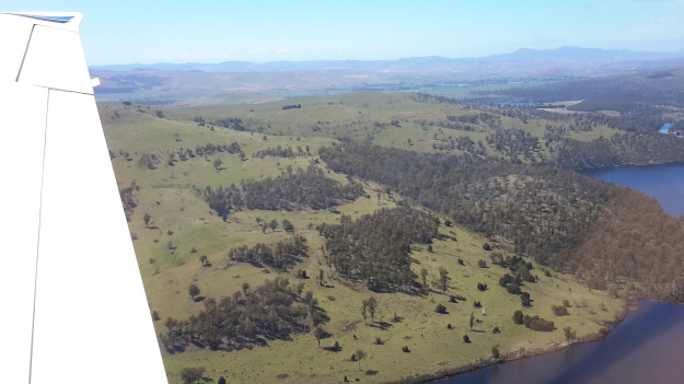
Inland, past the Dam on the eastern/northern side, the landscape is a mix of forest and land cleared for cattle.  The photo below was taken by Michelle. I walked on the right hand side of the water. Note the thick forest along the water edge.  Note the steepness of those banks.

PA280087 Repulse dam.JPG

The photo below, which looks back in a south easterly direction to Lake Repulse Dam, was taken later last year when the grass was green rather than dried and spiky as it was during summer when I walked.

20151028_114913.jpg

The cleared areas are deceptive. They look easy to walk. Despite holding only a grassy coverage, the ground of these cleared areas was irregular and uneven, and it was always inclined up or down – all of which made walking slow.

20151028_114958.jpg

20151028_115002.jpg

PA280088Lake repulse.JPG

My walk crossed cleared lands and passed through forests.  Wherever I went, either I was climbing up or down 200 metres of hillside. Even the lower undulating hills plucked at my leg muscles. For me “hills ain’t no fun”. Eventually I reached the large Catagunya complex of Power Station, Dam and Lake.  Photos below were taken by Michelle and by Chantale respectively.

PA280090Catagunya Dam.JPG

IMG_3889Catagunya dam.JPG

Walking across farmland – posting 1 of 2

From past as yet undescribed walks, I have a large backlog of information and photographs to write into posts and publish. It is my priority to grab snatches of time to write.

Tasmania has been marked by many plus 30 degree days over the past couple of months, and it was on one of those days that I walked next to the flow of the Derwent River across a couple of private farms in the area between Cluny Dam and Gretna. In earlier posts I have declared that my ideal walking temperature is between 15 and 20 degrees and while I dreaded walking in the searing dry heat, I feel compelled to walk when drivers offer their services to get me to the starting point and collect me at the end. Thanks Alex for being available and helping me achieve my goal.

As usual I will not identify the location of my walks between Gretna and Cluny Dam, so that I meet the commitment I make to the landowners to maintain their privacy.  As usual I have a couple of hundred glorious photos and unfortunately I cannot publish most because they will identify the properties on which I walked.  Nevertheless there are some stories to tell and they are not without colour and texture.  Despite the constraints, I will do my best.

On this particular day, the air was bright and clear and the forests beckoned.  When I start a walk, I always wear a smile on my face.

Starting the walk.jpg

The first gate was easily passable.

20160121_113816.jpg

Later I found other gates less accommodating. One makes me smile as I remember, although the gate put me in a spot of difficulty at the time.  I recall the surrounding fences were not climbable and the gate was padlocked. Unfortunately the gate was high (and I have comparatively short legs) and the wire mesh offered no easy toe-hold.  Nevertheless I had no choice but to get over that gate. Somehow I managed to get astride the top, and with the gate moving on its hinges, I sat pressed on the upper iron bar in a most unstable and uncomfortable position.  Because of the movement of the gate I couldn’t get my balance to swing my leg over easily.  No-one around.  No-one expected.  Just me.  On the top of the gate.  Hot sun searing my brains.  I think a cartoonist could have made an amusing image of this circumstance.  Eventually I tried a sort of falling-off-the gate-manoeuvre, caught a strap of my gaiters in the wire mesh and nearly yanked a leg off, and then stepped onto the ground. Relieved. Glad to be on the other side. Obstacles can always be overcome! Of course, the best gates are those that I find open.

Open gate.jpg

Once through the forest, I walked across low level dry vegetation which cracked and crackled as my boots crossed the ground.

Dry vegetation starting out.jpg

Throughout this particular walk the Derwent River always flowed nearby. Once more I fell in love with its colours and movement.  Yet again, I fell in love with the trees and grasses that grow beside the River.

River excerpt.jpg

20160121_121631.jpg

20160121_121939.jpg

20160121_122128.jpg

20160121_123309.jpg


St Clair Lagoon signage

Interpretive signage work needs to be introduced, and current signs rationalised; at least made consistent.  Within metres of each other stood the two signs below:

 20160104_080414.jpg

20160104_080152.jpg

The third sign focuses on the needs of anglers but not on general tourists.

20160104_080445.jpg

One on-site map helps people get their bearings. However, I guess because the water level is generally low, the island close to the St Clair Lagoon Dam which appeared before me as an extensive well-established vegetated outcrop, cannot be seen on the map below.  As a result, visitors may feel disoriented.

20160104_081416.jpg

Four signs exist at St Clair Lagoon. I am disappointed the Derwent River as a whole and the fact this is the River’s source isn’t recognised and celebrated.  The St Clair Lagoon area seems only to anticipate visitation from fishermen who do not have permission to fish here.  A short gravel road detours to the Lagoon Dam from the main gravel road that leads to Pumphouse Point, but no signs have been installed to let people know what they will find if they take the detour, nor the significance of the St Clair Lagoon dam for the Derwent River.
A 215 km river is not a small or insignificant waterway. The Derwent River, as Tasmania’s most iconic river, provides a major marker of thousands of years of social, economic and natural history. In the coming weeks, I plan to communicate with everyone who has influence over the writing and installation of signage and interpretation.