Tag Archives: Bushy Park

The Derwent River in 1958

Recently a friend sent me a link to an extraordinary 9 minute film that was made in 1958. The film is based around New Norfolk, a town located approximately 35 kms west of Hobart. The Derwent River bends around the edges of the rural town that is now built up on both sides of the river.

Enjoy watching the film ‘Valley of the Derwent’, produced by the Tasmanian government, here. Please bear with the excruciating sound of the music so you can listen to the 1950s style narration. The images start at Granton about 18 kilometres west of Hobart. The voice-over explains the original virgin bush ‘had never known the axe or the plough’ indicating a firm belief in the 1950s that taming the wilderness (a euphemism for ‘removing the bush’) was what humans should do. Regrettably there are still too many people (including governments) who feel similarly in 2020.

Early on you see the black swans on the river. David Walsh owner of MONA has just released a diary entry where he refers to the black swan as the unknown unknowns. Makes for interesting reading – here.

I was fascinated that a composer William Wallace, according to the film,  wrote the opera “The Spirit of the Valley” while he stayed at the historic Bush Inn in New Norfolk. It led me on a merry chase through archives and online resources. However recent academic research indicates this is a myth generated over the years, and that even the writing of one song for an opera while he visited New Norfolk is unlikely.

For long term blog followers, the filmed section on the oast houses may bring back to memory my fascination with those at Bushy Park when I ‘discovered’ the texts on the buildings as I walked west from New Norfolk. Refer here.

It made me think how many years have passed and what a world of difference there is since the film was made. For example, I was six years old when the film was produced yet I noted the clothes being worn have the familiar shapes of those of my life through the 1960s.

‘But it’s the river that captivates the eye, twisting and turning along the valley’, so says the narrator. I would say this was true for the entire 213 or so kilometres of the length of the Derwent River.


Big trees

One of the water flows which feeds into the Derwent River is the Styx River.  Long term blog readers will recall, in an early stage of my walk along the Derwent River, I passed the point where the Styx flows into the Derwent in the township of Bushy Park.

20150918_114313.jpg

20150918_114425.jpg

These clear clean waters, and those of the Derwent River are used to irrigate hop fields.

So when media headlines recently mentioned the Styx, I was alert and interested.  The story focuses on an area further inland and in a very remote section of the Styx Valley. You can read more here about the process of photographing one of the world’s tallest trees – and the article includes some sensational photos.

A frisson of excitement pulses through me at the thought of those wonderful primeval forests.  Fresh and clean and original.  But alas, I believe these trees are close to forestry operations where similar trees are routinely clearfelled –  for wood chips! Refer here and here for more thoughts on the matter. If you use Google Maps to look at the Styx River area, a patchwork of logged areas are clearly visible.


Recapping the walk along the Derwent River


I lived the walk along the Derwent with a vital obsession but, after so many months intensely engaged on other projects, now some of the details are vague. To re-immerse myself into the experience, I am writing this post.

In addition, I suspect it will be a great help to people who have become followers of my blog during the past 6 months.  Despite my inactivity, it surprises me how many visitors and views the blog gets daily, how many different posts are read, and how many different countries around the world are represented.

In August 2014, from an impulsive unplanned idea, I took a bus to a spot near the mouth of the Derwent River on the eastern shore, walked to the sea then retraced my steps and began the walk towards the source of this great river approximately 214kms inland.  On day trips, and around other life commitments, I walked in stages along the eastern shore until I reached the Bridgewater Bridge which crosses the Derwent approximately 43 kms upstream.

Instead of continuing inland, I crossed the bridge and headed back on the western shore towards the southernmost  mouth of the River.  Most of the walks along the eastern and western shores between the sea and the Bridgewater Bridge were along designated pathways, although some informal track walking, road walking and beach walking was required during my trips.

Then I returned to the Bridgewater Bridge and began the journey inland expecting only to walk on the side of the river that made passage easiest.  I had no intention to walk both sides from this point onwards in anticipation the landscape would be inaccessible for a number of reasons or particularly wild with dense and difficult forests. I walked to New Norfolk on the western/southern side of the Derwent but from then on, I switched from side to side. Using maps I determined where I must take up each new stage of a walk while switching from side to side, so that I could say I had traipsed the entire length of the Derwent River.

The farthest inland stages of my walk are easily defined.  I walked from near the township of Tarraleah besides Canal 1 (along which is transported Derwent River water) above the actual River bed, past Clark Dam, and around majestic Lake King William to the township of Derwent Bridge.  From there I followed the river to its source at St Clair Lagoon dam.  In case some people believe the source of the Derwent is further inland, I walked onwards to the weir where the Derwent Basin empties into the St Clair Lagoon via passing the southern end of Lake St Clair.

Between New Norfolk and the area near  Tarraleah, my walk beside the River was in country near  townships (some of which were located at a great distance from the River) such as Bushy Park, Gretna, Hamilton, Ouse, and Wayatinah.  This necessitated additional travel to or from the highway and roads, on which these towns exist, to reach the river or to return home from a walk along the river.

Inland, the water of the Derwent River is controlled by dams constructed to create hydro-electricity for Tasmania: I walked past them all. From the end of the river closest to the mouth, these are the Meadowbank, Cluny, Repulse, Catagunya, Wayatinah, Clark and St Clair Lagoon dams.  Each of these has a bank of water behind them:  Meadowbank Lake, Cluny Lagoon, Lake Repulse, Lake Catagunya, Wayatinah Lagoon, Lake King William and St Clair Lagoon.  Most of these dams and bodies of water has a power station: Meadowbank Power Station, Cluny Power Station, Repulse Power Station, Catagunya Power Station, Wayatinah Power Station and Butlers Gorge Power Station.  I was privileged to be shown around one of these power stations during one walk.

Water from the Derwent passes through two other power stations:  Nieterana mini hydro and the Liapootah Power Station.  I did not follow the trail of these Derwent River managed flows.  The water from other locations inland passes through the Lake Echo Power station and Tungatinah Power Station then flows into the Derwent after power generation, thereby increasing the volume of water flowing downstream.  I did not walk along these feeder rivers.

The few stages of the walks which have not been recorded in this blog, are in all the zone between Gretna and the area near Tarraleah – a stretch of perhaps  120 km.  I have written up and posted most of the walks in this zone, and now it’s time to add the missing sections.
Tea from Linden flowers

When I walked from New Norfolk to Bushy Park, I passed a property named Linden.  You can reread my post and the informative additional comments provided by blog followers.

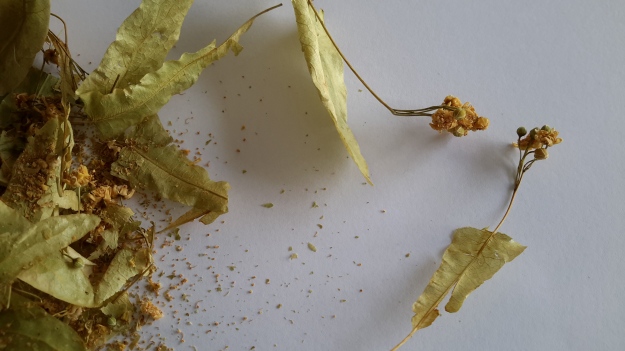
Not long afterwards, a local friend exclaimed with surprise when I informed her that I did not know what a Linden tree looked like, and that I had never drunk tea brewed from Linden tree flowers.  Imagine my pleasure when, one day, Alex called by with a bag of dried linden flowers.  They seemed to possess an ethereal beauty. Out came my camera and here are the resulting photos.

20160516_151652.jpg

20160516_151658.jpg

20160516_151708.jpg

The tea was delicate but refreshing. Most enjoyable. Thanks Alex.

Fields of Dreams

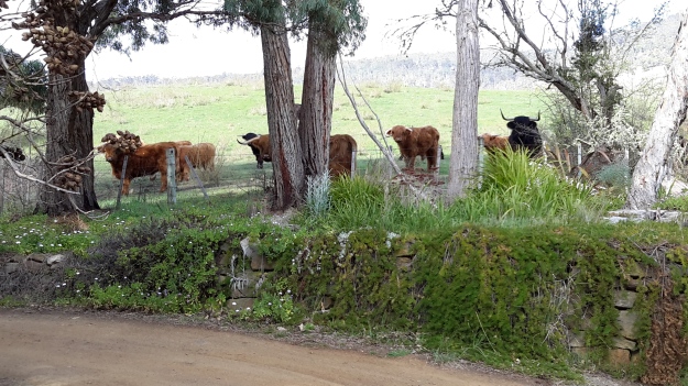
Under the subheading of Horns of Plenty in a local newspaper article, I read about the farmer of the Highland Cattle which I photographed during my walk from New Norfolk to Bushy Park.  By reading the article, I learnt how enterprising Bev Lynd has been, and how useful these cattle are to control the inroads of overwhelming vegetation.  I thought you might be interested in this information.

20150918_090330.jpg 20150918_090340.jpg

My original post can be read at Woolly Long Horned Cattle.

Revisiting sites

With a friend last Thursday and then with another yesterday I returned to Bushy Park,  where I introduced them to the hop kilns/Oasthouse precinct that is hidden at the end of 10 Acre Lane, next to the Derwent River.  They were amazed and delighted with the discovery.

20151031_151004

As it was when I first walked there, no-one else appeared on site. Thanks Alex and Andrew for the revisits. This site proves to be enthralling and special each visit.

Yesterday I realised the vegetation had grown dramatically and lushly in recent weeks so that ‘fences’ of flowering and green leafed Hawthorn blocked some previously easy views.  When Alex and I smelt delicate fragrant perfumes floating in the air, our noses were led to a throng of tiny roses clambering over themselves with a very strong but beautiful perfume. Standing beside this tangle was a flowering tree with perfumed drops of flowers somewhat similar to those on a wisteria, although coloured white.  We couldn’t identify this tree.  In another part of the precinct was a mass of trees with flowers in cone shaped clusters sitting up above their branches. Alex thought they might be chestnut trees.

20151031_150204 20151031_150217

The ducks ran out of the Junior Angling Pool hoping for a feed.

20151031_143852

Idyllic.

Revisiting the hop kilns was my reward after walking a little more of the edge of the Derwent River. But more about that in later posts.

20151031_140708

My sunhat has seen better days but it has a long way to go yet.

Possible locations where the Derwent River can be ‘touched’

I have compiled a list of those locations where I believe, with a vehicle, it will be possible to ‘touch’ the Derwent River occasionally along its length between Gretna and Lake St Clair.  Please let me know if any section listed below takes your fancy and if you would be interested to try it out.

Almost all sections include driving on bitumen highway, gravel roads and poor tracks. Some of these may be forestry roads.  If you wish to volunteer to take me to one of these sections (let me know on walkingthederwent@gmail.com), please feel comfortable that your car can handle the different conditions.  Of course, common sense will prevail and we will never push on if a road is too rough for your vehicle and your peace of mind.

If you are happy to help me reach my goal, albeit differently than originally expected, I would like to fill up your tank with petrol as some compensation.  You know my ‘walking the Derwent’ is a non-commercial project, but since I do not own a car nor drive, I need transport – and therefore, I am happy to cover the cost.

  1. On eastern shore – From New Norfolk drive along the Lyell Highway and then, not far past Gretna’s Sports ground, take a left turn into Clarendon Road and drive to farmstead buildings about 250 metres from the river on a hill. Perhaps 140km return trip.
  2. On western shore – From New Norfolk drive along Glenora Road, and turn left at Bushy Park then right onto Meadowbank Road over the Tyenna River then next to Derwent, then on over Meadowbank Creek to a hill top with buildings. It may be possible to continue quite a way on this road. Minimum 130 and maybe up to 160kms return trip
  3. On eastern shore – From New Norfolk drive along the Lyell Highway and turn left off the Highway onto Meadowbank Dam Road. Continue to dam and southern end of Meadowbank Lake. At least 170 kms for round trip.
  4. On western shore – Travel from New Norfolk and turn left into Gordon River Road at Bushy Park, then turn right off Gordon River Rd into Ellendale Rd and then right onto Rockmount Road before you reach the township of Ellendale. There seem to be many dirt forestry tracks to Meadowbank Lake. At least 170kms return trip and maybe 200kms return or more depending on roads.
  5. On western shore – Travel from New Norfolk and turn left into Gordon River Road at Bushy Park, then turn right off Gordon River Rd into Ellendale Rd and drive on through the township of Ellendale until you reach Dawson Rd / Dunrobin bridge over Meadowbank Lake. Turn left before bridge and it seems we can drive 2kms further up along the Lake edge. Return to Ellendale Road, cross bridge and connect with the Lyell Highway. At least 170kms return trip and maybe 200kms return or more depending on roads.
  6. On eastern shore – From New Norfolk drive up Lyell Highway and continue past the left turn off to Dunrobin bridge and afterwards and to the left there are a number of dirt tracks seemingly without gates. After a while these tracks/roads only extend to the Ouse River and not the Derwent River so map consultation is crucial. At least 180kms return and maybe over 200kms return depending on how many side roads/tracks can be driven along.
  7. On eastern shore – Drive up Lyell Highway past Ouse then turn left at Lake Repulse Road. Continue to intersection with Cluny Lagoon Road and turn left and go to Cluny Dam. Return to intersection and continue on Lake Repulse Road to the Repulse Dam. Can cross a bridge and continue back south around Cluny Lagoon to a ‘settlement’ named Cluny.  Perhaps could access this road from the Ellendale Rd on the western shore? By driving north from Repulse Dam along Dawson Road/then renamed Thunderbolt Road it seems we can take right hand detours to Lake Repulse. Over 200kms maybe 250kms or more minimum round trip.
  8. On eastern shore – Drive up Lyell Highway past Ouse, over the Dee River until the sign appears for a left turn at Catagunya Road. Drive down to Catagunya Dam. 200kms minimum return trip
  9. On eastern shore – Drive up Lyell Highway past Ouse, over the Dee River, past Black Bobs and turn left at Long Spur Road. This runs around Wayatinah Lagoon. Go past the intersection to Wayatinah Dam, turn left and travel to Wayatinah Power Station on Lake Catagunya. Return to intersection and turn left and travel to Wayatinah Dam. Cross bridge and continue on to Wayatinah township. Access dirt tracks in the vicinity of all. Drive south from the Wayatinah Dam on the western shore along the Florentine Road but don’t bother crossing the Florentine River because the road goes inland away from the river. Minimum of 230kms but most likely  at least 300kms round trip.
  10. On eastern shore – Drive up Lyell Highway and when you reach a canal passing under the road, and where the road turns right to go to Tarraleah, go straight ahead on Butlers Gorge Road. Note there are limited roads off and around going closer to the river near that intersection. Continue along Butlers Gorge Road for 10-15 kms heading for Lake King William. Reach Clark Dam and Power Station. Continue onto Switchback Track along side of Lake King William. This track stops and you have to return the same way – swamp separates you from the track north about 500 metres away. This would be a big day and I suggest take overnight accommodation at Tarraleah before setting out. PERHAPS it is possible to walk across the swamp and then walk about 7 kms to Derwent Bridge. Unknown over 300 kms return trip.
  11. On eastern shore – Drive up Lyell Highway to Derwent Bridge and continue past to left hand turn off on the western side of Lake King William and drive the track to the lake. 360 kms return trip minimum.
  12. On eastern shore – Drive up Lyell Highway to Derwent Bridge. Walk from the bridge over the Derwent River near the township of Derwent Bridge to St Clair Dam at the bottom of Lake St Clair Lagoon where the Derwent River starts. Walk to Pump House Point and St Clair Weir at the southern end of the Derwent Basin. 350kms return trip minimum.


Settling in, indoors+

Once inside the Gretna Green Hotel, immediately I felt comfortable.  I walked out to a back room, plonked my gear and then hung onto the bar looking eager.

“Would it be possible to have a shower?  I’m happy to pay.  I don’t care if the shower is in the private residential quarters upstairs.  I’ll even clean it afterwards if that will help.  I’d REALLY like a shower.” All said with pleading eyes.  ‘No. Can’t do,” said the barman.  I stared with desperate eyes, waiting for an explanation.  Apparently TasWater, which manages water quality and delivery around Tasmania, has declared the water at Gretna to be so unsafe that no-one should drink it, and the locals deem it so bad that there is a flow on risk with showering and washing your clothes in it.  “Well we all shower in it, but that’s the risk we take”, barman Brad informed me. “But we won’t let you take the risk.” I spoke up. “If you shower in it then I am happy to shower in it and will even sign a slip of paper saying I am accepting the risk against your advice.”  “No can do. Nah. Sorry.  The publicans won’t allow it,” was the barman’s response. He was trying to be helpful and so I saw no point in putting him offside.  After all, my bus back to Hobart wasn’t passing through Gretna for another 7 hours – I reckoned that creating an aggro situation wouldn’t be smart.

“OK. A bottle of water and a cup of black tea please.”  The cup with its tea bag was soon in front of me.  While the hot drink cooled, I sculled the bottle all the time sitting and chatting to friendly and informative Brad.  After the second bottle and second cup of tea, I began to feel refreshed.  I made up my mind to get clean including brushing my teeth (in the offending water) and to change my clothes, so off I went to the toilets and slowly completed the ablutions and the makeover.  When I left the cubicle, I felt like a new person. I was rehydrated within from having imbibed the fluids earlier, and now I knew I looked different. I felt so much more alive. I only had to survive the waiting time until the bus came through. Only 6 hours to go.

Crossing the Derwent River

In stages over more than the past year, I have walked as near to the Derwent River as I can, and each time I see it up close again I am thrilled. Its scale, its colour, and its texture are always different.  The changing effects of the sky on the water’s surface are fleeting, and I love seeing every view.

On Day two, I had left Bushy Park, crossed the Styx River and was now on my way to the Lyell Highway with a despondent resignation that no more close encounters with the River would be possible this day excepting when I crossed the bridge.

20150918_121005

The bridge was long and offered one lane for traffic and no pedestrian path. This is an area where powerful log trucks, various large transports, farm vehicles, massive four wheel drives, and all manner of smaller cars and motorcycles power along the road.  I considered hitching a ride over the bridge with the intention of travelling across in safety. Thankfully the vehicles do not come in a continuous stream, so I looked for a gap in the traffic.

With an ear to the wind, I listened to hear approaching vehicles. In a moment of quiet I made my ‘run’ for it. Friends would know no running was involved. Rather I stepped out purposefully and as quickly as I could, humping my backpack along with me.

Two thirds of the way across I felt indignant. I wanted to have a look at the river but the fact that it was dangerous to be on the bridge unnerved me. Nevertheless, I glanced around and noticed the magnificence of the views up and down the river. As I readied to take a quick photo I could hear an approaching vehicle.  But I stood my ground.  Then I flattened myself against the bridge railing as a monster dual cab ute whizzed past with the driver glaring at me.  I glared back; I hoped my stony look, backgrounded by thoughts of frustration that walkers were not considered in the bridge design, communicated to him.  I know I know I know. Of course it didn’t. I am sure he simply thought my presence was the impediment to his safe progress.

20150918_121215 20150918_121218

Before long I was off the bridge crossing the Derwent River and heading eastwards to the Lyell Highway.  Getting down to the water was impossible. In this case it was the tangled Blackberry canes that stood in the way.

20150918_121314

A 1904 church

From a distance, the structural framework designed to hold the hop vines ‘caught’ a church like a spider’s web. I walked quickly to find out more about this decorative little building.

20150918_120643

I learned that this very pretty St Augustine’s Church, which sits a short distance from the township of Bushy Park, is part of the Anglican Parish of Hamilton.

20150918_120812

A very large tree effectively blocked opportunities to take full frontal photographs. From the Gretna end of the building, the church appeared as follows:

20150918_120848

I found little background on this church. The foundation stone was laid on the 20th July 1904 by the Right Reverend J.E. Mercer D.D. who was then Bishop of Tasmania.  According to the Tasmanian Anglican,St Augustine’s church is nestled in the picturesque hop fields at Macquarie Plains. This beautiful little church has experienced huge floods over the years, with the 1960 flood almost reaching the guttering, where a small plaque now records the level. It was during such floods that many records were lost or damaged’.

The church is listed on the Tasmanian Heritage Register.

Bushy Park’s Sports Oval

Bushy Park’s sports arena was a typical rural affair; a large expanse of featureless green, a toilet block, a tiny visitor building (‘geez mate it’s starting to rain let’s go and stand under the verandah’), a track, and not much more.  No football goal sticks in sight.

20150918_113424

Barbed wire fences prevented me entering this area and therefore I could not walk to and then walk by the river. I continued along the road, and turned right at the T-junction. A left turn would have taken me away from the Derwent River to Glenora, Mount Field National Park and further afield to Strathgordon and Lake Gordon.  By turning right I was on the way to the day’s destination of Gretna.

20150918_113856

The local hops growing association seems to own the Bushy Park sports oval and offers ‘day use’ only from this entrance point on the road to Gretna.

20150918_114143 20150918_114147

Looking back along the road:

20150918_114000

Looking forward along the road:

20150918_114035

This glorious afternoon was improved by the sensational golden blossoms of this wattle tree:

20150918_113757

Passing a hop field

After leaving the Text Kiln and the other specialist hop buildings in that wonderful grassy green precinct, I continued along a dusty road expecting to connect with Bushy Park’s main road.  Earlier in the day I had read the HPA signs about the need for good farm hygiene so I was surprised no gate existed to stop me walking along this road, and that an unfenced hop field was located directly on my left.

This made it easy for me to take photos of the sprouting hop vines.

20150918_113000 20150918_113007

In the second photo you can see the ropes up which the vine will grow.

Just before I reached the main road, a farm gate was propped open and looked like it had been a long while since it had been closed. The sign on that gate said Private Property.

A splendid hidden world

The shuffling walk down 1 Acre Lane with the wheelie bins was well worth it. The old lady answered my many questions before she continued on to her house when I stopped to admire the first of many extraordinary buildings.

When I look back over this two day walk along the Derwent River, finding an historic precinct at the end of a dusty lane was my greatest joy.  An absolute treasure.  In Europe such a place would attract hundreds of coaches disgorging thousands of people each day to visit. Yet in Bushy Park Tasmania, I was the only visitor. Extraordinary. Some of my blog followers are brilliant photographers and would, if they visited, create amazing pictures.  I hope my photos are sufficient to whet everyone’s appetite for a visit and to have their own experience of this historic site.

The precinct contains an innovative and more recent initiative – a Junior Angling Pond.  Perhaps fishing is the main hobby of locals and what better way to lure new devotees than to offer children their own safe experience.

20150918_110949 20150918_110931

The buildings had no or limited signage, therefore identifying the purpose of most was impossible for me.

20150918_110540 20150918_111534

20150918_111352 20150918_111015

The photo below looks like a large unusual house but apparently this was the bakery feeding the hundreds of workers involved with the hop industry in the past.

20150918_110919 20150918_111059

The most surprising structure was, what is now known as, the Text Kiln, built in 1867. As I approached the building I did not know this name or the year. Immediately I loved the shapes of the structures then suddenly I was stunned see a sandstone plaque embedded high up on a wooden wall. This was a biblical text.  And nearby was a second text. My mouth dropped open; I wrinkled my forehead and shook my head.  What am I seeing? What is going on here? In this remote location, clearly the early hop growers placed a great deal of importance on the Christian scriptures. I wondered if this text indicated a puritanical god-fearing way of living in the 19th century in Bushy Park. What was that community like?

20150918_111152 20150918_111201

20150918_111250  20150918_111239

Beneath a window one text offers: ‘God so loved the world that he gave his only begotten son that whosoever believeth in him should not perish but have everlasting life’.  In a triangular alley another plaque exhorts us to ‘Have faith in God’.

As I walked around the building, I saw many more texts .

20150918_111239 20150918_111338 20150918_111400 20150918_111441 20150918_111521 20150918_111605

In all, approximately 13 different texts exist on three sides of this magnificent building.

20150918_111648 20150918_111752

Eventually I left the Text Kiln and wandered further around the precinct.

20150918_111923

The old lady, owner of the wheelie rubbish bins, lived on-site in the red-roofed house.

20150918_112259

I guess the red bricks have been painted over in the building named the Red Brick Kiln, shown in the photos below.

20150918_112237 20150918_112041 20150918_112024

The last building I looked at before following another dirt road to the main road, was the Picil Kiln as pictured below.

20150918_112213 20150918_112449 20150918_112410 20150918_112621

I hope to bring friends here with a picnic hamper and perhaps a bottle of bubbly in order to relax and soak in the quietness, and to be pleasantly stunned by the scale and dramatic shapes of the buildings.  Perhaps I will see you there one day.

Hop farms

Suddenly, I was on the outskirts of the tiny town of Bushy Park and hop fields began to edge the road.  In case you don’t know, hops are the raw material for beer so the agricultural activity in this area is serious business. In Tasmania we have two mainstream brewers; the Cascade and Boags breweries plus other interesting boutique beer makers.

20150918_104145 20150918_104214

The Beer Pilgrim  has lots of photographic information to offer. An ABC news item includes photos of the hops and some processes. In addition, information about the growing patterns of hops, their harvests and other details are located at Hop Products Australia abbreviated to HPA.   I was fascinated when I read ‘The hop plant originated in China, but it was the Germans – way back in the 11th century – who first discovered the crop’s potential as an ingredient for beer, and they’ve been at it ever since.’ I wondered whether the world would be a different place if the Chinese had made that discovery first.  What would be the Chinese equivalent of an Oktoberfest?

20150918_104512

When I read the sign in the photo above, I felt good that I hadn’t found a way to walk on the river edge on the other side of these hop fields – if I had, then the soles of my shoes might have delivered exotic seeds or destructive pests to the ground.

As I continued walking, I enjoyed looking at properties and different vintages of houses.

20150918_104908 20150918_104945

20150918_105413 20150918_105504

20150918_105631 20150918_105841

20150918_105603

The hop vines were not yet growing up the lines so the views across the paddocks were relatively uninterrupted. Before long, across a hop field I could see specialised hop buildings near private houses.

20150918_105817

Then, as I reached 1 Acre Lane, at the far end I could see Oast Houses and other large buildings.  In the Google Map photo below the hops have grown up the vines on the left and they obliterate the views I had over the empty paddocks – but this is the lane if you are visiting Bushy Park and looking for what I could see. On the street view of Google maps no sign naming the lane is in evidence, but since that street view was made a sign has been attached to a pole on the non-lane side of the road.

Bushy Park lane to oast houses

My feet were aching and touchy at each step. I wondered whether I had it in me to walk down the lane to see whether there was public access and have a look around, and then have the feet to walk back to the road.  I still had quite a few kilometres to go to reach my day’s destination at Gretna and I felt rationing my steps could be a good idea.

Just then an old woman, on the main road, was dragging two large empty rubbish wheelie bins towards me and the lane.  A tiny lady, I felt she could have fitted inside one of these.  It looked like a massive effort for her. She was pleased to rest and chat with me. I asked if public access was available and she told me that I could look around the buildings but not in them, and that most were heritage buildings and no longer operational. She headed off down that very lane. That long lane.  After she had taken a few steps she stopped for a rest. I realised this was a weekly challenge for her after the rubbish had been collected. I had no idea how far she had to walk with the bins, and since I could not see any residential houses I guessed that somewhere at the end of the lane in the precinct with the Oast Houses and other specialist hop buildings, she had a house. I called out ‘Can I give you a hand and take one of them?’  She didn’t have the energy to look grateful and simply said, ‘Yes’.

With apologies to The Beatles – The long and straightened road / That leads to her door / Will never disappear / I have not seen the road before / It will always lead me there / Lead me to her door

Unpredictable water levels

20150918_102136

This sign is located near Rayners Corner beside Glenora Road on route to Bushy Park.

Years ago a friend and I drove up along the Lyell Highway, and then took a track down to the river somewhere between New Norfolk and Gretna.

We walked across a gravel bed to a rocky scrubby clump edging the water.  For a couple of hours we sat on the river side with our feet swinging above the glossy glassy black racing water of the Derwent River, lulled by the sun. I remember the clear reflections of the dense vegetation on the other side of the river. It was a joy to see fish rising to grab an insect that had been flitting near the water surface. Clouds began to pile up in the distance and around that time I looked down and realised the water was nearly touching my feet. The river’s water level was rising. We clambered back to the other side of this outcrop and discovered, to our horror, a swirling and dramatic pour of water separated us from the river bank. In recent blog postings I have mentioned the speed with which the Derwent River travels towards the sea. That day was my first experience of its dangerous fast moving flows.

The river was rising as we watched. We were stranded on an island and we didn’t know how much water had been released upstream. This meant we didn’t know whether the island would become submerged. Within seconds we knew we had to try our luck and get back to land.

Quickly we cast our eyes around for a couple of suitable branches that could act as walking sticks, as balancing poles, so we could cross the raging torrent.  Each of us started the crossing with a balancing stick. I remember stepping into that cold water and finding how uneven the ground was. It was not a simple gravel bed rather I was trying to walk on irregular sized rocks that rolled when I was pushed onto them by the force of the water. I remember that it was important to tread slowly and to lean my body at an angle towards upstream to counteract the pressure to send me downstream.

When I started the crossing the water level was at the top of my thighs. The distance wasn’t far but the water reached around my waist and splashed higher as I approached the safety of the river bank.  Once out of the water, we felt exhilarated.  But we both knew the danger we had been in.  And similar signs to the one in the photograph above were not around.  Situations like this remind me of the powerful importance of local knowledge.