Author Archives: Tasmanian traveller

Unknown's avatar

About Tasmanian traveller

Through travel, I have experienced the eccentricities of people and their environments around the world. At the same time, I love where I live. So, for people who cannot travel to discover the wonders of my home town, this blog is an attempt to introduce its exoticness. My goal was to walk along both sides of Hobart's Derwent River from the mouth to New Norfolk, and to walk on one or alternating sides of the River between New Norfolk and the source of the River at the southern end of Lake St Clair. The walk was undertaken in stages around my other commitments of my life. Almost all stages of the walk connected with Tasmanian public transport - my intentions was to inspire people, who do not have access to a vehicle, to feel they can replicate the walks. This blog reports on each stage in the hope it will encourage people to either follow in my steps or to create their own walking project where-ever they live. Please note: The blog background and headliner image of 'Hobart from Mt Wellington' is the work of Tourism Tasmania and Garry Moore. It is a free image with unrestricted copyright and available from http://www.tassietrade.com.au/visual_library

Meeta Pandit at the Theatre Royal in Hobart

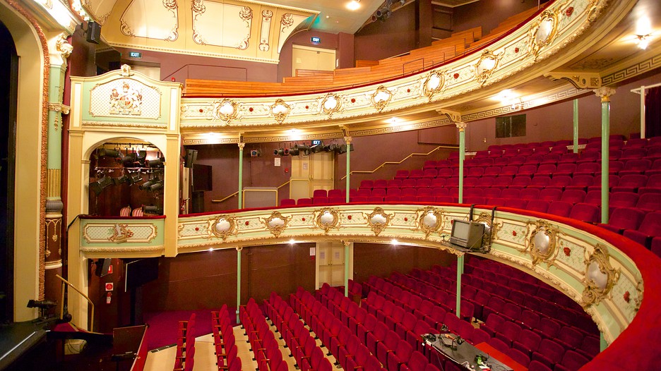
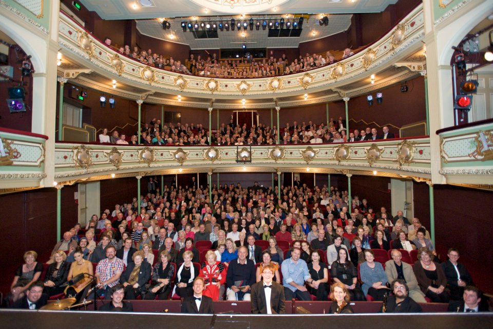
Having established the Theatre Royal’s connection to the Derwent River, it is now an easy step to exclaim about a recent performance staged in that theatre.

Before booking seats for an Indian classical music concert, I conducted no research so I was surprised by the extraordinary powerful and musical voice which flowed effortlessly from the stage one night this week.  At the concert I discovered that Meeta Pandit, internationally renowned vocalist in the Hindustani tradition, has established herself as a highly revered singer of classical Indian ragas.

Wikipedia informs me that ‘The term “Hindustan” has been historically applied to the Gangetic Plain of North India… Hindustani classical music is the … North Indian style of Indian classical music.’ I also learned that ‘It is traditional for performers who have reached a distinguished level of achievement to be awarded titles of respect; Hindus are usually referred to as pandit and Muslims as ustad.’

Meeta Pandit’s performance was amazing. Vocal gymnastics of the most wonderful kind.  Her perfect pitch, extraordinary breath control, and the rapid precise movement up and down the octaves kept me spellbound. In addition, the hypnotic wandering of her fingers drew me in more deeply.

Later, when I listened to samples of her singing on http://meetapandit.com/, it sounded very nasal, common and unspecial and that’s not what I heard.  At the concert it was pure sound.  Pure.  Music.  I travelled to India many years ago and since then have listened to music from India in many forms.  Because of Meeta Pandit’s superb vocal quality and performance abilities, I now feel the Indian music I experienced previously only amounts to wailing and unpleasant piercing assaults on my ears by comparison.

My accompanying friend, a follower of this blog, exclaimed ‘who would have thought when the Theatre Royal was built almost two centuries ago that one day someone with a voice as fluid and melodic would travel from a country with even greater rivers than the Derwent, to grace the stage and leave an audience gasping for breath and overwhelmed by such brilliance.’ Meeta Pandit comes from the northern part of India which is slightly west of centre where great rivers such as the Yamuna River flow and, during this week’s concert, she mentioned rivers in her songs. At the risk of alienating readers with words that seem cheesy, it seemed to me the sounds from her vocal chords flowed like the continuous silky smooth waters of inland rivers. It was that good! Okay. Enough of my use of superlatives.

At the Theatre Royal concert, a fellow musician played hand drums and another played a Shruti box with bellows that provide a drone accompaniment, but I saw no string instruments. You can watch You Tube videos on many sites and gain an idea of Meeta Pandit’s vocal ability and musicality; examples include –

 https://www.youtube.com/watch?v=-w4Fji9E8Ww

 https://www.youtube.com/watch?v=-JEk9eZiVUI

Theatre Royal, Hobart – proximity to the Derwent River

The Theatre Royal located on Campbell St Hobart was built in 1834 and is the earliest theatre built in Australia that is still fully operational today – each week the Theatre Royal stages various events: theatre, dance, musicals, opera, eisteddfods, music concerts or comedy. After a disastrous fire in 1984, the building was restored to its former glory and its delightful small but grand interior is now well worth a visit.  Guided tours are on offer during the day.

Theatre-Royal-67902

But what does the Theatre Royal have to do with the Derwent River you may wonder.

Firstly, it is located only a stone’s throw from the Hobart Rivulet that flows into the Derwent River. The Hobart Rivulet was the source of fresh water to the first settlers in Sullivans Cove (a bay in the Derwent River) in the years after they established the colony in 1804. Picking up the crystal clear waters from flows on Mount Wellington, the Hobart Rivulet wound its way through the early ‘Hobarton’ and these days it continues to flow under much of the current city of Hobart.

Secondly, the early shores of the Derwent River were further inland in the early 19th century than today. Considerable land fill has been added over the past two centuries.  When the Theatre Royal was built, the Derwent River was a little closer than today.

I have entertained myself with searches for old maps of Hobart so that I could understand where the Theatre Royal was located in relation to the original foreshore.

The image of the foreshore at Sullivans Cove below was drawn in 1804 (this was the year of first settlement here). Hunter Island was on its own before it was connected to the mainland by a causeway. This island was located not far from where Campbell St (the street on which the Theatre Royal is built) was established much later. The drawing shows the extensive forests which were removed over subsequent years to make way for the streets, houses and public buildings (image from http://www.tasfamily.net.au/~schafferi/images/Ocean&LNHunterIs1804img141.jpg

Ocean&LNHunterIs1804img141  Hunter island 1804

The site http://www.tasfamily.net.au/~schafferi/index.php?file=kop15.php offers the opinion ‘It is hard to imagine what Hobart Town would have been like when Lt. Gov. Collins arrived in 1804.  The rivulet ran free, (except when it rained heavily sending logs that blocked the rivulet, sending water spilling across its banks) large gum trees stood on both sides of the rivulet, some of which had to be cut down to make room for the new settlement.‘  The drawing below, made by George P Harris in 1805 or 1806, seems to look across Hobarton from what today is referred to as the Domain.  I think Harris employed a great deal of creativity when making the picture because the Mount Nelson Signal Station looms large on the distant hill yet it could not realistically have been that height.  

HobartTown1821closeup2-tasfamily.net.auschafferi

Below, the 1811 town layout has an overlay of our contemporary streetscape (from http://www.abc.net.au/news/2015-02-24/footsteps-towards-freedom-art-project-begins/6251596).  If you can locate the intersection of Campbell St and Collins St, then you can appreciated that the yet to be built Theatre Royal will be sited a few metres along Campbell St (on the block at the top side of the letter E of Street). You can appreciate how close this is to the Rivulet and to the Derwent River.

1811 -abc

George Evans lithograph of 1819 below shows how little progress had been made in terms of new buildings and street construction 15 years after settlement ( http://www.abc.net.au/news/2014-08-22/1819-slnsw-south-west-view-of-hobart-town-1819-george-william-e/5689410)

George Evans South west view of Hobart town

By 1832 significant developments had been made to Hobarton .  The map below (from http://www.auspostalhistory.com/articles/180.php) was made two years before the Theatre Royal was built.  Can you locate Campbell St?  Once found, can you see the thick black line that crosses it – that line is the Hobart Rivulet? The future location for the new theatre was a couple of house blocks away from the intersection between the street and the rivulet.  Looking at the shoreline with the Derwent River, already it is clear land has been reclaimed along the edge; the shape is manmade and the landscape no longer flows naturally.

180_TN.IMAGE3 1832 hobart

On the Proeschel map below (with the hand writing at the top of the map indicating 1858), locate the intersection of Collins and Campbell Streets.  Nearby, the Theatre Royal is listed as Public Edifice number 23 (from http://catalogue.statelibrary.tas.gov.au/item/?id=879658)

Map_and_select_directory_of_Hobart_Town

In Jarman’s map of Hobart Town (http://catalogue.statelibrary.tas.gov.au/item/?id=573294 indicates the date for this is 1858, although if the Proeschel map’s date is correct then the differences are too marked for this to be correct. More research required.), the end of Collins St has been modified so that two streets are located one either side of the Rivulet (black rectangle above Collins St is the Theatre Royal).

Hobart Town

A woodcut map of 1879 by A C Cooke (from http://catalogue.statelibrary.tas.gov.au/item/?id=94421) gives a bird’s eye view of Hobart Town. On the lower right, the large watery dock can be seen intruding into the townscape. At the top end of this water is the large City Hall with Campbell St on its right hand side. Immediately behind the City Hall is Collins St.  Therefore the Theatre Royal is located on the right hand side of Campbell St a little above Collins St.

_Hobart_Town____A_C__Cooke__delt

The area around the Hobart Rivulet routinely flooded the streets after heavy rains in the 19th and early 20th centuries (substantial new drainage systems now prevents such occurrences). The photo below (from http://www.linc.tas.gov.au/tasmaniasheritage/browse/exhibitions/hobartrivulet/diversions-and-floods/image-3) was taken after a flood in the 1920s. We are looking back towards the centre of Hobart Town along the Hobart Rivulet. The large curved roof at the right of the photograph is the top of the Theatre Royal and, therefore, the first bridge in the distance which crosses over the Rivulet will distinguish Campbell Street.

Floods-NS869-1-497 1920s rivulet end of Collins

The photo below (http://www.linc.tas.gov.au/tasmaniasheritage/browse/exhibitions/hobartrivulet/diversions-and-floods/image-2) was taken during flooding in the 1930s.  The building on the right hand side is the City Hall which still functions as such today.  The road to the right of the flooding Rivulet is Collins St and people are standing on Campbell St above the Rivulet.  Therefore, the Theatre Royal is just out of shot to the left from where people are standing watching the torrent.

flood1 1930s flooding rivulet near theatre royal

Leo Schofield’s short-lived but internationally renowned Hobart Baroque festival lit up the Theatre Royal with spectacular performances.

Theatre-Royal-Hobart  seated people

Our Theatre Royal was located for easy public access 180 odd years ago, and the site continues to attract crowds easily. A new performing arts centre will be built next door over the next couple of years.  The Tasmanian Art School is located close by in Hunter St adjacent to the wharves and jetties jutting into the Derwent River. It fits with history to develop an artistic precinct near the water.

Reliving GASP and MONA with a new walk along the Derwent River

On Stages 9 and 10 of my walk along the Derwent River, I passed the Museum of Old and New Art (MONA) and the Glenorchy Arts and Sculpture Park (GASP).  Yesterday I had the opportunity to introduce two international visitors to these important arts structures.

Mid-morning I met with a follower of my blog, De from upstate New York and her Arizona cousin Ke as we were chauffeured thanks to Ma, from the centre of Hobart to our starting point near the Derwent Entertainment Centre.

Our excursion started from the Pavilion at the southern end of the Glenorchy Arts and Sculpture Park (GASP) near the Derwent Entertainment Centre.  Do you remember my photos of that surprise pink glass wall?

20150109_085808

From a distance and approaching this structure, it looks dull, industrial and disused. But just as I had felt during my walk, my two new international co-walkers were amazed once we arrived at the site. Quite delightful and I have no doubt De will be displaying her own photos on https://deescribesblog.wordpress.com/ when she has time.

Then we started strolling and rolling along the bike/pedestrian path towards the slatted walkways with their colourful striped edges.  Many photos were clicked every time we reached a new striped walkway with a different set of colours.

20150319_111418

De gets around in a motorised wheelchair so when she spotted a scooter with its dinghy trailer (see photo below) waiting for its owner to return from their boat out on the Derwent River, she stopped in amazement. We talked about how good security seemed to be locally.  The scooter owner had left his/her shoes, helmet and other personal items, and despite a security strap set up to prevent movement, we all knew that enterprising thieves seem to carry bolt cutters with them these days.  But all was well yesterday.

scooter

Gradually clouds disappeared, the mountain looked sharp and much of the sky was blue.

20150319_114408

Glorious.  After a very cold North American winter, De soaked up the sunshine as the day warmed and we did everything to stay outdoors that we could.

We continued along the foreshore and turned towards the highway when we reached the Montrose High School. Then we were onto the bike/pedestrian track past Rosetta and into Berriedale before advancing up the entrance incline to the Museum of Old and New Art (MONA).  Along the way we admired the new autumnal colours of the Moorilla grape vines beside the road.

Vineyards

A visit to the exhibitions at MONA requires descent into cavernous spaces below ground so we decided to enjoy a lunch break first.  Despite the busyiness of the café directly above the museum, De motored through gaps in the visitors and took us outside into the open air where tables and chairs are set on the lawn. We admired great views up, down and across the Derwent River.

Our sparkling Moorilla wines were crisp and delicious, and the food choices were expansive.  De and I settled on a soba noodle with spring peas and pickled ginger salad, and Ke tucked into an Italian summer salad which included a great variety of ingredients dressed with the best local olive oil. Ducks and peacocks were out and about, seemingly comfortable with the thousands of visitors that come to MONA each week.

Satisfied by lunch we returned inside and took the lift to the bottom floor of MONA. Over the next couple of hours we wandered through the three levels of exhibits before De and Ke found the upstairs bookshop. The wonderful conclusion to our visit came when De spotted a spectacle outside.  They left the building and, along with a throng of tourists, took photographs of a huge unblemished and bright rainbow crossing over the entire River.

It was a great pleasure to show non-Tasmanians a small part of where I have been along the Derwent River, and De and Ke’s enjoyment enhanced mine. Thanks for your company and best wishes De for your conference presentation in Burnie tomorrow encouraging people to understand there are few limits other than those we set ourselves.

Denise leaving MONA

Both De and Ke gave me permission to include their photos in this blog.

Historic Granton, Tasmania

The northern suburb of Granton on the western shore of the Derwent River adjacent to and extending from the Bridgewater Bridge has significant history in relation to transport and communications across Van Diemens Land/Tasmania. Two heritage buildings, which still stand, are introduced below.

The Black Snake Inn

On stage 8 of my walk along the Derwent River, after I had crossed the Bridgewater Bridge from the eastern shore, I continued south into the start of the suburb of Granton. On that route I soon passed the house in the photo below.

20141111_134404

Located at 650 Main Road, what I was seeing was the building that started life as the Black Snake Inn, apparently Australia’s earliest ferry inn, which was built by the convicts who constructed the Bridgewater Causeway. The Google maps street view of this remarkable building can be seen at https://www.google.com.au/maps/place/650+Main+Rd,+Granton+TAS+7030/@-42.751047,147.229129,3a,52.5y,209h,90t/data=!3m4!1e1!3m2!1sTcT1xn5QTiR_rSA4AsFFbg!2e0!4m7!1m4!3m3!1s0xaa6e12713b1bfcbb:0x1a0841b5479abad1!2s650+Main+Rd,+Granton+TAS+7030!3b1!3m1!1s0xaa6e12713b1bfcbb:0x1a0841b5479abad1!6m1!1e1?hl=en

According to http://www.werelate.org/wiki/Person:George_Robinson_%2838%29, Rhode Island born George Robinson erected a new Black Snake Inn on an earlier ferry Inn in 1833 and continued his business at the Black Snake until 1837.  Robinson showed his enterprising ability in a newspaper notice: “MR. G. W. Robinson has this day started a Van with two splendid horses for the immediate accommodation of persons travelling up and down from the Ferries. The Van will leave the Black Snake at half past nine every morning, and leave Hobart Town at 2 o’clock every afternoon…

Charles F Tomkins

Artist Charles F Tomkins (1798-1844) produced a hand coloured lithograph titled The Black Snake Inn and this was published in London by Smith & Elder in 1833 (Reference: http://catalogue.statelibrary.tas.gov.au/item/?id=98999)

According to the http://www.heritage.gov.au/cgi-bin/ahpi/record.pl?RNE10944 record (of March 2015), The Black Snake Inn ‘is significant for its association with Derwent River ferry and road crossings. Until 1836, when the Bridgewater Causeway was completed and before a bridge completed the crossing in 1849, ferry transport was the only means of crossing the Derwent River. It is significant for its initial function as a ferry inn accommodating passengers using the commercial ferry services run by the Inn’s operator. In addition, the Inn is significant for providing accommodation for travellers on the Main Road between Hobart Town and New Norfolk, and those using the Bridgewater Causeway. Between 1819 and 1825 the diary of Reverend “Bobby” Knopwood noted frequent visits to the Black Snake Inn which was often referred to as the “half way” house. Governor Arthur’s Land Commissioners visited the Black Snake Inn in 1826, remarking that its licensee, Presnell, was in the “true Style of a selfish Settler” giving all who passed “all the trouble in his power”. By 1833, the Inn was acquired by George Robinson. By August he had built a “new house’ at Black Snake and advertised the lease for the old inn premises as a possible store. His new Inn was drawn by Louisa Meredith, probably in the mid-1840s and the structure depicted is almost certainly the building known as the Black Snake Inn today, showing the same form. It is possible that a new facade was erected some decades later because the Victorian Rustic Gothic style became more common after the 1840s.’ This website provides extensive additional historical, architectural and social information.

The site http://www.watersideaccommodation.com/downloads/HistoricalSummarytheClaremontAustinsFerryArea04May07.pdf contains an alternative photograph of the building.

I am grateful to Tasmanian collector and historian George Burrows for his reminder to create a posting about the Black Snake Inn.  In addition, he told me… “I am probably one of the few people who have canoed the river from source to Hobart BEFORE the dams were built.”  How remarkable is that!  Very impressive.

The Old Granton Watchhouse

The building, located at the junction of the Brooker Highway, Lyell Highway and the Bridgewater Causeway, was built by convicts in 1838. Extensive information and photographs can be seen at http://ontheconvicttrail.blogspot.com.au/2014/10/old-watch-house-granton.html

The starting point for Stage 14 of my walk along the Derwent River will be near this Watchhouse.

Kunanyi

Mount Wellington was a prominent feature in the lives of the Moomairremener people for thousands of years before white settlement of Van Diemens Land, later to be renamed Tasmania.  The indigenous names include Kunanyi, Unghbanyahletta and Poorawetter. I understand that the Palawa (which seems to be a collective term for all Tasmanian aborigines – perhaps a blog reader might be able to supply further information?) who are the surviving descendants of the original indigenous Tasmanians, tend to prefer the former name – Kunanyi.

A couple of years ago, the Tasmanian government introduced a dual naming approach to a number of geographical features around Tasmania, and these included the mountain which towers over the Greater Hobart Area and the Derwent River. The then Premier Lara Giddings remarked ‘Dual naming is about recognising the Aboriginal community’s rightful status as the first inhabitants of this land and celebrating their living culture, traditions and language’.

20140926_123103

Photo taken from Bellerive Bluff on Stage 4 of my walk along the Derwent River.

20141010_103145

Photo taken between Rose Bay and Lindisfarne on Stage 5 of my walk.

20141031_132509

Photo taken from Old Beach on Stage 7 of my walk.

20141111_104035

Photo taken from Green Point on Stage 8 of my walk.

I am including a posting specifically about ‘the mountain’ as locals refer to it, because it has been a significant marker on my trek from the mouth to the mouth of the Derwent River via the Bridgewater Bridge, and I am about to lose sight of it.  From Granton, as I walk west along the River and then northwards, the mountain will no longer be in view.

Current official information about walking tracks, facilities, weather related precautions and other details associated with the mountain can be read at http://www.wellingtonpark.org.au/  Note that you can download maps from this site.

International traveller may join me for a walk

A few months ago I was excited when a blog follower from upstate New York, told me she was coming to Tasmania and would love to take a walk with me to see some of the sites I have shown in my postings.  With increasing anticipation we have corresponded and now I expect her arrival this week. Sometime around midweek we expect to undertake a comparatively short ‘stroll’ from the southern end of the Glenorchy Arts and Sculpture Park (GASP) over the wonderful striped edged walkways over the edge of the Derwent River.   Do you remember them? For example,

20150109_083005

and

20150109_084404

Then we will head northwards into Berridale and on to MONA (Museum of Old and New Art) with all its fascinations.  Perhaps we won’t be able to get away but if we do, there is always the possibility we might continue on to Cadburys chocolate factory. This doesn’t seem too shabby an itinerary.  What do you think?

Of course we will exercise our right to choose somewhere else to walk if we wish.

If anyone else is visiting and wants to relive a section of the edge of the Derwent River over which I have passed, please email me on walkingthederwent@gmail.com.

My first walking story video

Thanks to Lara Van Raay, Producer with ABC Open for southern Tasmania, I completed a 3 hour workshop devoted to editing a series of brief video shots that I collected during the week. When long-term blog followers look at my final video story, they may recognise the location. I covered this area in stage 5 of my walk along the Derwent River, when I walked from Rosny Point to Geilston Bay.

This video can be seen at https://vimeo.com/122073284 or

https://open.abc.net.au/explore/14ov5vx

I used VideoPad by NCH Software (http://www.nchsoftware.com/videopad/) for sequencing and editing the video clips. This is freely downloadable. I found it easy to use initially and even easier after taking time to watch some of the excellent and simple online tutorials.

Once the video was complete I uploaded it onto Vimeo (which, unlike You Tube, isn’t a site with advertisements). From Vimeo, I have added the video story to ABC Open’s projects ‘where you will find me’ category (refer https://open.abc.net.au/explore/14ov5vx).  If you are Australian and write stories or make video stories, you can find a place to upload them onto the ABC Open site; it is one way of sharing experiences around our country.

This is my first attempt at story creation in video and I recognise both my filming and editing are very rough around the edges.  Nevertheless, everyone has to start somewhere. During the coming winter months when I cannot continue my walking in the centre of Tasmania because of miserable weather conditions, I may use the opportunity to work on story lines with locations closer to home.

Happy viewing!

I pay my own way as I walk along the Derwent River

stockfreeimage.com Aust money notes rolled

Some friends feel sure I must be asking for freebies, discounts, backhanders, cash-in-hand or other special deals from businesses, restaurants, accommodation facilities, buses and other organisations which I comment on in my blog, as I pass along the Derwent River.  No, I do not. I have not asked for, I do not seek for, and I do not expect to receive service or goods for free or cheaper simply because I have something to say about them in my blog.

I would not like to feel fettered by an obligation to ‘go easy’ on a business or product which was substandard.  I would not like to feel pressured to remark on a particular product or service that I was not interested in, or I could not make relevant to the walk along the Derwent.

In the current environment when travel writers routinely have their costs covered and often have access to premium products and services for no charge, I can understand why some people might be surprised to learn I have not joined that gravy train. That way of funding travel is not necessary for me; to date, my only cost has been small local bus fares.  I would like to be able to make any comment I prefer about Hobart’s Metro bus service and, therefore, I have not approached them for assistance.

Of course, the future is a different place and when I venture northwards, no longer will I be able to organise walks as one day events.

I will need places to stay overnight occasionally. In addition, I will be using different public bus services so my costs may be greater than those which I am used to. Despite the likelihood of increased costs, I view these walks as my ‘holidays’ and I am prepared to pay for them.

When I started the blog, one of my intentions was to inspire local people to follow in some or all of my footsteps. I want local readers to know exactly what the situation is and so my walks will not be doctored by special privilege.

???????????????????????????????????????

Another matter concerns me.  I hear rumours that a few tourism operators away from the main cities and towns are not always serving their customers in the hospitable contemporary way many of us feel visitors to Tasmania should expect.  If I find some ‘bad eggs’ in the more remote parts of Tasmania, then I want to be able to expose their weaknesses or recommend possible improvements in my blog (and probably on Trip Advisor as well).

??????????????????????????????????????????????????????????????????????????????????????????????????????????????????????????????????

(Photo above ‘Fresh Start” from Dreamstime.com)

On the other hand, where I find excellent service, I want to reward that with the words and pictures of my choosing. On this basis, I see no reason to persuade people to give me a free night’s accommodation or meal or pay for any other expense which I might incur.

Hmmmm.  Almost seems a shame to take this point of view!  I wonder if blogger jenspen1961 from Cairns, when she sets off walking around Australia, will think differently.

Freeimage sockfreeimage.com of map of money australia

Pumphouses

Tasmania’s productivity was given a boost from the 1930s onwards with the building of hydro-electricity generating schemes to support the development of manufacturing and other industries.  From this activity a number of decommissioned pumphouses now exist across Tasmania.

Recently, when I revisited the Westend Pumphouse (http://www.pumphouse.com.au/) located in Murray Street Hobart, I wanted a reason to document its great service, good wines and terrific food in this blog. From time to time I wander in with a friend and inevitably a Tasmanian sparkling wine finds its way into tall glasses at our table or with us as we loll about on comfortable couches.  Recently a blog follower Ju helped make a couple of connections between this restaurant and bar (which seems to have no connection with hydro-electricity production, except its name) and my Walking the Derwent project.

Firstly, England also has a Derwent River with a pump history which is documented at http://www.middleton-leawood.org.uk/leawood/history.html

Secondly, blog followers may recall that the source of Tasmania’s Derwent River is located at the southern end of Lake St Clair in central Tasmania. A new-you-beaut boutique hotel recently opened near the remote township of Derwent Bridge (located approximately 2 ½ hrs drive from Hobart, and a few minutes from Lake St Clair) – with the name The Pumphouse Point.  This hotel has been repurposed from an original pumphouse. The web site at http://www.pumphousepoint.com.au provides expanses of interesting and useful information, and the photographs are stunning.  According to Charles Woolley in the TasWeekend newspaper of 8/3/15, an ‘abandoned, swallow-haunted piece of mid-20th century hydro technology’ has been ‘transformed’ into ‘a micro resort’. Further viewpoints are expounded at http://hobartandbeyond.com.au/news-posts/architecture-water/.  I do love the title on the home page – ‘the architecture of water’ – I am pondering how to incorporate this idea and those words into my walks.

When I finish walking to Lake St Clair area (in a year or more’s time), surely it will be most reasonable to stay a night at The Pumphouse Point – as a reward for effort.

Video stories and the Derwent River

Last week I bussed 20 odd kilometres down to Kingston and participated in a workshop, organised by ABC Open (go to https://open.abc.net.au for written and video stories from around Australia), about making video stories with tablets and IPads. Since then, using my Samsung tablet, I have taken a series of video shots beside one section of the Derwent River. To tell a story, different video shots are needed for linking together. At the end of this week I will return for a second workshop to help me edit different shots together into a coherent story.

I would like to share some of what I have learnt so far.

Firstly, we should always make videos using the ‘landscape’ rather than ‘portrait’ orientation. Once I was alerted to the fact that the landscape orientation typifies movie screens, televisions and computer monitors, I understood this was the preferred way for our brains to operate (our eyes ‘sweep horizontally across the landscape’ for survival more often than up and down).  This morning I looked at an online news story which included a short video presumably taken on a smart phone by a public bystander to the event. The film was oriented in the vertical portrait direction so that when screened on my computer monitor, two lumps of black either side of the tall narrow image made it difficult to ‘read’.  So I have learnt that lesson.

Other learnings included: the idea that I should not move the tablet to record the video, rather I should swivel my body from the waist. Doing so creates less shudder movement resulting in clearer videos. I should never use a zoom function when it is an option on a device, rather I should take a series of sequence shots then edit them together.  Not everything has to be in focus if a story is being narrated.  Aim to record a series of peak moments in order to compress time. Beware of recording with the device directly face down because devices can revert to the portrait orientation once in the position of being parallel to the ground – therefore, I must remember to keep an angle on my tablet in such a situation.

We were informed that the journalism standard is a 5 shot sequence where each video shot is taken from a different angle or distance.  Now I watch news broadcasts differently and can analyse the variety of shots. We were recommended to make each shot about 8-15 seconds in length to provide sufficient information for editing. In addition, we were counselled to be patient as we record, in case there is an unexpected (and interesting) change in what we are recording.

At the end of the workshop’s theory session, including watching a number of good and bad videos available on the internet, I started to plan my story.

I was urged to create a story associated with my project to walk along the Derwent River and, while this idea sounds like it should be easy for me to develop, it has not been.  In fact, I have found it quite difficult to determine a story line, create a story board of the shots which will be woven together and then get the best mini videos to demonstrate each part of the story.  When I recognised the hundreds of stories associated with my walks, I realised that it would not matter on which story I worked, all I needed to do was make any choice and then get on with it.

For the past couple of days, I have made a series of brief video shots involving the Tasman Bridge which spans the Derwent River. On my way home, I recorded the following 9 seconds of traffic streaming along and over the Bridge. This video doesn’t fit with my story so I have inserted it unedited.  The video shows traffic on the Tasman Bridge with Mount Wellington in the background, viewed from the Rose Bay High School overpass.    See the video at https://vimeo.com/121886583

I am now ready for the workshop on editing to create a visual story.

From Wrest Point to New Norfolk on the Derwent River

‘Have you got a red hat?’ friend An asked me. Recently she became Princess Pollyanna, an esteemed member of Hobart’s Scarlatt O’Hatters (http://www.hobartredhats.com/), and urged me to join particular excursions that have a connection with my walking project.  The delicious carrot being wriggled before my eyes was a ferry trip from Hobart to New Norfolk on the Derwent River.  I paid my membership fee to Queen Poppi and then found a common red beach hat (although others were wearing all manner of superb creations on their heads – are these the modern day ‘mad hatters’, I wondered). I donned a range of purple clothes and, as the newly appointed Lady Walkabout, jumped on the tiny water taxi ferry with 20 colourful new friends to be.

20150304_093216

The wind was strong and some swell across the River kept us bobbing.  However, the ride was comfortable and no one needed to bark at the fish over the side.  Sprays of salt water marked the windows and there were few opportunities to move outside into the clear moist air.  But the day was beautiful, the wind chopped waves dramatic and the panoramic scenery majestic.

What a thrill the journey was. After we left the jetty at Wrest Point Casino in Sandy Bay, a southern suburb of Hobart, we motored with commentary from our driver.  He pointed out environmental and historical features. This was a wonderful reminder of research and findings I made while walking the edges of the Derwent between the mouth of the River and Bridgewater Bridge, and I learned a few new details.

20150304_093514

The surprise sighting of a white sea eagle perched in a high tree against the cliffs in Shag Bay (an inlet between the Bedlam Walls – refer to my Stage 6 report) inspired the driver to stop and allow us outside to get a privileged view of this large bird.

20150304_095143

One of the great treats of the day was motoring underneath the very low Bridgewater Bridge (reminded me of travelling on some flat top boats in Paris where you feel sure the boat will become wedged against the bridge metal) and passing through without a bump or grind.

During our trip, at one stage hundreds of coots flew up from the water, we were accompanied for part of the journey by a small flock of sleek long necked swans, and in a small inlet a large family of pelicans were flying around.  Our eyes focused on all these birds.

As we continued on the Derwent River against landscape which I am yet to see on foot, it was clear my earlier belief that marshlands will prevent me from walking directly next to the River for most of the way from the Bridgewater Bridge to New Norfolk, is correct.  Occasionally it will be possible to walk on paths and grass, but mostly I will be tramping the hard road verges.  I was not aware the remains of a historic Lime Kiln sits beside the water, and it was good to see that I should be able to walk pass this on my way northwards.

As a result of this one-day excursion and from many car trips up and back to New Norfolk, I have a good understanding of the route. However, I realise that at foot level the world looks completely different and I look forward to finding out more in the near future.

understanding of the route. However, I realise that at foot level the world looks completely different and I look forward to finding out more in the near future.

Mount Nelson Signal Station

Overlooking the centre of the city of Hobart and with a view sweeping across to the eastern shore of the Derwent River, Mount Nelson is host to a significant historical site, the Mount Nelson Signal Station.

2015-03-09 14.49.17

Wikipedia provides the information that originally this rise in the landscape was named ‘Nelson’s Hill’ after botanist David Nelson, who sailed on the ship ‘Bounty’ which visited Van Diemens Land on its way to Tahiti (the ship that was involved in the infamous Mutiny on the Bounty). In geological form, Mount Nelson amounts to not much more than a low foothill, however its name gives an indication that something grand awaits you if you venture to the top.

And such a visit is easy in a vehicle, or if you want to take an uphill walk from Hobart’s suburb of Sandy Bay.  In addition, the Mount Nelson via Dynnyrne and Tolmans Hill Metro bus service can deliver you to your destination.  If you like walking, you might choose to catch a bus to the top and then follow any one of a number of clearly marked tracks downhill. Yesterday I made a visit thanks to blog follower Je’s transport, accompanied by another follower Be who is visiting from Cairns.

From different vantage points, the spectacle of the Derwent River spread out below, made us breathless with delight. When I am walking at ground level along the Derwent River, the grand panoramas extending into the distance are denied me.  But yesterday it was exciting to see the bays and hills further afield.

2015-03-09 14.50.30

The photo above looks toward the mouth of the Derwent River on the eastern shore. South Arm peninsula can be seen extending along the water.  As  I stood on Mount Nelson I could clearly identify the Iron Pot, Fort Direction Hill, South Arm Beach, Opossum Bay and its beach, and  Gellibrand Point all of which I walked on during Stage 1 and 2 of my walk along the Derwent River.

2015-03-09 14.50.16

The photo above shows the eastern shore of the Derwent River with Gellibrand Point to the right on the northern tip of the South Arm peninsula. Then the great gaping space of Ralph’s Bay appeared straight ahead. To the left of the image, Trywork Point is in view; this was the starting point for Stage 3 of my walk (after I had walked there from the suburb of Tranmere).

2015-03-09 14.50.09

The photo above shows Ralphs Bay to the right, Trywork Point and then the suburb of Tranmere to the left – on the eastern shore of the Derwent River.

2015-03-09 14.49.55

The photo above shows the eastern shore from Tranmere on the right, through the suburbs of Howrah to Bellerive on the left – the River edges which I walked during Stages 4 and 5.

Across the parkland at the Mount Nelson Signal Station, native Wrens flitted around feeling safe as they hunted for insect meals on the ground.

I enjoyed looking at information panels on the site and learning more about how the place operated.  In addition, one panel showed the location of walking tracks.

2015-03-09 14.53.12

So … what is the history? Not long after Hobart was settled in the early 1800s, locals needed speedy and efficient communication between the convict settlement at Port Arthur and Hobart.  In addition, Hobart residents wanted foreknowledge of sailing ships approaching from the ocean through Storm Bay and on their way to the Derwent River in case any provided a threat to trade or security. To gather this information, in 1811 the Mount Nelson Signal Station was established and designed to use semaphore.  The method of communication was flags waving across the hills.  Details about the semaphore flag signalling system can be read at http://www.anbg.gov.au/flags/semaphore.html.  The site http://en.wikipedia.org/wiki/Semaphore_line provides further information. At the Mount Nelson Signal Station, flags were run up a pole – this seems a very cumbersome process compared to a person waving flags. I hope that someday the signal station will offer a demonstration to the public so I can understand the process.  Give me a re-enactment please.

This semaphore communication service continued in use until a more reliable system was available (what happened at the Signal Station on windy days, in wet weather and when clouds obscured the view?).   It was not until 1880 that a telephone line connected Hobart and Mount Nelson.

Walking around the area is free of charge.  Some pathways are provided. The site has various public amenities including picnic tables, public toilets, carpark, barbecues and a restaurant.

2015-03-09 14.50.39

For further information about eating in the heritage building pictured above, go to http://www.signalstation.com.au.  I recommend that you phone in advance if you are depending on eating there. Yesterday, despite permanent signs indicating the Brasserie was open, another sign on the building indicated it was closed.

During my visit, clouds loomed powerfully over the city and river. The day light was so bright and strong that when I turned northwards and photographed the land and riverscapes, the sky glowed white.  So I clicked a few images pointed at the sky and this silhouetted the landscape.  Using my simple mobile phone as camera, I was never able to control the light of the images.

2015-03-09 14.55.09 2015-03-09 14.55.16 2015-03-09 14.51.33 2015-03-09 14.51.23

Although these looked like rain clouds, it did not rain.  These large puffs were just passing through.

Picnic on Hinsby Beach

Local Hobart followers have, from time to time, been fascinated by the new places discovered on various Stages of my walks along the Derwent River.  A number of followers fell in love with my description and photos of Hinsby Beach, a beach which I like many others had not previously known existed.

Recently a group of us made our way to Hinsby Beach for a picnic. This was not a normal bus connected walk; rather I sat in the luxury of a car as we travelled to our destination. We parked at the bottom end of Hinsby St which drops down from the main road in the suburb of Taroona. Then, with small backpacks and an esky, we strolled down the tree-lined bitumen track to the beach.  This short track is enticing because, from Hinsby St a circular shape of light can be seen at the bottom end and the picture you see is a small arc of sand and waves spreading up and down.  Seductive.

Rugs were spread out over the sand. Food was spread out. Drinks were shared.  Stories were told. Laughter wove its way around us.

For a short period after we arrived, we ‘owned the beach’. Then couples strolled down, swimmers dashed into the wavy water, and kids of various ages enjoyed their own space at different points along the sand.  We felt we had all the space in the world.  A big sky. An expansive Derwent River.  Deep clean pale yellow sand. Despite clouds crossing the sky, the temperature wasn’t cold.

20150301_123325

Being on Hinsby Beach brought back all the memories of the day I discovered this wonderful hideaway at the end of Stage 11, and then I remembered the day I started off at Hinsby Beach and clambered around over the Alum Cliffs before finding the official track on Stage 12. Before leaving the beach we walked to the southern end and found the correct track a few metres to the left of the track ascending from wooden stairs, which I took and led me to an awkward gully crossing,being on private property and fence hopping to get back onto the ‘real’ path.  Where are the signs?  Kingborough Council, can you please make it clear which track to take?

20150301_123311

My photos make the beach seem gloomy but I remember the picnic experience was bright. It was a wonderful way to end my birthday celebrations which had spread over a couple of weeks.  Thanks Fe for organising the day.

Freight ships berth on the Hobart docks

After motoring up the Derwent River, I watched a vessel berthing at MAC2/3 (the name of one of Hobart piers) in the early evening. I watched the ship being pushed slowly but powerfully by one large tug boat until nudged evenly to the wharf edge. Having checked the Tasports shipping lists, I could not determine which ship this was because none are listed on that wharf in the time frame in which the photographs below clearly indicate a ship was docking.  I realise it is extremely unlikely their lists are inaccurate so I am puzzled.

20150217_192247

The docking process takes time. During the process a fishing boat passed directly before me.

20150217_192436 20150217_192443

The Derwent River is not a busy shipping route like the Thames River is in London; however, there are sufficient marine vessels moving about the Greater Hobart Area to keep any water watchers alert.

‘The Art of Travel’ by Alain de Botton

Follower Ch sent me a pdf of Chapter IX ‘On Habit’ from Alain de Botton’s book, The Art of Travel (2002, Hamish Hamilton an imprint of Penguin Books Ltd).

The art-of-travel Alain de Botton

Alain de Botton describes very well so many thoughts I have had while walking on ‘home’ territory along the Derwent River.  How I wish I could write so eloquently. But thank goodness Alain can and has on the topic which keeps me alive most of my waking hours.

The reading will take 15 or so minutes if you want to digest all the thoughts. But it is easy reading and I encourage you to read it.

If you Google there are options for free downloading of the book.  Alternatively, let me know if you want me to printscreen each of the 11 pages of the chapter and insert into a blog posting – obviously this will only be undertaken for educational reasons Mr Copyright controller.