Tag Archives: Butlers Gorge Road

From the visualisation to the actual – towards Wayatinah post 2 of 9

The question remained. Was walking this leg achievable? Was the Derwent River sufficiently friendly to allow humans to walk its length? With my feet and knees complaining every time I walk for more than a couple of hours, I asked friend Andrew to proxy for me and undertake the walk along the Derwent River from near Tarraleah to Wayatinah. Since Andrew is a fit, agile, very experienced and sensible bushwalker, I felt certain if he could not finish this leg of the walk then no-one could. Besides he has been a positive supporter of the project from day one and was happy to undertake the walk on my behalf.

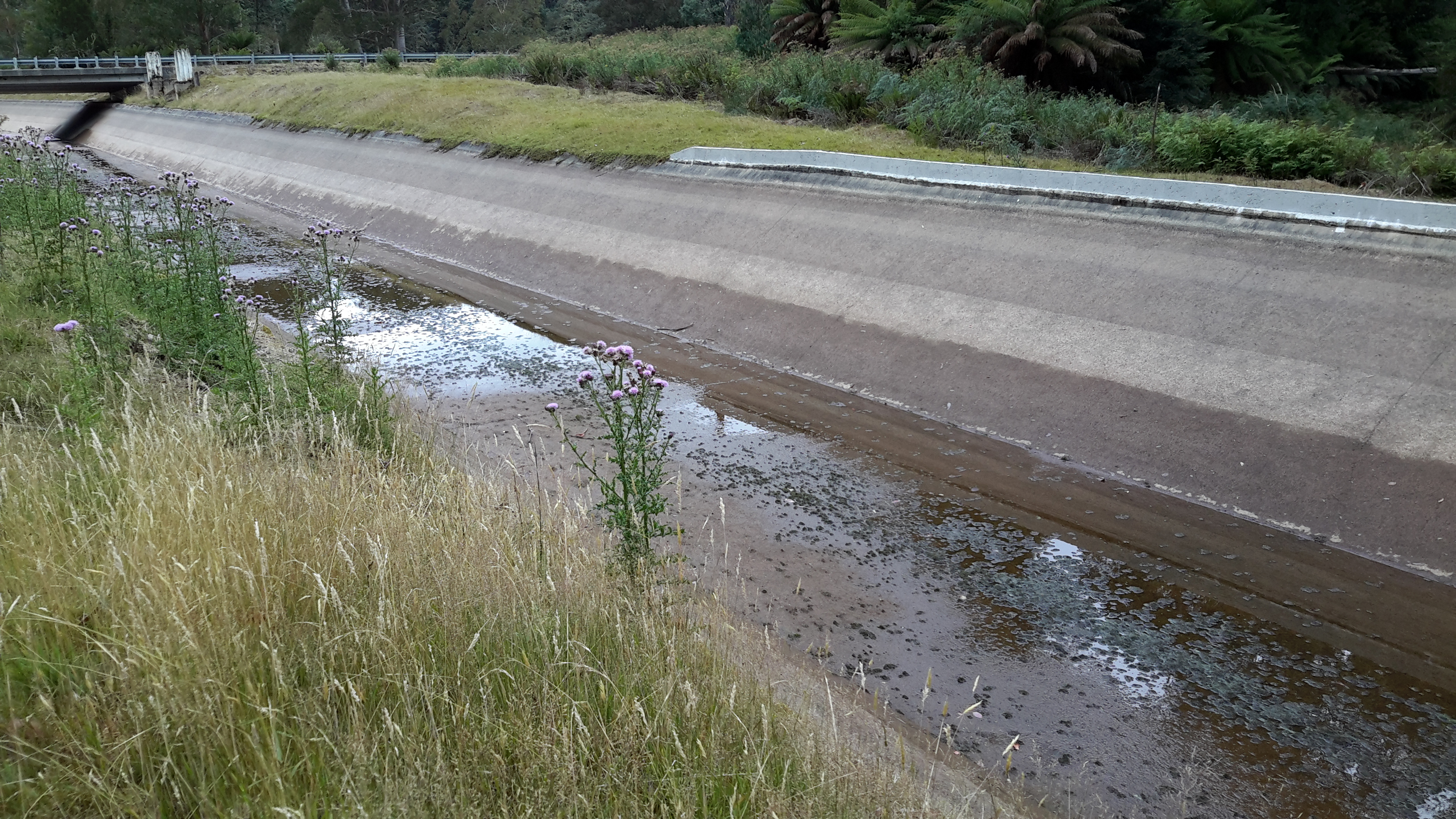
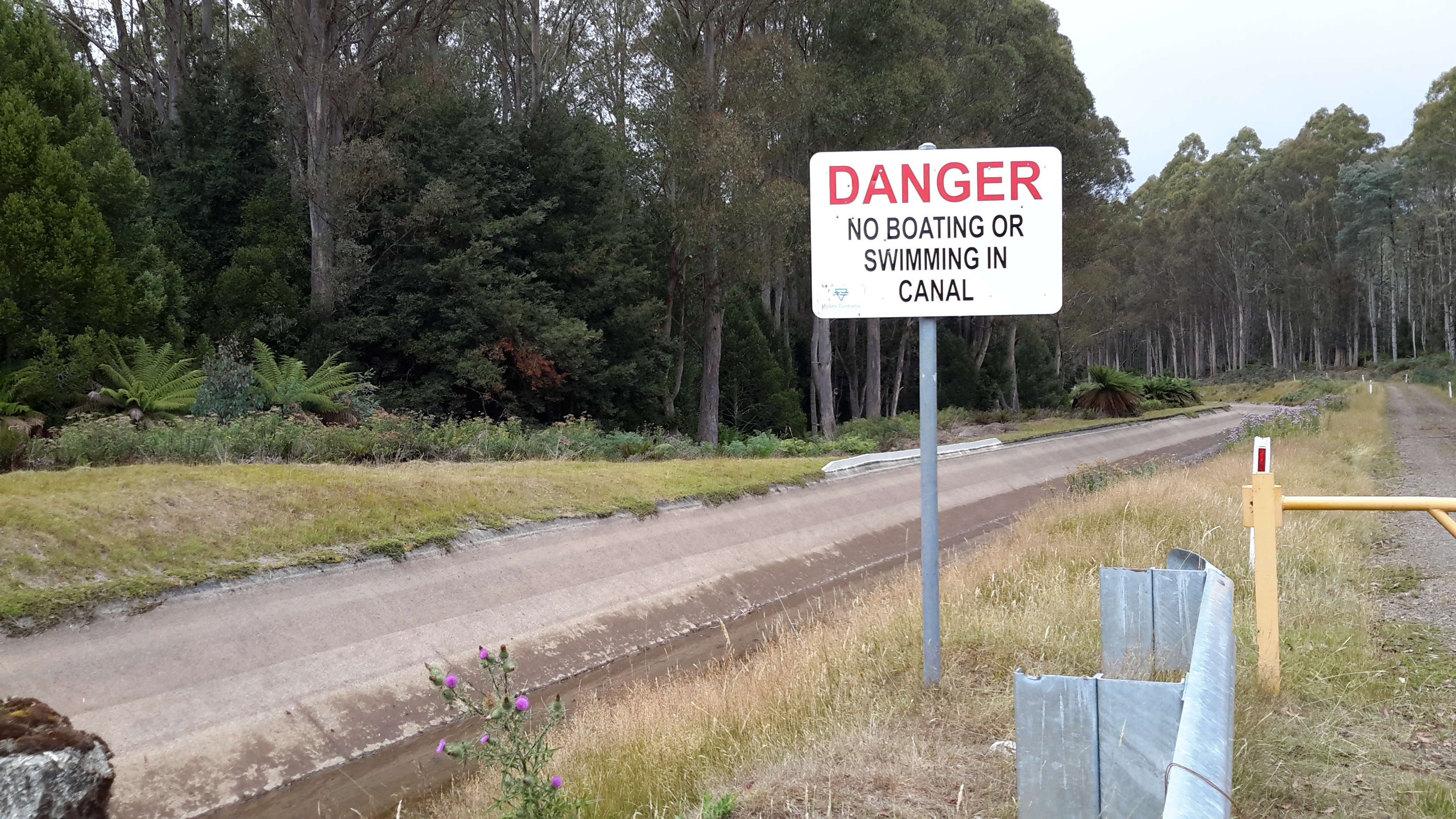
At 6.30 am, the day started with a drive from Hobart to the bridge crossing the Derwent River at Wayatinah. After parking his ute on the Florentine Road near the salmon hatchery at Wayatinah around 8.30 am, a friend drove him westwards along the Lyell Highway to the junction with Butlers Gorge Road. Under overcast skies on a cool day, Andrew began walking next to Tarraleah Canal No 1 around 9.30 am and continued until he reached the first crossover walkway about one kilometre further on. This location promised the shortest distance down to the Derwent river bed.

_dsc5676-1

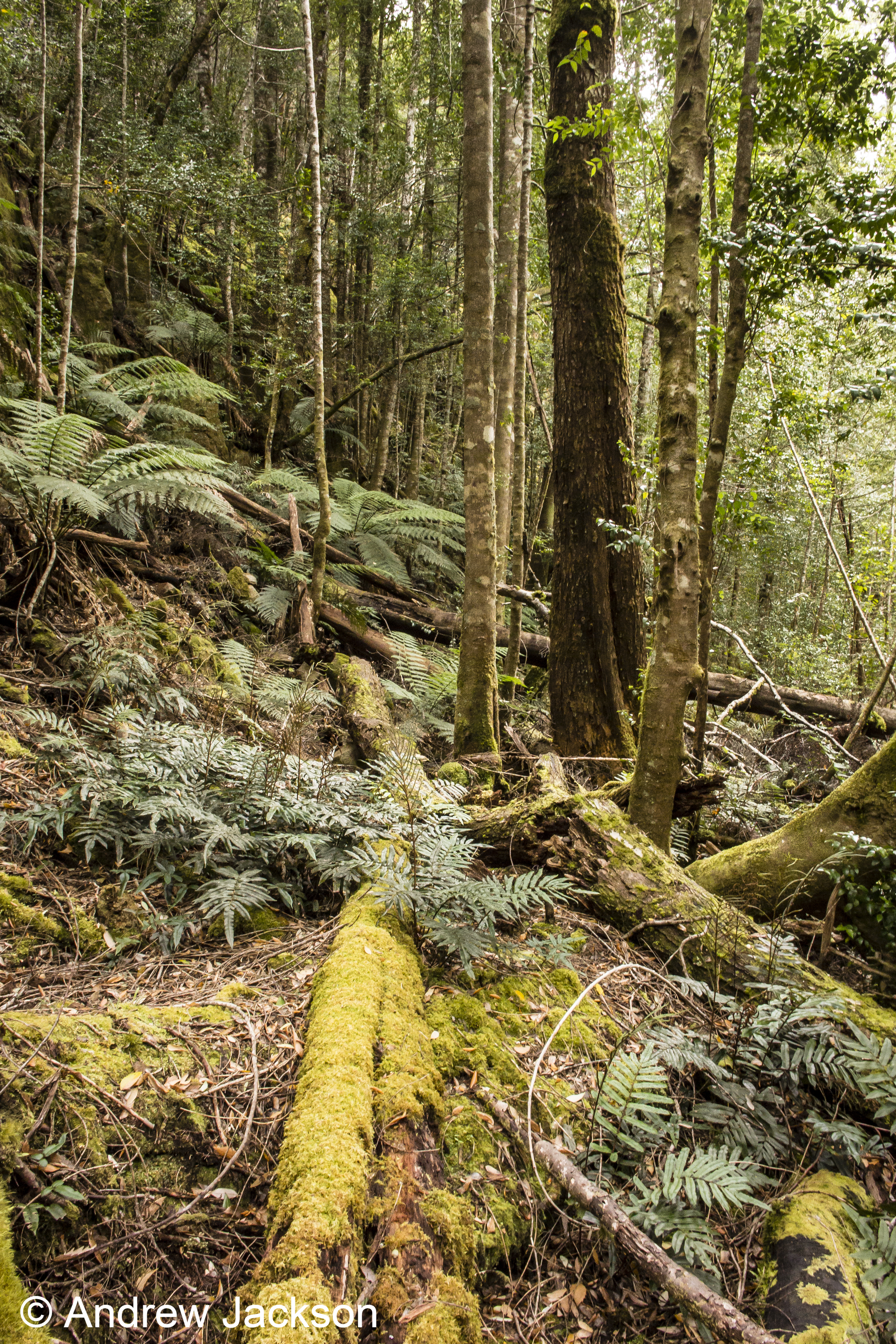
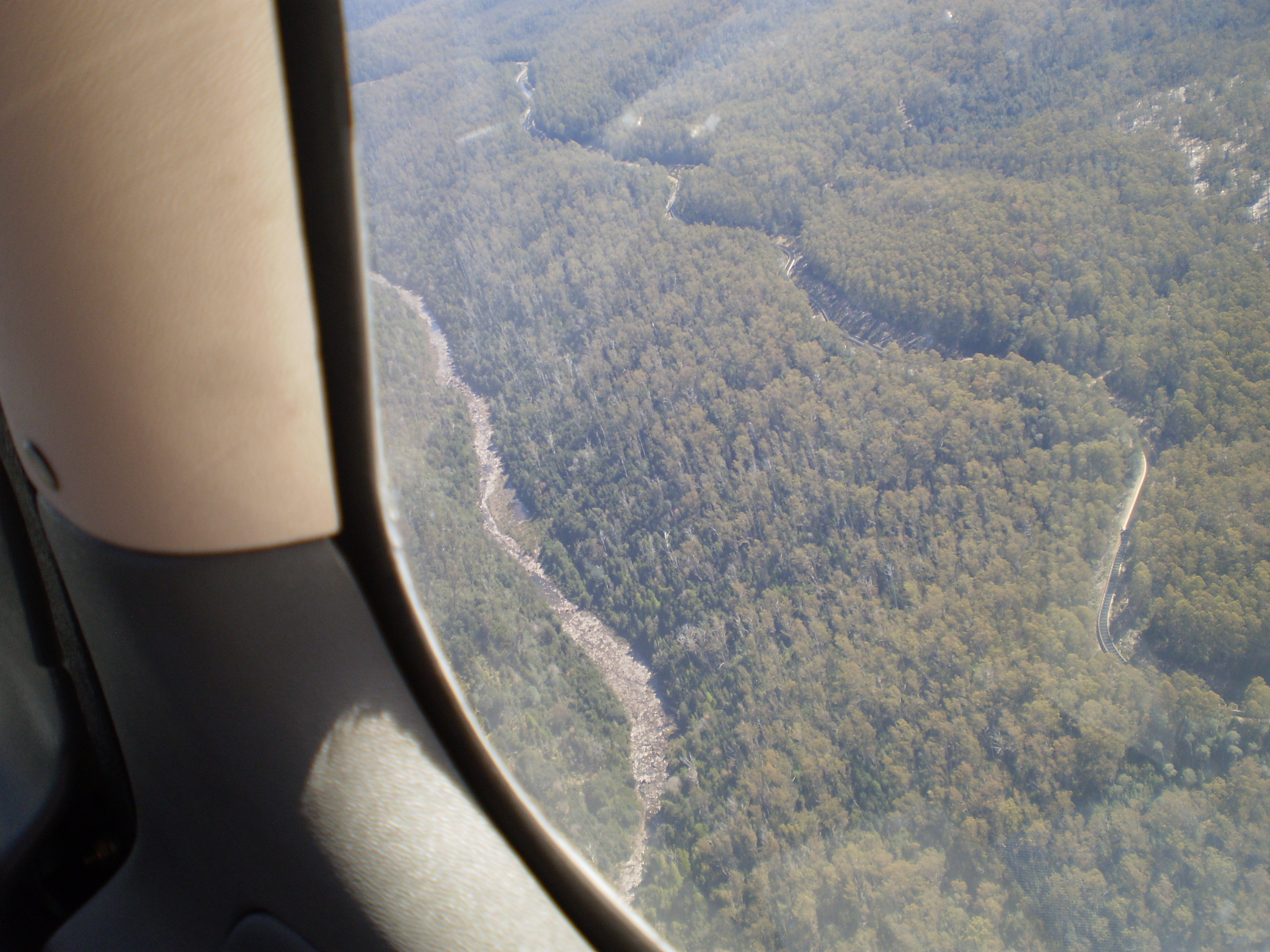
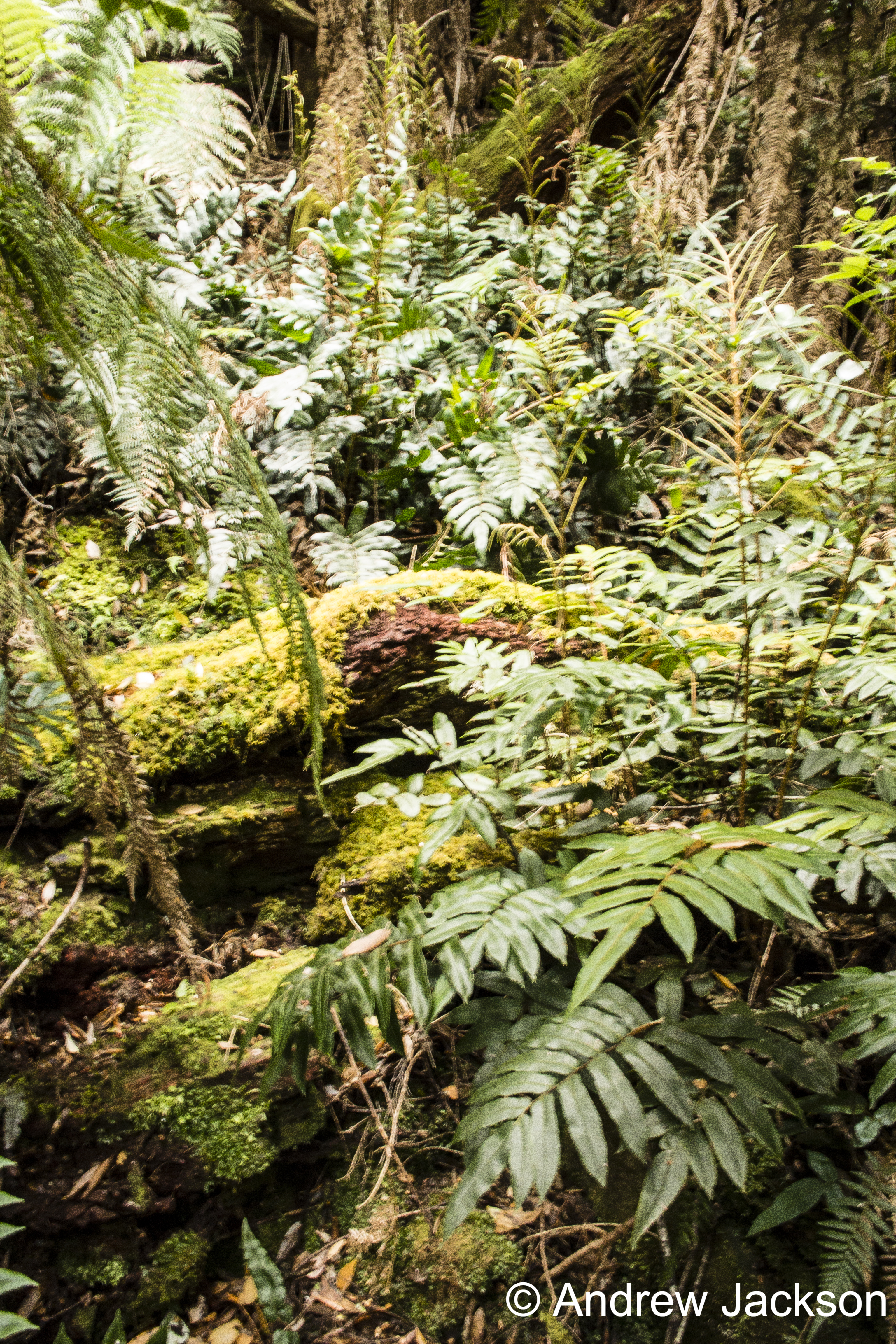
Andrew crossed, looked downhill and saw nothing but dense scrub ahead. He remembers remarking out loud “don’t dither, just do it. Don’t delay.  Here we go; just do it”.  At 10.10 am he left the Canal. Before stepping into the unknown, he spent time getting a GPS position fix and a magnetic bearing. Once set, he plunged into the thicket and took a series of sightings from one key tree to the next.  This allowed him to stay on his bearing, and meant he would be able to retrace his steps if the going was too tough and the forest impossibly dense.  The route down the steep slope passed massive tree ferns, smaller ferns, myrtles, mature eucalypts and the occasional Sassafras tree.  Many fallen trees littered the understorey and it was clear this was an old forest in a constant state of regeneration. Scrambling over or under logs and negotiating rocky bluffs was a normal part of the descent.

_dsc5677-1

_dsc5680-1

Half way down the steep incline,  it seemed that serious wind was blowing high up in the trees. Before long it was clear the rushing sound was the water of the Derwent River further below.  Once the river could be seen, then it was a comparatively simple process to choose the clearest path to the river bed.

_dsc5681-1

Tarraleah Canal No 1 walk – where is the water?

My walk started well with the Tassie Link bus depositing me on the Lyell Highway at the junction with Butlers Gorge Road, a very isolated spot.  The day was overcast and sufficiently cool to make for extremely comfortable walking.

20160218_101736.jpg

Instead of following Butlers Gorge Road I walked over to Tarraleah Canal number 1 and was stunned.  It contained no running water and green slime was growing at the bottom in sections.

20160218_102406.jpg

20160218_102403.jpg

A question pounded through my brain – where was ‘my’ Derwent River?  I was annoyed.  I was two hours’ drive from Hobart and returning home was not an option. I was here to walk my ‘choice’ of the Derwent River, yet no water flowed.  I humphed and sighed and decided to walk beside the Canal to Clark Dam despite the absence of water, and that would be my story.

Years ago Tasmania decided to sell its clean electricity supplies into the national grid and in tough times to buy in essential electricity supplies.  So an underwater pipe was built beneath Bass Strait, which separates Tasmania from mainland Australia.  In recent months the connection has failed, the Bass Link is yet to be repaired and our state has been unable to acquire additional electricity to meet our needs in the foreseeable future. Meanwhile with low water levels in our Hydro Tasmania dams, our local electricity supplies are in danger of being exhausted.  Therefore, when I saw the empty Tarraleah Canal number 1 I jumped to the conclusion that the water from Lake King William had been turned off; I thought this was a sign of our increasingly dire situation.  Later (and in a later post I will explain) I learned I was wrong.  The empty Canal had nothing to do with the Bass Link failure.

I laughed to see the warning sign.

20160218_101825.jpg

As later posts will indicate, even when empty this Canal is dangerous and should never be entered.

Tarraleah Canal No 1 walk – aerial views of the terrain

Aerial photos help to situate this part of my walk along the Tarraleah Canal Number 1.

Chantale’s first photo below looks across to Lake King William behind Clark Dam, and down onto the remnants of the meandering ‘dry’ Derwent river bed meander which can be seen in the glare near the lower edge.  The Canal winds its way next to a gravel road close by.  Her second photo shows the curving Canal and the gravel road, on which I walked, immediately to its right. Much further inland a yellow line indicates the gravel Butlers Gorge Road.

IMG_3876Clark Dam.JPG

IMG_3880

My photo below includes the old river bed, the Canal and the Hydro Tasmania gravel road.

20151028_115927.jpg

Michelle’s photos below helps you to appreciate the density and height of the surrounding bush. I stayed on the road and was immensely pleased not to be navigating through that wilderness.  The bush was stunningly beautiful to look at and to smell but would have been a nightmare to walk through.

PA280105Butlers Gorge rd.JPG

PA280107 Canal 1 and Butlers Gorge Rd.JPG


Possible locations where the Derwent River can be ‘touched’

I have compiled a list of those locations where I believe, with a vehicle, it will be possible to ‘touch’ the Derwent River occasionally along its length between Gretna and Lake St Clair.  Please let me know if any section listed below takes your fancy and if you would be interested to try it out.

Almost all sections include driving on bitumen highway, gravel roads and poor tracks. Some of these may be forestry roads.  If you wish to volunteer to take me to one of these sections (let me know on walkingthederwent@gmail.com), please feel comfortable that your car can handle the different conditions.  Of course, common sense will prevail and we will never push on if a road is too rough for your vehicle and your peace of mind.

If you are happy to help me reach my goal, albeit differently than originally expected, I would like to fill up your tank with petrol as some compensation.  You know my ‘walking the Derwent’ is a non-commercial project, but since I do not own a car nor drive, I need transport – and therefore, I am happy to cover the cost.

  1. On eastern shore – From New Norfolk drive along the Lyell Highway and then, not far past Gretna’s Sports ground, take a left turn into Clarendon Road and drive to farmstead buildings about 250 metres from the river on a hill. Perhaps 140km return trip.
  2. On western shore – From New Norfolk drive along Glenora Road, and turn left at Bushy Park then right onto Meadowbank Road over the Tyenna River then next to Derwent, then on over Meadowbank Creek to a hill top with buildings. It may be possible to continue quite a way on this road. Minimum 130 and maybe up to 160kms return trip
  3. On eastern shore – From New Norfolk drive along the Lyell Highway and turn left off the Highway onto Meadowbank Dam Road. Continue to dam and southern end of Meadowbank Lake. At least 170 kms for round trip.
  4. On western shore – Travel from New Norfolk and turn left into Gordon River Road at Bushy Park, then turn right off Gordon River Rd into Ellendale Rd and then right onto Rockmount Road before you reach the township of Ellendale. There seem to be many dirt forestry tracks to Meadowbank Lake. At least 170kms return trip and maybe 200kms return or more depending on roads.
  5. On western shore – Travel from New Norfolk and turn left into Gordon River Road at Bushy Park, then turn right off Gordon River Rd into Ellendale Rd and drive on through the township of Ellendale until you reach Dawson Rd / Dunrobin bridge over Meadowbank Lake. Turn left before bridge and it seems we can drive 2kms further up along the Lake edge. Return to Ellendale Road, cross bridge and connect with the Lyell Highway. At least 170kms return trip and maybe 200kms return or more depending on roads.
  6. On eastern shore – From New Norfolk drive up Lyell Highway and continue past the left turn off to Dunrobin bridge and afterwards and to the left there are a number of dirt tracks seemingly without gates. After a while these tracks/roads only extend to the Ouse River and not the Derwent River so map consultation is crucial. At least 180kms return and maybe over 200kms return depending on how many side roads/tracks can be driven along.
  7. On eastern shore – Drive up Lyell Highway past Ouse then turn left at Lake Repulse Road. Continue to intersection with Cluny Lagoon Road and turn left and go to Cluny Dam. Return to intersection and continue on Lake Repulse Road to the Repulse Dam. Can cross a bridge and continue back south around Cluny Lagoon to a ‘settlement’ named Cluny.  Perhaps could access this road from the Ellendale Rd on the western shore? By driving north from Repulse Dam along Dawson Road/then renamed Thunderbolt Road it seems we can take right hand detours to Lake Repulse. Over 200kms maybe 250kms or more minimum round trip.
  8. On eastern shore – Drive up Lyell Highway past Ouse, over the Dee River until the sign appears for a left turn at Catagunya Road. Drive down to Catagunya Dam. 200kms minimum return trip
  9. On eastern shore – Drive up Lyell Highway past Ouse, over the Dee River, past Black Bobs and turn left at Long Spur Road. This runs around Wayatinah Lagoon. Go past the intersection to Wayatinah Dam, turn left and travel to Wayatinah Power Station on Lake Catagunya. Return to intersection and turn left and travel to Wayatinah Dam. Cross bridge and continue on to Wayatinah township. Access dirt tracks in the vicinity of all. Drive south from the Wayatinah Dam on the western shore along the Florentine Road but don’t bother crossing the Florentine River because the road goes inland away from the river. Minimum of 230kms but most likely  at least 300kms round trip.
  10. On eastern shore – Drive up Lyell Highway and when you reach a canal passing under the road, and where the road turns right to go to Tarraleah, go straight ahead on Butlers Gorge Road. Note there are limited roads off and around going closer to the river near that intersection. Continue along Butlers Gorge Road for 10-15 kms heading for Lake King William. Reach Clark Dam and Power Station. Continue onto Switchback Track along side of Lake King William. This track stops and you have to return the same way – swamp separates you from the track north about 500 metres away. This would be a big day and I suggest take overnight accommodation at Tarraleah before setting out. PERHAPS it is possible to walk across the swamp and then walk about 7 kms to Derwent Bridge. Unknown over 300 kms return trip.
  11. On eastern shore – Drive up Lyell Highway to Derwent Bridge and continue past to left hand turn off on the western side of Lake King William and drive the track to the lake. 360 kms return trip minimum.
  12. On eastern shore – Drive up Lyell Highway to Derwent Bridge. Walk from the bridge over the Derwent River near the township of Derwent Bridge to St Clair Dam at the bottom of Lake St Clair Lagoon where the Derwent River starts. Walk to Pump House Point and St Clair Weir at the southern end of the Derwent Basin. 350kms return trip minimum.