Tag Archives: Derwent River

22 Aug 2014 Heading for the start of the first walk at Cape Direction – Posting 5 of 8

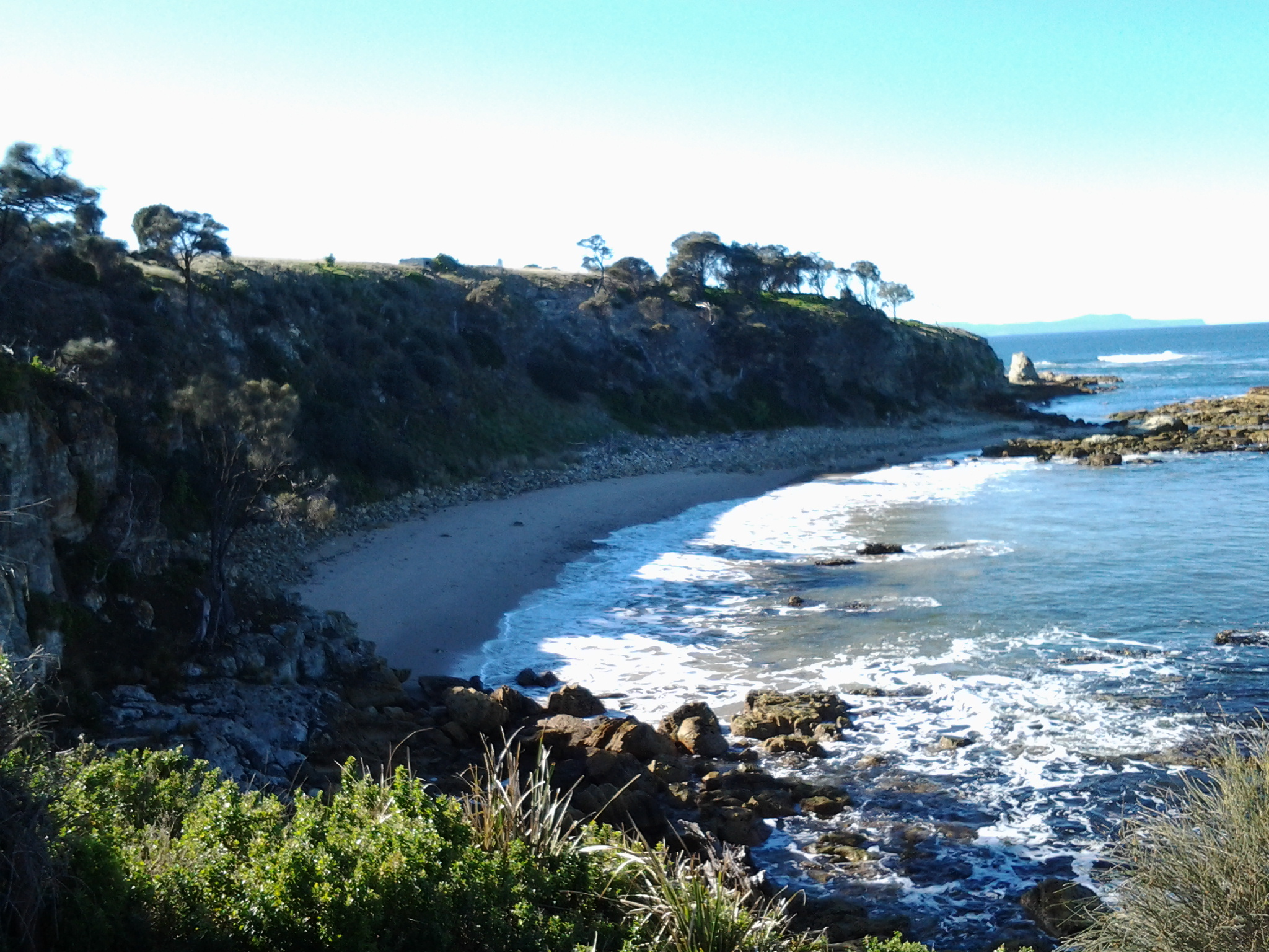
The photo below shows Cape Direction. To the left of the headland trees is a concrete bunker.

20140822_095939

Heading toward Cape Direction, I walked along a vehicular track eastwards and down onto the firm sand of the beach at Pot Bay.  Large Gulls either Pacific or Dominican patrolled the beach, letting a mix of Pied Oystercatcher and Sooty Oystercatcher birds have a run around.  The protruding flat sandstone rocks on the beach featured empty oyster shells.

 20140822_095103

20140822_095416

 At the end of the beach I clambered up the rocky earthy banks amidst a rich layer of fleshy vegetation that looked good enough to eat. I knew that the pigface plant with bright pink flowers open to the sun was edible, but what about the rest.

The photo below shows a swathe of blooming pig face on the Pot Bay side of Cape Direction.

20140822_095628 

What did the original aboriginal people eat? I would be very interested to learn whether some of the other plants could be used as food.

I had been warned that most of the old gun placements on Fort Hill were out of bounds, and again a high mesh perimeter fence made that clear.  But I was able to wander towards the one remaining structure outside this fence – one without tunnels. I waded on through high grass and onto another vehicle track that lead uphill to the remains of a massive concrete gun placement structure.

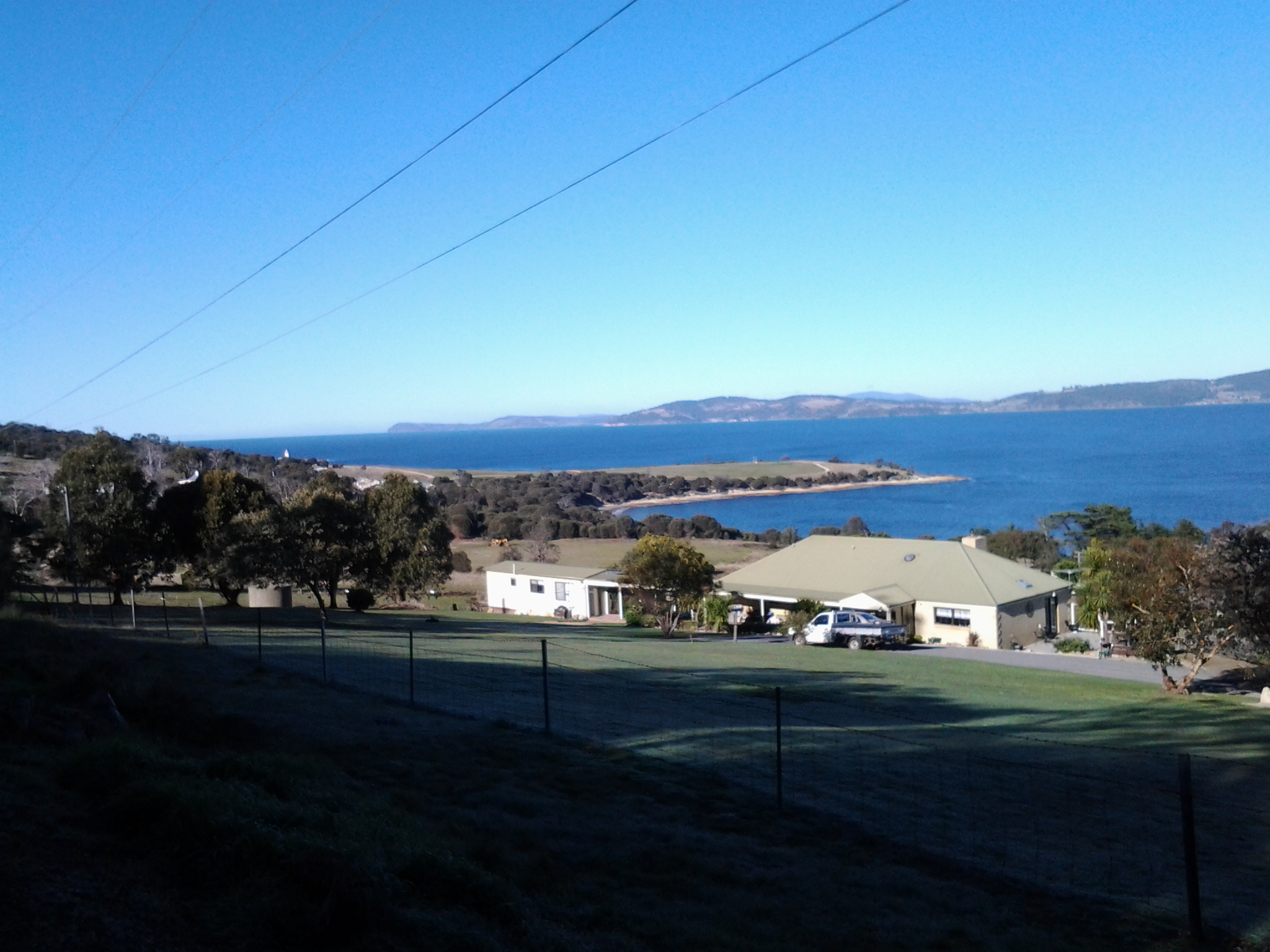
The photo below shows the concrete structure. The Iron Pot lighthouse can be seen in the distance.

20140822_100305

As I wandered inside the structure, it made no sense to me, and with no information to hand I was left puzzling as to why it was surrounded on all sides by rock and earth so the soldiers would not have been able to see an enemy coming towards the Derwent leave alone fire on such a ship.  Perhaps I am the first non-defence services visitor (can that really be true?) and everyone else who has visited perfectly understands how the building was used. 

From this structure it was a short distance east to open and exposed Cape Direction – the starting point for my walk along the Derwent.  Opposite, almost linked to the mainland at low tide by a series of rocky reefs, was the Iron Pot in all its glory.

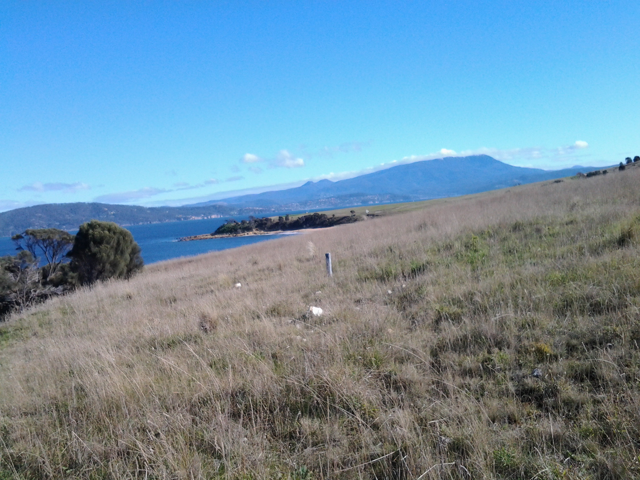
The photo below shows Mount Wellington above Hobart, past Cape Deliverance and taken from Cape Direction.

 Towards Cape Deliverance and Mt Wellington

22 Aug 2014 Arrival at Fort Direction – Posting 4 of 8

After 20 minutes walking from the bus, I stood at a high mesh perimeter fence with a large open gate and massive signs telling me that the land beyond was the property of the Defence Services and ‘Trespassers will be prosecuted’. Cape Direction was so close, and now my access even to the beach from this location was thwarted. Using a number on one of the signs, I phoned the caretaker of Fort Direction (the cluster of buildings between me and Cape Deliverance and Cape Direction) and asked if the signs really meant what they said.  Yes they did.  This is a serious defence location and casual visitors are not permitted. When the caretaker informed me I could take my car and access the beach from Blessington Road, I let him know I was a walker.  He was surprised. So many people don’t walk these days and are surprised when they come across someone who does.  Not missing a beat, he offered to drive to the gate, collect and take me through (the militarised zone – my expression) and drop me at the Lone Pine Memorial on Cape Deliverance. From there I could walk in select places and then return to South Arm via the beach.

I do love the world. Something so good always comes out of something so problematic (and if this isn’t always true, I choose to forget any exceptions). The caretaker was friendly, amiable and chatted generously. I am so grateful for his help.

 Apparently while the wooden buildings of Fort Direction don’t get a great deal of use except by cadets, they have historic value and have been maintained as the result of very strong local community advocacy. But close by, under lock and key are stores of live ammunition.  I wouldn’t have been interested in any, but I guess others might if casual wandering around had been permitted.  Originally the ammunition was stored in the nearby tunnels beneath the old gun placements on Fort Hill (which was out of bounds) – a very secure place and if an explosion had occurred any damage would have been localised.

Yesterday, I trawled the internet to try and understand what Fort Direction was all about. If you are interested a simple google will bring up a great deal of information and photographs.

The caretaker drove me out onto the flat exposed and open expanse that is modern day Cape Deliverance. It is above sea level but is not high enough to have the handsome cliffs that I could see across the Derwent when looking at the near Pierson’s Point and surrounds in the Tinderbox area. The first thing I noticed were two tall white flag poles, without flags, standing at the end of a large area. A part of me considered that if two more poles were added, a game of one ended AFL footy could be played here. The ground was extensive and very flat. 

The poles framed a remembrance structure with the words Lest We Forget. In an arc at some distance were seven pillars. On each was the name of the seven Australian servicemen who were awarded the Victoria Cross as a result of their actions at the Battle of Lone Pine near Gallipoli. This was the significant battle fought between Australian and Ottoman Empire  forces during the First World War between 6 and 10 August 1915.  I asked my driver how this memorial came to be here considering none of the 7 were Tasmanian, or ever visited Tasmania, leave alone were locals. The question surprised him, and left him worried. Not only did he not have an answer, I sensed he wondered whether the decision to install this memorial in an isolated place without direct connection to the people of South Arm, was appropriate. 

He left me at the Lone Pine Memorial and I tried to see it clearly with the wind lancing my face.  A melancholy spot. But strikingly beautiful. The caretaker had told me that the physical nature of the location and its views had something in common with the Dardenelles, and that most RSL guys thought it was particularly appropriate site for the memorial.  Anzac Day brings 700 plus people to this windswept site for the dawn service. I can appreciate how the landscape would make the ceremony quite powerful.

The photo below looks seaward from the Lone Pine Memorial on Cape Deliverance towards the Iron Pot lighthouse.

 20140822_094232

The photo below looks across from the Lone Pine Memorial on Cape Deliverance towards Piersons Point and the Tinderbox area – the starting point for the Derwent River on the western shore.

 20140822_094317

The photo below shows the single pine planted as part of the Lone Pine Memorial. In a cage.

20140822_102521

22 Aug 2014 Arriving in South Arm and starting the walk – Posting 3 of 8

At 8.50am the bus was darting past the Clifton Beach turn off and then, after speeding across the low lying road of the isthmus, a little after 9am I was stepping off the bus opposite the South Arm shop. For anyone following in my footsteps, if you need a public toilet, there is one near the beach and the South Arm Shop can point you towards it.

The photo below shows the South Arm Shop, a multipurpose village convenience store.

20140822_112154

As I stepped off the bus, a wonderful wedge of water beckoned me. This was the Derwent River showing itself down the end of a track to the beach. That track started from a roadway that passed by the Cenotaph where the road made a 90 degree angle bend to head onwards to Opossum Bay, all a short way down from the bus stop. But instead of walking towards the river, I turned back along the main road to find my starting street.

My main task was to reach the starting point of the walk along the Derwent, and then to walk as far along the river’s edge as my feet would carry me before the return bus arrived. From maps it was clear I could walk along the Fort Direction Road to the starting point at Cape Direction and then I could return via the coast for a change of scenery. Fort Direction Road was a few metres away from the bus stop.  As I walked up the road (which wasn’t level and wasn’t going downhill) the expression that this was ‘a decent short pull’ came to mind. I seem to remember Nan used the word ‘pull’ when talking about getting a team of bullocks up a short steep hill. Thankfully the pull only lasted about 5 minutes before I was able to follow a gentle upward incline in a more relaxed fashion.

Coming over the rise of one hill, I was surprised to see the crisp white lighthouse with its sharp red painted top on the Iron Pot, not far over the water from the flat top of Cape Deliverance. With the fresh smogless air, the outlines were smart and the tiny rocky islet seemed so close to the mainland.  I was thrilled to see it.  For years I have heard how the Sydney to Hobart Yachts ‘round’ the Iron Pot to enter the Derwent River every December. Now I can visualise this happening. What a sight it must be if the yachts are bulging with colourful spinnakers. Perhaps visiting the area between Cape Direction and Cape Deliverance for such a spectacle should be added to my ‘to do’ list.

My research unearthed interesting tidbits about the Iron Pot. The http://www.abc.net.au/local/stories/2008/11/03/2408589.htm tells that “From 1832 until the early 1880s the lighthouse was the main feature of the site, warning ships of the treacherous waters through which they were navigating. Then, in 1884, it was decided to build a home next to the lighthouse for its keeper James Parkinson and his ever growing family. The home was built only 20 feet above sea level and made the most of a minimal amount of land. One of the greatest challenges for the residents came in 1895 when 90 feet waves battered the coastline. “Waves were breaking over the top of the lighthouse. The people that were in the house moved into the lighthouse for safety. The storm left kelp hanging in the iron railings on top of the lighthouse. Stories also claim the Parkinson home was found to have substantially shifted on its foundations following the extreme conditions.” The site http://www.seasidelights.com.au/au/tas/ironpot.asp?fState=TAS gives some dramatic stormy photos.

The photo below was taken from Fort Direction Road. The flat headland is Cape Deliverance. The white Iron Pot lighthouse shows near the horizon over the slope of Fort Hill.

20140822_092426

The photo below shows a piece of Cape Deliverance on the left and a piece of the Tinderbox area on the right. In between the two prominences, flows the Derwent River.

20140822_092437


22 Aug 2014 Setting out to travel to South Arm – Posting 1 of 8

The first stage of my walk along the Derwent River took me away from home for 7.5 hours. This included walking to the tip of the eastern side of the mouth of the Derwent River in the South Arm area, then gradually plodding northward on the eastern side of the river.  I am exhausted but exhilarated. When I stand on my feet or move around, my body screams ‘sit down, stay still, and never move again!’

My walk started at Bellerive when I jumped on the Metro bus No 640 that departed from Hobart at 8am. The sky was blue and cloudless but I was rugged up and beanied to avoid the early morning chill. I was nervous, and queasily excited. This felt so much like travelling into the unknown when overseas; an unknown destination (years ago Ru took me to a weekend market at South Arm, and prior to that I had driven down and back to Opossum Bay – but I have never spent time in or explored the area), unknown bus stops and reliability of timetables, new maps, unknown people and circumstances, and no idea how long it would take me to cover the stage I had planned.  The return bus was leaving Opossum Bay at 2.02pm and the next one wasn’t leaving until 5.55pm. I wanted to time my walk to catch the earlier rather than the later bus because I knew my feet wouldn’t last long. I calmed myself with the realisation, that unlike the situation with most of my travels, I had a mobile phone and sufficient funds for a taxi if need be.

Nothing I imagined turned out to be.

I had thought there would be no one on the bus because everyone would be heading towards Hobart.  Of course, this was a dopey idea. But I was the only passenger from Lauderdale onwards as the bus sped along the uneven bitumen rattling strongly (these buses are not designed for nonurban areas).

What did I see during the bus trip? Peak hour traffic streaming towards the city. The Bridgewater Jerry steaming down the Derwent to the sea. The early morning sun in the driver’s eyes. Hard winter sun on the new growth on gum trees.  Yellow floral masses on wattle trees.  Dew still sparkling on wet grass. Rare smoke trails from occasional chimneys.  Sheep, horses, llamas, billy goats, olive trees and small house orchards. It was a simply gorgeous day to behold.

The bus route deviated through the back streets of Rokeby, a tiny suburb still 30 kilometres from Opossum Bay. From the upper streets the blue flat glittering expanse of Ralph’s Bay (which is fed by the Derwent River) was stunning.

Acknowledgement of Country – to the Moomairremener people

I will be walking on the land of the Moomairremener people as I walk along the eastern side of the Derwent River.  Therefore, 

“I acknowledge and pay respect to the Tasmanian Aboriginal community as the traditional and original owners and continuing custodians of this land.”

The first people to live in Clarence were the Moomairremener, a band of the Oyster Bay tribe. Their home was all of present-day Clarence as well as Pittwater. In summer the Moomairremener went up the Derwent to the New Norfolk area to hunt, while the people there came down to the coast. In autumn they returned to the coast. Europeans later recorded some Aboriginal place names: More.der.tine.ner and Reemere were South Arm, Trum.mer.ner pine.ne was Droughty Point, Nannyeleebata was Rokeby, Mole.he.ac Kangaroo Bluff, Lore.by.larner was Betsey Island, and Ray.ghe.py.er.ren.ne was one name for the Derwent River. The Moomairremener people continued their usual life in Clarence until 1803. (http://www.ccc.tas.gov.au/webdata/resources/files/FINALClarence_01_to_1805.pdf)

Planning the first walk

Thanks to Je I was reminded that the grid on a map represents a distance and so, before I started fancifully imagining huge distances could be covered in a single leap, I have slowed down and thought through what is possible. And also what is desirable considering public transport times.

I have made the decision to start on my side of the river, the eastern shore of the Derwent. While stages along the river might be taken in any order, making a start on this epic journey at a key point seemed like the proper thing to do. I will start at the mouth of the river.  I am sure my decision as to where the mouth of the Derwent river starts will be controversial. But this is my walk. My Derwent River walk. Having consulted the maps, I can start where I think it is appropriate.

Previously I have remarked that all walks must be able to connect with public bus services – I don’t own a car, and I realise other future walkers of the Derwent might want to travel without worrying about car ferrying to get them to start and finish points. I accept the bus timetables may limit my possibilities and that I may need to walk additional kilometres simply to reach starting points, or after a finishing point along the Derwent. However, I know I will see and experience additional wonders that someone travelling in a car might miss.

Tomorrow morning the 8.09 Opossum Bay Metro bus from the Eastlands bus stop will convey me to South Arm where I plan to follow the Fort Direction road and continue on to Cape Direction.The Cape will be the starting point of my walk along the eastern side of the Derwent River. Tomorrow’s walk is a study in getting a feel for the time it takes to cover territory in a plodding easy way. It will also give me an indication of the reliability of the State Government maps. I expect to cover about 6-7 kilometres including historical sites, but only a portion of that will be along the Derwent.  This area is serviced by an infrequent bus run and I am aware that I need to be back at a bus stop for the next bus departing Opossum Bay at 2.02 pm.

Today is bright and sunny with that gorgeous cloud free Spring look. I am sorry that I hadn’t planned to start walking today. But my excitement is now building for the start of this epic adventure tomorrow!

The Bridgewater Jerry … or is it Gerry?

This morning the Bridgewater Jerry obliterated my view of much of Hobart from the eastern shore. The Derwent River stopped being visible. In the sunshine, its fast moving roll down the river towards the sea was spectacular.

The Bridgewater Jerry moving down the Derwent River with Mount Wellington in the background. Taken from the eastern shore 17 August 2014

The Bridgewater Jerry moving down the Derwent River with Mount Wellington in the background. Taken from the eastern shore 17 August 2014

2014-08-17 08.51.00 2014-08-17 08.51.29

The internet offers many sources of further images and information. Examples are listed below (I was surprised to learn the Jerry has its own website, a public sculpture has been created in its honour, and Australia’s premier dictionary contains an entry. That’s not all – have a look at the websites listed below).

http://www.bridgewaterjerry.com/  … The Jerry has its own site showing one glorious photo but with no identifiers, date or other information.

 http://prelive.themercury.com.au/article/2012/07/02/342041_tasmania-news.html … In 2012, the local newspaper The Mercury published a short story with a couple of views when “ ‘Ol Jerry rolled into town”.

 https://www.flickr.com/photos/esereth/9252562361/ … this Flickr site offers a sensational air view of the jerry

 https://www.youtube.com/watch?v=gDsVB5Nz3K8 … thanks to Damien Brockie’s time lapse video you can see the movement of the fog down the Derwent river heading towards the sea.

 http://trove.nla.gov.au/ndp/del/article/26190783

This site shows a scanned copy of a 1946 newspaper article which described the draught as keeping ‘the thermometer at freezing point’. The article pointed out that the township of Bridgewater has been libelled because the fog starts further up the valley. Apparently, at the inland town of Bushy Park the fog is known as the ‘Bushy Park Blizzard’.

 http://www.abc.net.au/local/stories/2009/05/13/2569108.htm  …..

In May 2009, Carol Raabus wondered where the name ‘Bridgewater Jerry’ came from.  She reflected that “It’s that time of year when the mornings are crisp and you just don’t want to get out of bed. You look out the window and see nothing but a thick fog, blanketing Hobart’s suburbs from the Hobart docks, up to Bridgewater and further up the Derwent Valley. But where did the fog get its name? And should it be spelt ‘Jerry’, or the less common, ‘Gerry’? One theory of the origin of the name is that word ‘jerry’ came from London, where it was thieves’ slang for mist or fog, and the term was transported to Tasmania with the convicts. David James writes in The Companion to Tasmanian History that the first written reference to the fog, although not using the name Jerry and not coming from Bridgewater, was in 1821 when Governor Macquarie wrote he couldn’t leave Austins Ferry for Hobart until 12.30 one day, due to the thick fog.”

 http://www.utas.edu.au/library/companion_to_tasmanian_history/B/Bridgewater%20Jerry.htm ….

David James (2006, Centre for Tasmanian Historical Studies) declared “the ‘Bridgewater Jerry’ is a fog which occasionally affects the Bridgewater Hobart area. At night, in cooler months, cold air drains down the mountains of southern Tasmania as katabatic winds and collects in the Derwent Valley. Fog will form if this invading air is moist and cool enough. It drains out of the valley in the mornings, blowing the fog with it. The fog mainly affects the Derwent and the northern and western suburbs of Hobart, but occasionally reaches the Eastern Shore.

https://www.macquariedictionary.com.au/resources/aus/word/map/search/word/Bridgewater%20Jerry/Tasmania/

The Bridgewater Jerry has an entry in Australia’s Macquarie Dictionary. “A dense, remarkably compact stream of fog which occasionally rolls down the western shore of the Derwent River (presumably from Bridgewater) into parts of Hobart.

  • Contributor’s comments:A front of fog Cold air drainage condensing. Usually ‘Bridgewater gerry’ describing the phenomena on the Derwent River from Bridgewater to Hobart but I have often heard it generalised in southern Tas. Not in any Tas lexicons. Suspect origin is post-WWI Gerry = German and looks like a gas cloud. The effect usually is that a bright clear and crisp Hobart morning swamped by cold fog flowing down the Derwent from Bridgewater: “Did you see the gerry running this morning? I was on the bridge when it hit.” Generalised: “Careful about buying a place in that valley, there might be a right old gerry running down there in the winter.”

  • Contributor’s comments:The Bridgewater Jerry gently rolls its way down the Derwent at the start of a winter day, often shrouding the low-lying riverside suburbs for most of the morning. Those people living in Hobart’s hillside suburbs would often be basking in brilliant warm sunshine before plunging into the dense, wet and cold on their way to work or school.

  • Contributor’s comments:I believe this term comes from the days when the Bridgewater Causeway was being built by the convicts – there was one named “Jerry” who was always smoking a pipe leaving a cloud behind him. Therefore when a fog was seen on the river it was associated with Jerry’s pipe.”

 http://www.arts.tas.gov.au/news_archive/unlikely_icon_celebrated_in_sculpture  … The Bridgewater Jerry, a unique fog that rolls down the Derwent Valley, has been immortalised in a public art project led by artist Tony Woodward.  Unfortunately all the links to an image of the sculpture, its location and other information do not work.  Where is this sculpture?  Does anyone know?

MONA is a key destination on the edge of the Derwent river

I am excited that today I will be travelling by a series of local Metro buses to MONA (our wonderful comparatively new, Museum of Old and New Art – which incidentally also houses ancient Egyptian art). The award winning architectural edifice sits on the banks of the Derwent river in Hobart’s northern suburb, Berriedale.  In the future, one of the walking stages will include passing by MONA.

Today, however, the only walking to be done involves getting to bus stops, and then walking up the driveway past Alcorso’s old house and the green leafed rows of grapevines to the new museum. Inside a treat is waiting for me: Synaesthesia. This is where a select few visitors will be asked to submerge themselves in a ‘reverberating, subterranean private playground’. Presented by MONA and the Tasmanian Symphony Orchestra, Synaesthesia will create an immersive experience for its patrons with musicians spread out across the entirety of the museum.  This is edgy stuff and having attended one day of the inaugural event last year, I can’t be sure what lies ahead – and therein lies the attraction.  I do know the Tasmanian Symphony Orchestra chorus will be giving me a new experience when they sing in total darkness while listeners are contained in an unlit room: Black Bach.

A new idea – starting out

A year or so ago, I read the true story of an English man who walked the length of the Thames River in England. He did not start one day at one end and continue walking until he reached the other end. Instead the walker fitted many stages of the walk around his normal working life. Through his eyes, and via his words on the page, I discovered a new way of seeing and understanding the everyday world one step at a time.

Half a world away in Hobart Tasmania Australia, the mighty river Derwent wends its way from further north moving south over approximately 249 kilometres past Hobart towards the sea. Last weekend, I realised that if I could walk the edges of the Derwent, then a wonderful adventure might unfold.

As I reread the above, my writing seemed unimpassioned and lacking the excitement I feel about this idea.  How fabulous to walk along our wonderful river with all its changing temperaments and colours; on some days to walk beside its ruffled surface or its mirror sheen. To look across at parts of the city, the hills and the mountain.  To enjoy the bobbing and sails of the yachts. To be reminded that I live in this marvellous place.

And when I walk, I want to share my discoveries. I will write the story of the walk firstly on a blog followed by a later publication in a hard copy format – complete with photos.  In addition, I will align the walk with the various set down and pick up points of commuter buses of the public transport system. In this way, I will make the walks accessible for anyone without a car.

Alive with the idea, I alerted Ju and Jo. I knew they would contribute valuable information. Already the ideas are flowing.  Immediately, Ju expected to walk some stages with me – an obvious and appropriate response.  I expect other friends may wish to join some stages.

It is unlikely the stages will be walked sequentially. Rather we agreed that I should buy detailed maps on which to mark out the length and track of distinct stages. Then, depending on the weather of a day or my mood, I can select the stage that best meets the situation.  Stages will not last more than a day, but the length of any stage may vary. In winter a stage may last a few hours.  However, during the long days of summer, a stage may last many hours.

The walks will not always be on the rocky or sandy foreshores of the Derwent river. Sometimes these river edges may be place for our footfalls. At other times we may cross grassy slopes over hills or pass along the concrete pavements or bitumen roads of suburban streets. On occasion, permissions may be needed to pass through private land.  But such possibilities are ahead.

Each walk will be an incremental path through unknowns. Only once the length on both sides of the river has been covered on foot, can the patchwork of stages be brought together and moulded to tell a story.

Today I purchased five maps: New Norfolk (5026); Richmond (5226), Hobart (5225), Taroona (5224) and Blackmans Bay (5223). Collectively these cover a small part of the length of the Derwent river.  The initial aim will be to determine the walks from the sea ends of the river at a point in the Blackmans Bay suburb (on the western side) and near the township of Opossum Bay (on the eastern side) then continuing upriver and finishing at some point in the vicinity of New Norfolk.  Further west then north some of the river flows through untracked wilderness so that serious bushwalking plans will need to be developed for those distances.  The aim is to walk the most easily accessible bits first.

A wind ruffled Derwent River shows off the the pleasures of the water. being overlooked by snowcapped Mount Wellington

A wind ruffled Derwent River shows off the the pleasures of the water. being overlooked by snowcapped Mount Wellington