Tag Archives: Opossum Bay

The second stage of the walking tour

Tomorrow, Thursday 4 September, I plan to walk a second stage of my foot journey along the eastern shore of the Derwent river.  As with the first leg, I need to take Bus 640 that departs from the Hobart city bus mall at 8am and heads towards Opossum Bay.  I will jump on the bus once it reaches the eastern shore and, as before, I know I must be patient because it will weave through the suburbs of Rokeby and Clarendon Vale before passing Lauderdale, Sandford and South Arm (details of these great locations are in the earlier postings related to the first stage of the walk). My bus destination is the Opossum Bay Shop. From there I will walk north to Gellibrand Point via beaches, roads and open landscape.  I hope to be able to enjoy my pre-packed lunch sitting looking towards Mount Wellington before returning to the Driftwood Drive bus stop for my journey back towards Hobart. The morning low temperature is expected to be around 9 degrees when I arrive and rise to about 14 degrees around 1pm. The return bus leaves Opossum Bay at 2.02 so I hope it doesn’t rain before then.  Keeping my fingers crossed!

22 Aug 2014 Leaving South Arm and heading home, and final thoughts – Posting 8 of 8

On the return journey towards Hobart, the bus deviated via large mudflats into the town of Cremorne adding 5 minutes to the trip, then it dropped me at a Lauderdale bus stop for transfer to another bus (because the Opossum Bay bus terminates at Lauderdale) approximately 5 minutes later (with his two way communication, the bus driver alerted the other driver there was a transferring passenger to be collected). Once on the Lauderdale bus, the trip towards Hobart deviated through the suburb of Oakdowns and so a further 5 minutes was added to the journey. After the bussing and the walking I was home in Bellerive at 3.20pm.

In this series of blogs for the first walk stage, I have provided approximate times for various sections of my walk as an indication only. I am short legged and plod slowly (and towards the end I felt I was shuffling like an old man). If you are tall and can happily stride long steps faster, then my walk will not be sufficient to fill the time between buses.  In fact some speedy walkers may be able to continue through the Opossum Bay community and walk to the end of Gellibrand Point, the most western tip of this piece of land before Ralph’s Bay makes its inlet.  My next walk will be designed to complete that section, and then I should be able to advise as to whether fitting it all into 5 hours is possible for the able.

Since it is unlikely anyone else will have my success if they turn up at the gate of Fort Direction and get driven through the site, the only general public approach is to walk along Fort Beach having walked most of Blessington Road.  Based on the information I recorded, I suggest one way on this route from the set down bus stop to the Lone Pine Memorial will take an hour if you take time to enjoy the views and click photographs. Add the half hour return walk between Cape Deliverance and Cape Direction with its gun placement bunker and the whole excursion takes approximately 2 ½ hours.  As an alternative, you could spice it up by jumping the shore rocks like a goat, from South Arm to Fort Beach. I would guess another hour could be added to the duration of the walk.

I noted that the tide was going out while I walked, and that the high tide merged with the dune verges in places on Fort Beach. It made me think that on a high tide, this route might be impassable. In such a circumstance and if you had made the special trip and your heart was set on a beach walk, the expanses of the South Arm beach with their outstanding views, old pines shadowing parts of the dunes, and soft roaring Casuarina trees, would make a very attractive substitute.  You might be lucky, as I was, to see a giant fresh squid washed onto the beach being enjoyed by immature grey feathered winged large Gulls.

Many of our native birds are various shades of black and brown but we also have an array of colourful specimens. During my walk, the sun brought out not only the musical black and white Magpies, the hard cawing jet black Crows, but also plump pink and grey Galahs feasting on the ground, Mr Blue Wren flitting in and out of the shadows, a glorious Mr Robin with his red breast, and a flock of multi-coloured Rosella parrots.

My guess is that I walked around 10-12 kms including getting to the start and then continuing on.  But how much of the 249km length of the Derwent River have I covered? About 7kms. A great start! A memorable day. A very positive experience.

22 Aug 2014 South Arm beach and the walking continues – Posting 7 of 8

Around 11.30 am, I made myself comfortable on a rock on the South Arm beach, ate some pre-packed lunch and enjoyed the glorious qualities of the day and the location. The view across the broad Derwent towards Blackmans Bay, Kingston, and Mount Wellington with a scribble of snow on its summit was sensational. South Arm beach stretched as a thinning arc and seemed impossibly long and pure.

The photo below is the viewpoint directly in front of me as I ate my lunch.  Glorious Mount Wellington on the western side of the Derwent River.  Closer to the shore, a platform bobbed with the comings and goings of Pied Cormorants while they searched for their fish dinners.

 20140822_114606

Meanwhile my feet hurt to walk on. I felt crippled. But I had two hours before the bus returned so, as with any days spent travelling overseas, time was not to be wasted simply sitting around.

It wasn’t part of the plan for my first day walking the Derwent, however I decided to walk (shuffle if I must) the length of the South Arm beach, then take to the road and continue on towards Opossum Bay to find a bus stop.

It took me 45 minutes to plod along the long South Arm beach. Apart from a few locals the beach was deserted, except for the Silver Gulls who entertained me with their happy feet.   George Miller – forget those penguins! Here were normal ordinary seagulls performing a manoeuvre that left me astonished. As the short cold waves spread up the sandy beach, a seagull would stand knee deep waiting for the water to recede. When the water thinned, the gull would stamp both feet alternately on the wet sand at a super speed. Obviously this practice dislodged some wonderful edibles from the wet sand. With speed and agility, the gulls grabbed their lunch with a peck of their beaks. Then the speedy stomping began all over again.  Very funny.  Very clever.

From the end of the beach it was clear there was no track around the headland and later, as I walked towards Opossum Bay, I saw a private house ‘owning’ the space – refer to the photo below.

20140822_130337

I used the gravel bicycle and walking track next to the main road which extended from the beach end of South Arm beach to Opossum Bay Store, with a bus stop opposite. This is where I finished my walk. 

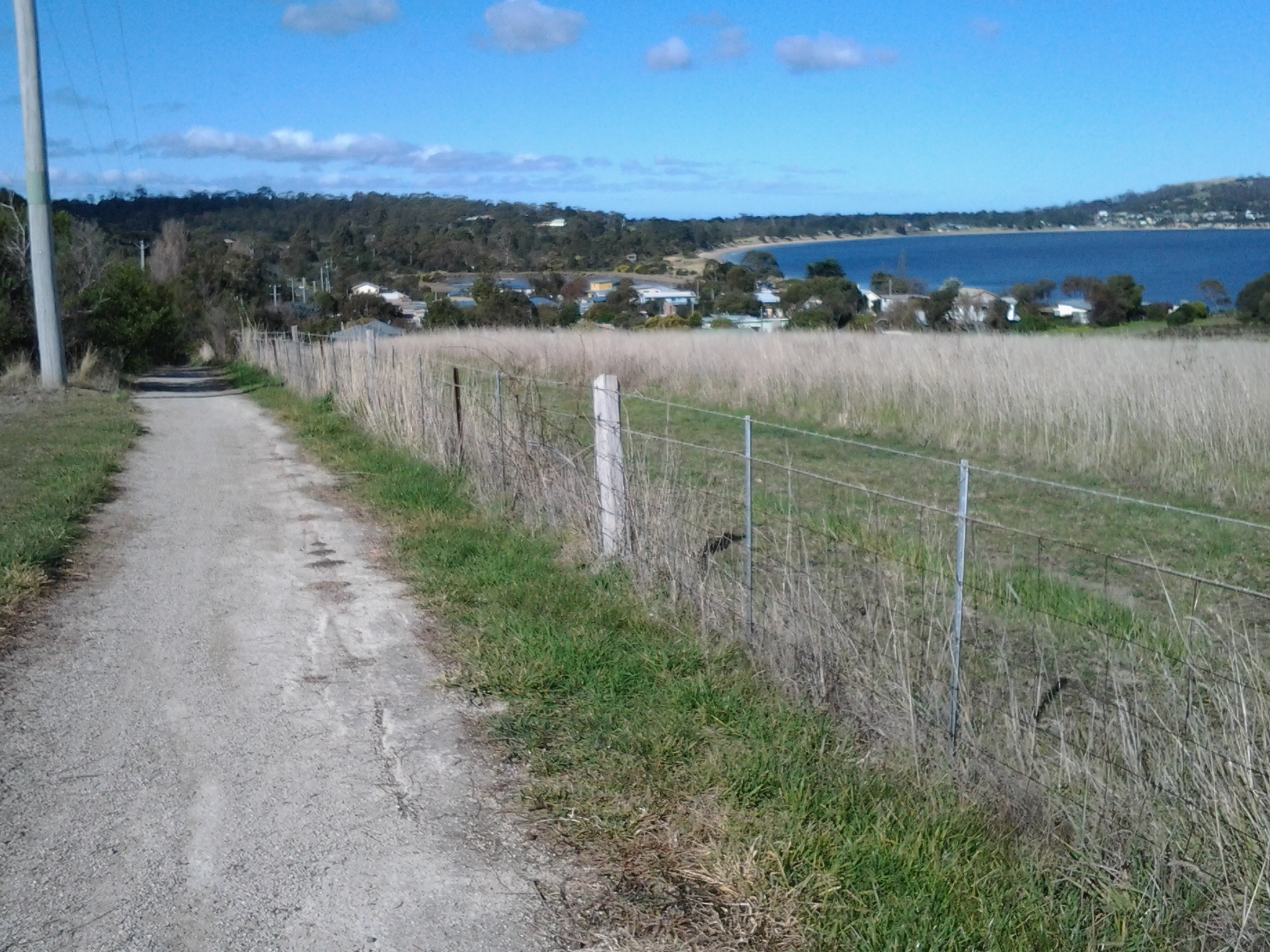
During my walk from South Arm to Opossum Bay I looked back at the long stretch of South Arm Beach. Fort Hill is above the township to the upper right.  The photo below gives some idea of the beauty of the place, and I hope it inspires others to take the walk.

 20140822_124948

This last leg took about 45 minutes. On route to the store, I passed two tourist information stands, both of which referred to this roadway being part of a convict trail, something which a team of local residents have researched (http://www.abc.net.au/news/2013-12-22/a-trail-between-south-arm-and-opossum-bay-tells-tales-of-tasman/5171434). The information which I found most interesting was that approximately 70,000 people came to Hobart on the prison and other ships between 1804 and 1853. I reflected that, of course, they all had to pass by Cape Direction, Cape Deliverance, Johns Point and the beaches on which I had been walking. It’s impossible to imagine how foreign this land of ours would have looked. And to think I started the day with trepidation!

Celebrity spotting: Brian Ritchie, once of Violent Femmes and now of MONA fame, filling up his car with fuel at the Opossum Bay store. Well I think it was him.

If you follow my walk and are in need, the public toilets are located 100 metres further along from the Opossum Bay Shop toward Opossum Bay beach.

Outside the Opossum Bay store are tables and benches, so I took the opportunity to finish my lunch. Sitting nibbling and watching people come and go occupied me until it was time to catch the bus.

22 Aug 2014 Setting out to travel to South Arm – Posting 1 of 8

The first stage of my walk along the Derwent River took me away from home for 7.5 hours. This included walking to the tip of the eastern side of the mouth of the Derwent River in the South Arm area, then gradually plodding northward on the eastern side of the river.  I am exhausted but exhilarated. When I stand on my feet or move around, my body screams ‘sit down, stay still, and never move again!’

My walk started at Bellerive when I jumped on the Metro bus No 640 that departed from Hobart at 8am. The sky was blue and cloudless but I was rugged up and beanied to avoid the early morning chill. I was nervous, and queasily excited. This felt so much like travelling into the unknown when overseas; an unknown destination (years ago Ru took me to a weekend market at South Arm, and prior to that I had driven down and back to Opossum Bay – but I have never spent time in or explored the area), unknown bus stops and reliability of timetables, new maps, unknown people and circumstances, and no idea how long it would take me to cover the stage I had planned.  The return bus was leaving Opossum Bay at 2.02pm and the next one wasn’t leaving until 5.55pm. I wanted to time my walk to catch the earlier rather than the later bus because I knew my feet wouldn’t last long. I calmed myself with the realisation, that unlike the situation with most of my travels, I had a mobile phone and sufficient funds for a taxi if need be.

Nothing I imagined turned out to be.

I had thought there would be no one on the bus because everyone would be heading towards Hobart.  Of course, this was a dopey idea. But I was the only passenger from Lauderdale onwards as the bus sped along the uneven bitumen rattling strongly (these buses are not designed for nonurban areas).

What did I see during the bus trip? Peak hour traffic streaming towards the city. The Bridgewater Jerry steaming down the Derwent to the sea. The early morning sun in the driver’s eyes. Hard winter sun on the new growth on gum trees.  Yellow floral masses on wattle trees.  Dew still sparkling on wet grass. Rare smoke trails from occasional chimneys.  Sheep, horses, llamas, billy goats, olive trees and small house orchards. It was a simply gorgeous day to behold.

The bus route deviated through the back streets of Rokeby, a tiny suburb still 30 kilometres from Opossum Bay. From the upper streets the blue flat glittering expanse of Ralph’s Bay (which is fed by the Derwent River) was stunning.

Acknowledgement of Country – to the Moomairremener people

I will be walking on the land of the Moomairremener people as I walk along the eastern side of the Derwent River.  Therefore, 

“I acknowledge and pay respect to the Tasmanian Aboriginal community as the traditional and original owners and continuing custodians of this land.”

The first people to live in Clarence were the Moomairremener, a band of the Oyster Bay tribe. Their home was all of present-day Clarence as well as Pittwater. In summer the Moomairremener went up the Derwent to the New Norfolk area to hunt, while the people there came down to the coast. In autumn they returned to the coast. Europeans later recorded some Aboriginal place names: More.der.tine.ner and Reemere were South Arm, Trum.mer.ner pine.ne was Droughty Point, Nannyeleebata was Rokeby, Mole.he.ac Kangaroo Bluff, Lore.by.larner was Betsey Island, and Ray.ghe.py.er.ren.ne was one name for the Derwent River. The Moomairremener people continued their usual life in Clarence until 1803. (http://www.ccc.tas.gov.au/webdata/resources/files/FINALClarence_01_to_1805.pdf)

Planning the first walk

Thanks to Je I was reminded that the grid on a map represents a distance and so, before I started fancifully imagining huge distances could be covered in a single leap, I have slowed down and thought through what is possible. And also what is desirable considering public transport times.

I have made the decision to start on my side of the river, the eastern shore of the Derwent. While stages along the river might be taken in any order, making a start on this epic journey at a key point seemed like the proper thing to do. I will start at the mouth of the river.  I am sure my decision as to where the mouth of the Derwent river starts will be controversial. But this is my walk. My Derwent River walk. Having consulted the maps, I can start where I think it is appropriate.

Previously I have remarked that all walks must be able to connect with public bus services – I don’t own a car, and I realise other future walkers of the Derwent might want to travel without worrying about car ferrying to get them to start and finish points. I accept the bus timetables may limit my possibilities and that I may need to walk additional kilometres simply to reach starting points, or after a finishing point along the Derwent. However, I know I will see and experience additional wonders that someone travelling in a car might miss.

Tomorrow morning the 8.09 Opossum Bay Metro bus from the Eastlands bus stop will convey me to South Arm where I plan to follow the Fort Direction road and continue on to Cape Direction.The Cape will be the starting point of my walk along the eastern side of the Derwent River. Tomorrow’s walk is a study in getting a feel for the time it takes to cover territory in a plodding easy way. It will also give me an indication of the reliability of the State Government maps. I expect to cover about 6-7 kilometres including historical sites, but only a portion of that will be along the Derwent.  This area is serviced by an infrequent bus run and I am aware that I need to be back at a bus stop for the next bus departing Opossum Bay at 2.02 pm.

Today is bright and sunny with that gorgeous cloud free Spring look. I am sorry that I hadn’t planned to start walking today. But my excitement is now building for the start of this epic adventure tomorrow!

A new idea – starting out

A year or so ago, I read the true story of an English man who walked the length of the Thames River in England. He did not start one day at one end and continue walking until he reached the other end. Instead the walker fitted many stages of the walk around his normal working life. Through his eyes, and via his words on the page, I discovered a new way of seeing and understanding the everyday world one step at a time.

Half a world away in Hobart Tasmania Australia, the mighty river Derwent wends its way from further north moving south over approximately 249 kilometres past Hobart towards the sea. Last weekend, I realised that if I could walk the edges of the Derwent, then a wonderful adventure might unfold.

As I reread the above, my writing seemed unimpassioned and lacking the excitement I feel about this idea.  How fabulous to walk along our wonderful river with all its changing temperaments and colours; on some days to walk beside its ruffled surface or its mirror sheen. To look across at parts of the city, the hills and the mountain.  To enjoy the bobbing and sails of the yachts. To be reminded that I live in this marvellous place.

And when I walk, I want to share my discoveries. I will write the story of the walk firstly on a blog followed by a later publication in a hard copy format – complete with photos.  In addition, I will align the walk with the various set down and pick up points of commuter buses of the public transport system. In this way, I will make the walks accessible for anyone without a car.

Alive with the idea, I alerted Ju and Jo. I knew they would contribute valuable information. Already the ideas are flowing.  Immediately, Ju expected to walk some stages with me – an obvious and appropriate response.  I expect other friends may wish to join some stages.

It is unlikely the stages will be walked sequentially. Rather we agreed that I should buy detailed maps on which to mark out the length and track of distinct stages. Then, depending on the weather of a day or my mood, I can select the stage that best meets the situation.  Stages will not last more than a day, but the length of any stage may vary. In winter a stage may last a few hours.  However, during the long days of summer, a stage may last many hours.

The walks will not always be on the rocky or sandy foreshores of the Derwent river. Sometimes these river edges may be place for our footfalls. At other times we may cross grassy slopes over hills or pass along the concrete pavements or bitumen roads of suburban streets. On occasion, permissions may be needed to pass through private land.  But such possibilities are ahead.

Each walk will be an incremental path through unknowns. Only once the length on both sides of the river has been covered on foot, can the patchwork of stages be brought together and moulded to tell a story.

Today I purchased five maps: New Norfolk (5026); Richmond (5226), Hobart (5225), Taroona (5224) and Blackmans Bay (5223). Collectively these cover a small part of the length of the Derwent river.  The initial aim will be to determine the walks from the sea ends of the river at a point in the Blackmans Bay suburb (on the western side) and near the township of Opossum Bay (on the eastern side) then continuing upriver and finishing at some point in the vicinity of New Norfolk.  Further west then north some of the river flows through untracked wilderness so that serious bushwalking plans will need to be developed for those distances.  The aim is to walk the most easily accessible bits first.

A wind ruffled Derwent River shows off the the pleasures of the water. being overlooked by snowcapped Mount Wellington

A wind ruffled Derwent River shows off the the pleasures of the water. being overlooked by snowcapped Mount Wellington