Tag Archives: Cluny Lagoon

Tackling the Derwent in the Meadowbank Lake region

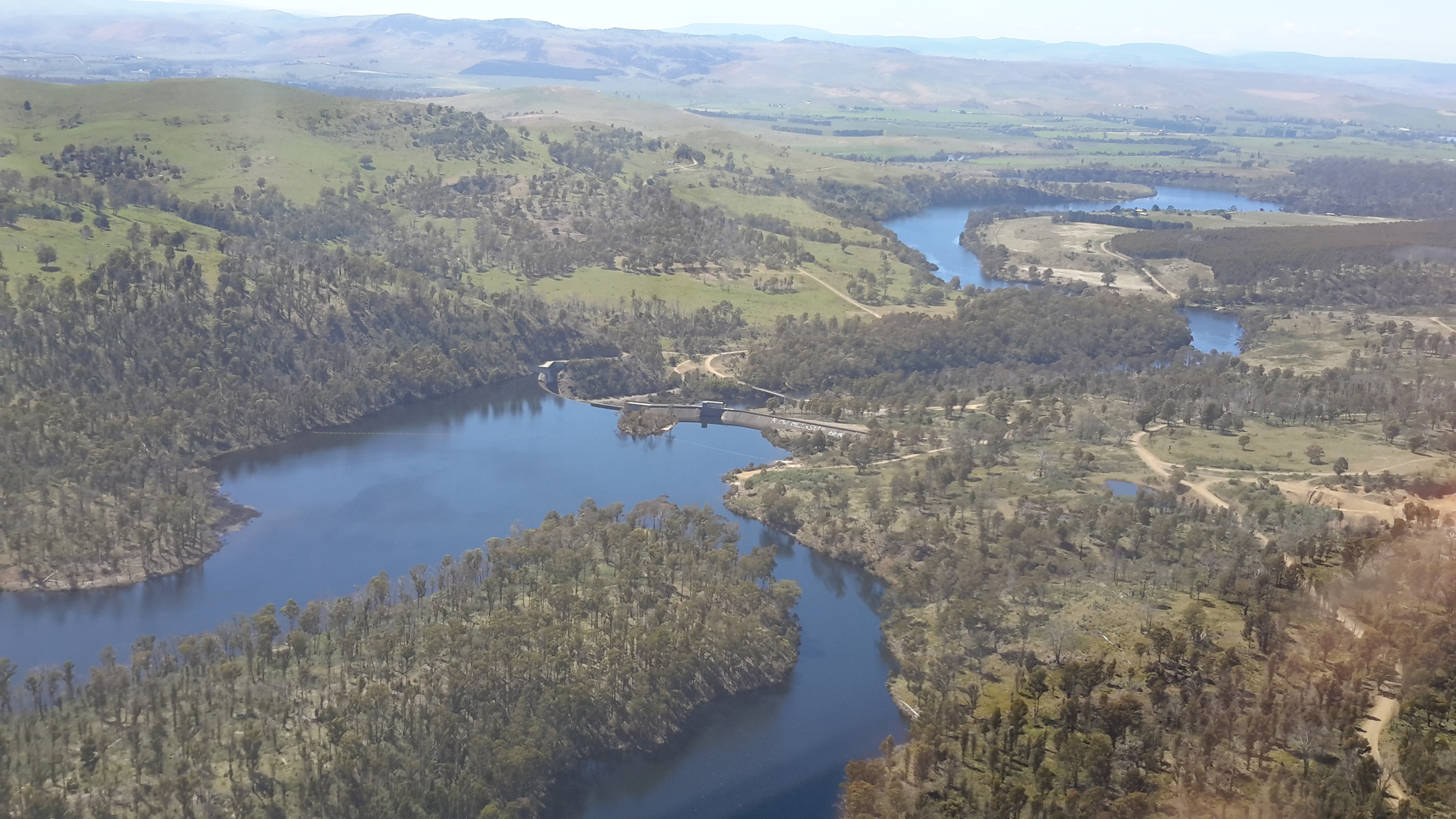
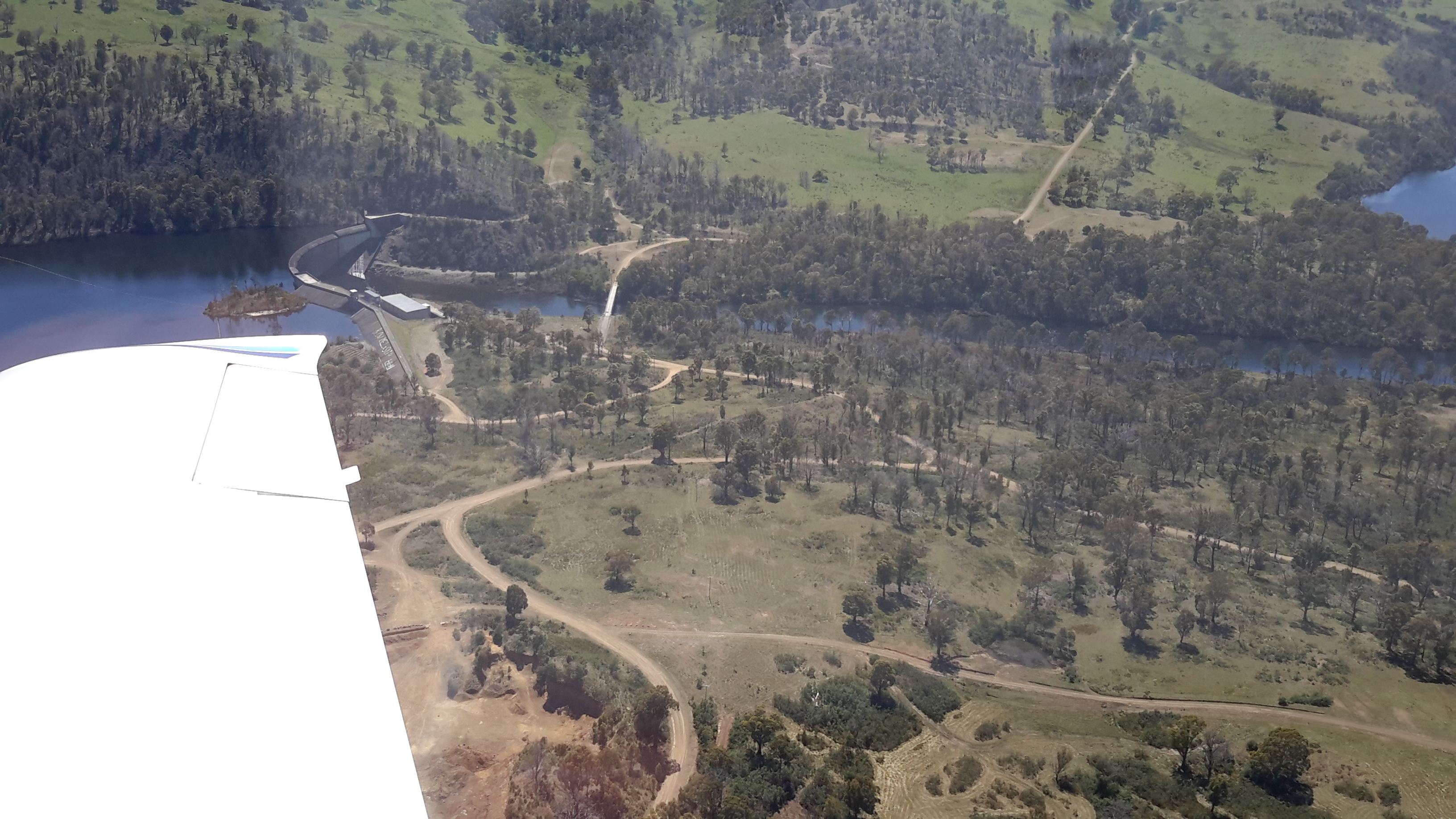
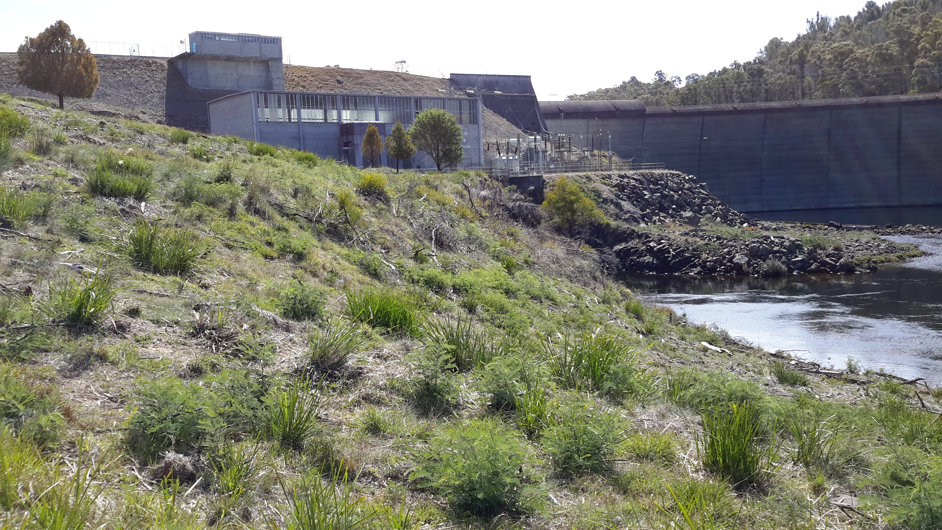
Meadowbank Lake, which backs up behind Meadowbank Dam and its Power Station, is approximately 15 kms long. Downstream, the Derwent River snakes its way through the landscape for about 23 kms until it passes Gretna and heads on towards the sea.  Upstream, after approximately 9 to 10 kms, the Derwent River finishes at Cluny Dam.  The Cluny Lagoon which extends to Lake Repulse Dam extends a further 4 kms.

To walk the Derwent between Lake Repulse Dam and Gretna is not straightforward because some private property owners cannot afford to let strangers on their property for insurance reasons, or their granted permission is a one off special case for me.  As a result, I have walked and will walk sometimes on the western and sometimes on the eastern side of the River and Lake, but I will not be providing a map and location details in my blog.  In this way I will protect the privacy of landowners, and respect the privilege their permission to access their property has given me.

I expect to tackle parts of the area on a total of 6 or 7 separate days. On each of these walks there will be a considerable amount of retracing of steps and walking away from the river/lake in order to reach roads where friends can collect me. For most of this area, public transport will either be absent or a great distance away.  Only the walk between Cluny and Lake Repulse Dams offers a reasonable amount of public access.

To date, I have walked a few sections, but I am not sure how to write up this Meadowbank area considering the confidentiality and privacy agreements I have made.  Once I have started moving west of Lake Repulse Dam and all the walks in the Meadowbank area are complete, then I will create one or more blogs that introduce at least some of the wonders of that environment.

Lake Repulse Dam

Lake Repulse Map

Looking inland, Michelle’s photo shows the Lake Repulse Dam wall backed by Lake Repulse, with Cluny Lagoon in the foreground.

PA280087 Repulse dam.JPG

Looking towards Hobart, my aerial photo below shows Lake Repulse, the Repulse Dam and then Cluny Lagoon in the distance.

20151028_114913

Chantale’s photo provides an excellent overhead view of the Lake Repulse Dam. The photo also gives walkers an indication of the challenges which the landscape offers beside Lake Repulse.

IMG_3893Repulse Dam.JPG

For vehicle drivers, the Dam is reached by heading westward past the Ouse township, turning off the Lyell Highway and travelling down Lake Repulse Road. Aerial views show the roads at the Dam site clearly.

20151028_114858.jpg

The road continues across the Derwent River below Repulse Dam giving you an excellent opportunity for a close look at the structure.

20151029_151244

20151029_151355.jpg

The western end of Cluny Lagoon, located a little downstream from the Repulse Dam, is stunning.

20151029_151317.jpg

To walk further inland around the Dam wall and then along the edge of Lake Repulse, the following photograph gives an indication of the landscape to be encountered.

20151029_151400.jpg

Michelle’s photo below shows part of the 8 km long Lake Repulse is a handsome water storage area.

PA280088Lake repulse.JPG

Historical information can be read, although I cannot vouch for the accuracy of the information.  Hydro Tasmania provides details and adds a technical fact sheet.

Cluny Dam

Cluny Dam holds back the water of Cluny Lagoon.  Compared to other dam walls and other lagoons on the Derwent River, these are comparatively small.  The Cluny Dam wall is easily accessible by driving from the Lyell Highway down Lake Repulse Road and then making a left hand turn onto a road which takes you to the water.

20151029_155825.jpg 20151029_160029.jpg

20151029_160115.jpg

The westward end of the Lagoon finishes slightly east of Lake Repulse Dam further upstream.  Parts of the shore line are open forested and there are no walking challenges heading westward around the Lagoon, if you walk on the northern side (the side you arrive at from the Lyell Highway).  The river distance covered between Cluny and Lake Repulse Dams is a mere 4 kms.  Private property and creeks will make the southern side less accessible for walking.

Michelle’s aerial photo shows the beautiful Cluny Lagoon. The Cluny Dam Power Station structure is roughly  located in the middle of the photograph.

PA280086Cluny dam and lagoon.JPG

Chantale’s aerial photo shows the Cluny Dam.

IMG_3895Cluny dam.JPG

This is an extremely picturesque part of the world and one that is easily accessible by car for blog followers who want to take a picnic and enjoy the scenery.

Hydro Tasmania offers a technical factsheet about Cluny Power Station.

The euphoria continues

Yesterday a friend An drove me up along the Derwent River where we stopped off at a few dams, power stations and lakes. I was studying the terrain at ground level (our most recent Service Tasmania maps are aged and Google Earth photos are not current either), seeing where forestry and hydro tracks existed and determining where I will need to make my way through bush ‘with walls’. I can see a line of fiction here – turning an almost impassable density of bush into a character (an evil character – even though the bush is sublimely beautiful and bountiful) that has to be overcome.  My strategy will be as always, one slow step at a time and then the bush won’t even know I have come and gone (although my muscles will).

I walked some small sections yesterday, but I won’t write them up until I have walked in the areas westwards from Gretna to those sections.  I know now that it is difficult for some local readers to understand where I have been and therefore, if I change the blog posts from being a chronological record, it may be even more unclear.  Besides, by writing the stories in order and finishing with the last walk to the source it will be clear I have walked the Derwent.

Yesterday explorations and walks were as uplifting as the previous day’s flight; it was as equally wonderful, just different.  I feel gushy with delight when I am in the bush on a blue sky day, with no wind, and with a temp that rises sufficiently but not so that I boil.  Once I am sitting on rocks in the river bed with my lunch, listening to the birds, and sensing the spirit of the place, my life feels so right.  This is the place for me.

Then, despite the day’s experiences already being a treat, life added a new wonderful surprise.  Recently one of my blog followers, Justy, alerted me to the fact she and her partner were engaged in creating a new work of art for GASP beside the Derwent River at Glenorchy, a city in the Greater Hobart Area.  As part of their project, they had already walked along the Derwent River in Cumbria, England and now were planning to walk from the sea to the source of the Derwent early next year.  I hadn’t met them and only communicated a few times by email.  But yesterday, as An drove me towards Cluny Dam, I saw two women step from their car.  I waved and smiled as you do on a country road. As we drove on, I said to An “I bet they’re the two women who are engaged in the GASP project, out conducting a reconnaissance trip”. There was no reason to believe this except I felt I knew it to be the truth (the bush works its miracles). Nevertheless we continued on and had parked near the northern end of Cluny Lagoon when the two women drove past us. Again we waved. On a later road we found ourselves coming towards each other from opposite directions, so An waved them to a stop. The women looked at us queryingly. “Are either of you Justy or Margaret? we asked.” “Yes”, they responded. Instantly I called out, “I’m Helen”.  Their nod of acknowledgement followed. And then we all poured out of our cars, and hugged and had a lively chat standing on a dusty road in strong Spring sunlight. It was a brilliant unexpected meeting and capped off what had been a day of immense discovery and pleasure.

Best wishes for your project Justy and Margaret!

From the sea to the source; stories of a river on the other side of the globe

Two years ago, Helen Ivison published River Derwent: From Sea to Source (Amberley Publishing).

 Ivison River Derwent

 The promotional puff declares this book ‘brings to light tales and stories of fascinating events, landmarks and people. River Derwent: From Sea to Source is essential reading for anyone who knows this river well, and also for those who are visiting the River Derwent for the first time.’  But what is the author referring to?

Hers is the Derwent River in the Cumbrian region of England which flows from the mountainous Lakes District in two strands, one of which starts near Styhead Tarn. The two strands meet at Grains Gill, and continue in a north easterly direction as a single river towards an expanse known as Derwent Water. The river passes through this ‘lake’ then eases into a north westerly direction across country before flowing onwards through Bassenthwaite Lake. Finally, the English Derwent River turns westwards and empties into the Irish Sea.

By contrast Tasmania’s Derwent River flows generally in a south easterly direction from Lake St Clair, through steep narrow gorges, curving around farmlands, before passing between the two sides of the Greater Hobart Area into Storm Bay. The man-made lakes of Lake King William, Wayatinah Lagoon, Lake Catagunya, Lake Repulse, Cluny Lagoon and Meadowbank Lake all disrupt the progress of the River. These lakes have resulted from dam building as part of hydro-electricity generating projects over the past century.