Tag Archives: Crayfish Point

Geological and Social History of our Alum Cliffs

Patricia Roberts-Thompson (http://taroona.tas.au/assets/document/1354363720-a_walk_along_alum_cliffs.pdf) indicates that the first recorded reference to the Alum Cliffs was in 1847.  She explains that these rocks, Permian mudstone (250 million years old, contain iron pyrites and, as the rock weathers, the pyrite oxidises and produces sulphuric acid which reacts with the limey clay to produce alum. Roberts-Thompson could find no evidence that the alum has been extracted from our cliffs for commercial purposes.

Simon Stephen’s research (http://taroona.tas.au/assets/document/1352547986-geology_reduced.pdf) is in sync with that of Patricia Roberts-Thompson  when he says the mudstone on the Alum Cliffs contains much sulphur so that when struck a strong smell is emitted. “Much of the sulphur manifests itself as a white encrustation on thee sheltered areas of the cliffs. It has a distinct bitter taste…”  (Trust me – I won’t be taking a bite or licking it). Stephen’s article is exceptionally interesting not the least because it pin points a geological fault line which is near Crayfish Point (where I have already walked) and which extends out through the end of Hinsby Beach and then under the water along the Alum Cliffs.  I don’t know if any seismological activity has occurred in my life time there nor whether any is expected. I’d rather nothing happened during my forthcoming Stage 12 walk along the Alum Cliffs.

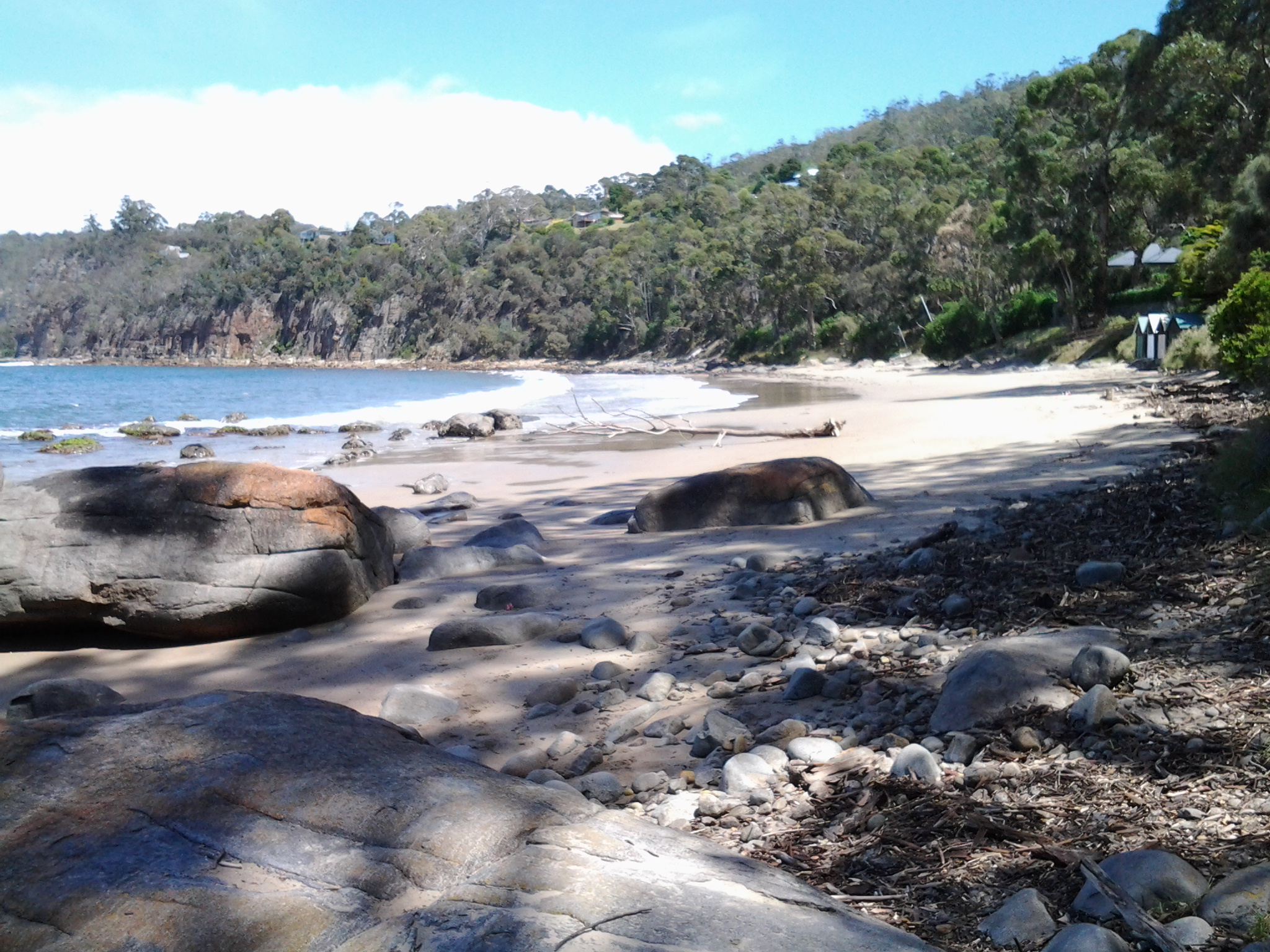
The Kingborough Council distributes a brochure with the following information: “The route followed by today’s Alum Cliffs Track has long been a coastal path used by local people. In 1988 it was formally developed as part of Australia’s Bicentennial celebrations. In more recent years, Council has upgraded the southern section of the track, which climbs from Tyndall Beach through coastal blue gum forest with tall silver banksias. The track then winds up through silver peppermint bushland, dips into a glorious fern filled gully, before rising again onto headlands for commanding views over Storm Bay and the Derwent Estuary. A new start to the track without steps has now been constructed above Tyndall Beach to make the track accessible to more users. The Alum Cliffs are so named because alum – a compound used in dyeing, tanning and medicinal products – is found in the cliffs.”

It is a shame that all instructions to reach and walk the Alum Cliffs use Kingston Beach in the south as the base to walk north and then return. Websites provide information about multiple entrances along the route at Tyndall Rd, Harpers Rd, Taronga Rd.  Apparently a Metro bus stop is located 100m south of the intersection of Taronga Rd and Channel Highway. I wonder how many people have walked the Alum Cliffs Track from the northern end and, if not, like me would like to read advice about how to tackle the cliffs departing from Hinsby Beach.

20150119_131327

It may be that, on Stage 12, I will start out at the end of the Hinsby Beach and then be forced to retrace my steps, return to the Channel Highway and walk up the winding fairly narrow Highway with no pedestrian walkway until I reach the Brickfields Track. From http://www.greaterhobarttrails.com.au/track/brickfields-track I understand that “the Brickfields Track links between Taronga Rd (adjacent to the Channel Highway) in Bonnet Hill and links to the Alum Cliffs Track. The route of the Brickfields Track takes you through the historic remains of the brick-making area; part of the nearby and short lived 1840’s convict probation station. The track is a mix of narrow bush track and timber boardwalk with some steps along the route.”

Taroona’s coastline as experienced on Stage 11 of my walk along the Derwent River

The last leg of this Stage was the most interesting because I made discoveries which delighted me deeply.

At 12.18pm, I left my Channel Highway resting spot and walked downhill toward the people-free Taroona High School (closed for school holidays). Close to the bottom of the hill I could see the tops of boathouses and a ‘beach’ to my right so I took a dogleg to Melinga Place on my right and continued downhill.

20150119_122623

I didn’t know this existed. Mostly a rocky shore, a little sand, edged by a mown green lawn.  Serene.  Across the Derwent River, I could see Gellibrand Point at the north of the South Arm peninsula.

20150119_122608

Walking southwards it wasn’t long before I entered the foreshore bushland on an easy-to-walk dirt track.

20150119_122632 20150119_123039

Later I found this had a name: the Taroona Foreshore Track. At one point the ‘track’ passed over a ‘beach’ of shells and rocks then returned to dirt and rose up over areas raised above the water.

20150119_123407 20150119_123610

An onshore breeze kept me moving.  Every so often, steep trails descended to the rocky shore but I realised that staying on the track would be more comfortable than rock hopping the edge of the River.

When I walked through a grove of trees that were obviously different, I was delighted to read an information panel which informed me this was an “unusual and isolated stand of blackwoods.  Acacia melanoxylon.”  The species is also known as Sally wattle, lightwood, hickory, mudgerabah, Tasmanian blackwood or black wattle. Their rough bark seemed as if it would flake off in small pieces but it was toughly attached.

20150119_124053 20150119_124059

At 12.46pm I looked back northward and could still see the boathouses near the High School.

Looking back to boathouses below Taroona HS

A couple of minutes later I reached Crayfish Point where I noticed craypot markers bobbing in the Derwent River as evidence that fishing for crayfish/lobster was taking place.  However, a sign seemed to indicate this was part of fisheries research by the University of Tasmania.

20150119_124945

Brilliant orange lichen sprawled across some of the rocks.  Huge Pied Cormorants rested on rocks with water lapping at their feet.  This was one of those brilliant days when all the superlatives in the world seem inadequate.

It was near here that an information panel enlightened me about some of the native vegetation.  Now I can identify not only Pigface which I love, but also Bower Spinach and Grey Saltbush. Why I didn’t take photos of the real thing while I was walking I cannot say. Daft!  So I have Googled for images:  If you type in Bower Spinach Tasmania Images, up comes a suite of pictures showing this fleshy leaved plant.  Try something similar to find images of the softly grey coloured Grey Saltbush.

When I reached the start of Taroona Beach at 12.53pm, I looked up the hill and in the distance I could see the Shot Tower that had been built in 1870 (the Shot Tower, a major tourist attraction, is normally accessible from the Channel Highway).

The Batchelor’s Grave Historic Site, just above the foreshore of Taroona Beach, was a surprise.  Wikipedia provides the information that this is “the grave of a young sailor, Joseph Batchelor, who died on the sailing ship Venus in the Derwent Estuary in 1810, and was buried ashore on 28 January 1810. It is reputed to be the oldest European grave in Tasmania”. I am amazed at this idea.  I cannot imagine that many Europeans didn’t die and were buried in Van Diemens Land before 1810 – however, maybe this is the only stone grave marker left from early in the 19th century.

20150119_125452 20150119_125441

Taroona Beach is backed by Taroona Park with pleasant picnicking facilities and public toilets.

20150119_125327 20150119_125918

I left at 1.06pm and walked along Niree Parade for a couple of minutes until the Taroona Foreshore Track restarted.

Within moments I arrived at Hinsby Beach, which was the find of the day as far as I am concerned. Isolated.  Small.  Tree edged. Calm.  Small wave break.  A few boathouses.  A family beach with a few swimmers and sun bathers.  Located at the end of the River edge before the steep Alum Cliffs which flow for 3 or four kilometres to Kingston.

20150119_131323 20150119_131402

I soaked in the atmosphere before starting uphill on a public access walkway at 1.22pm, under shady bushes with lush surrounding ground cover. The track connected to the bottom of Hinsby Road. At the top of Hinsby Road the Channel Highway flowed by. As I arrived at bus stop 30 at 1.36pm, a Metro bus came by on which I made the trip back into Hobart. Half an hour later I was in the city and ready to make the bus trip back home in Bellerive.  I walked in the door at 2.40pm after an exhilarating day when my feet didn’t want to carry me, but I insisted and they persisted. This really is a wonderful part of the world.