Tag Archives: Westralian

Into and through the suburb of Otago Bay – part of the 7th stage of my walk along the Derwent River

Before long I could see the water of Otago Bay, and I could see the rusty remnants of the two boats, the Otago and the Westralian. In the photo below, the low mountain on the other side of the Derwent is Mount Faulkner.

20141031_102131

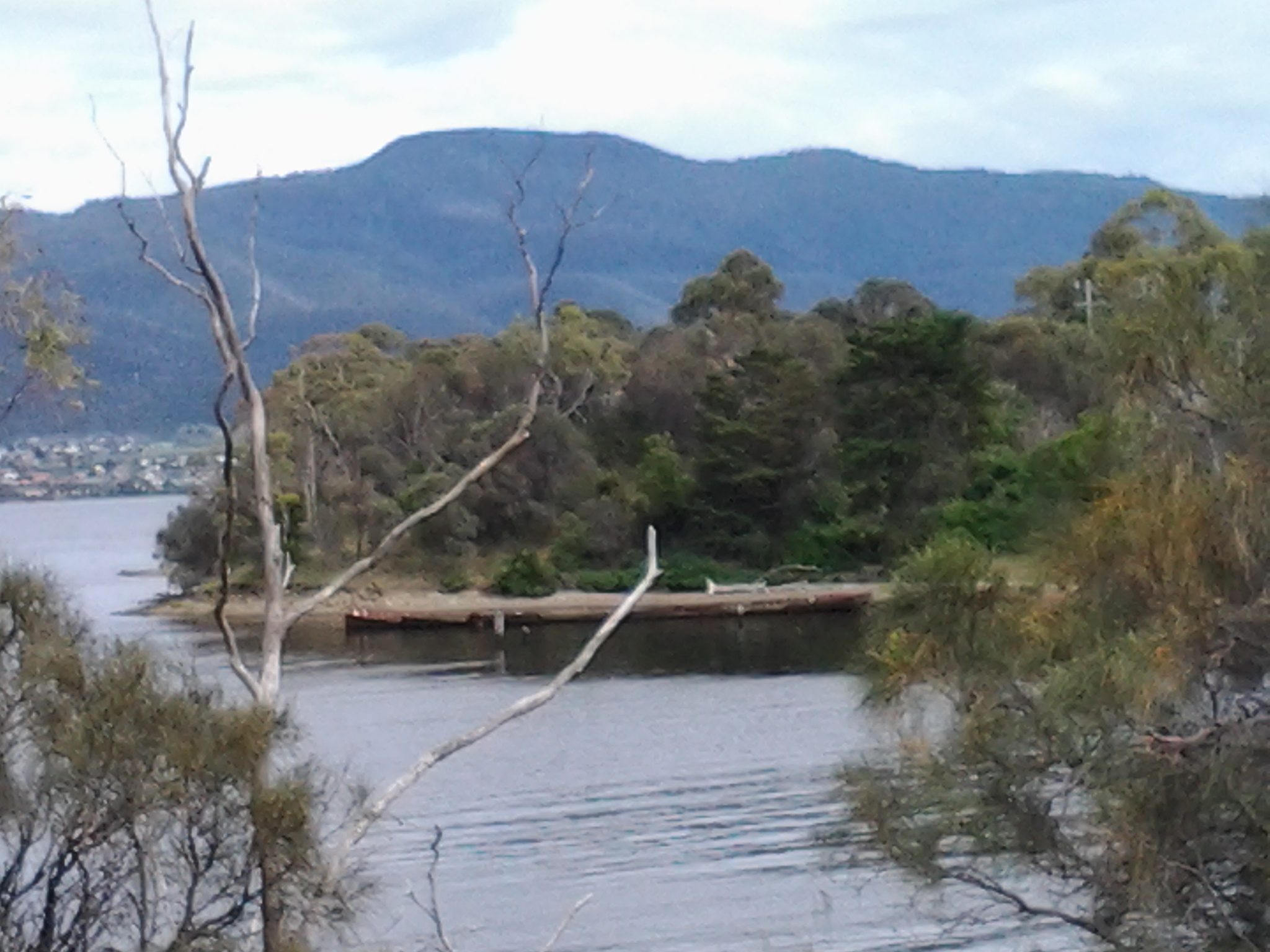
Ja and her dog were lively company and walking with her was a big change from my normal solo experiences. We enjoyed photographing each other in this quiet and peaceful place and parted once we reached the interpretative panel near the sunken ribs of the two boats (Westralian on the left and Otago on the right in the photo below).

20141031_104822

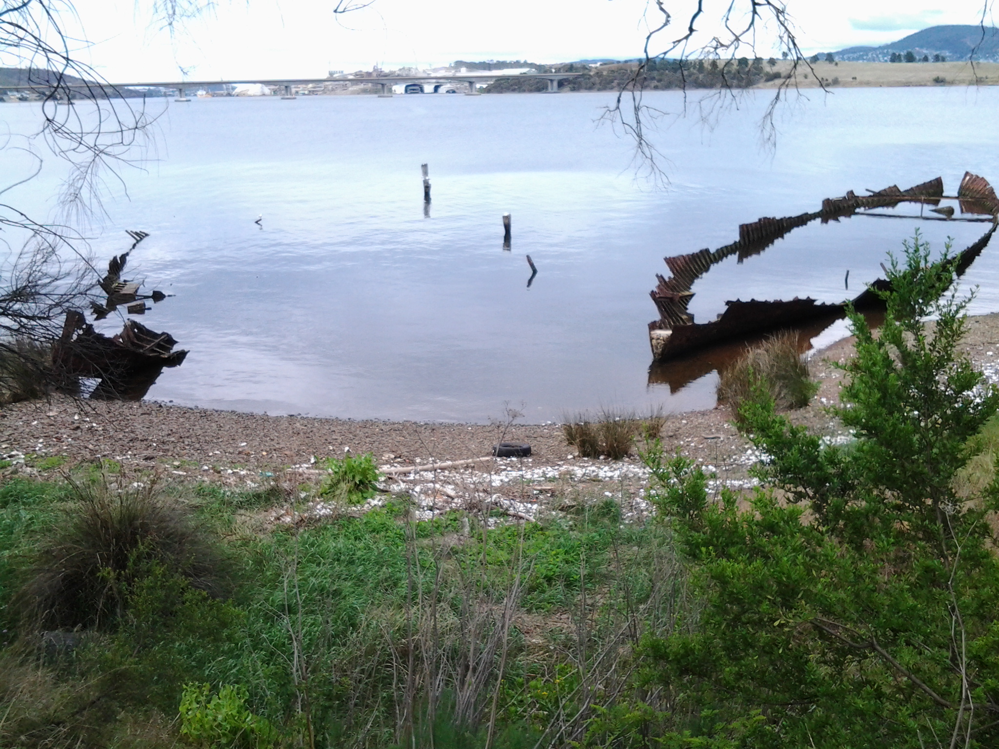
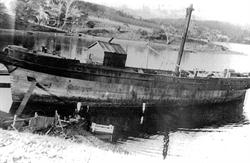
I was disappointed that the main point of the interpretative panel was not to talk broadly about the history of both boats but to laud the last Captain of the Otago, the esteemed novelist Joseph Conrad.  Over the road, Conrad Drive wound up the hill into a residential area. It seems the author has become most important.  The Westralian is not mentioned at all so I can only imagine other visitors must leave the site quite puzzled about what they are seeing. In an earlier posting I provided detailed information about the Otago, after which the Bay and suburb have been named. The Westralian was a steam ship abandoned and cut down during the 1930s.

It was 10.40am before I left the boats of Otago Bay. I walked uphill – yet again without a formal pathway so I was alert for cars travelling through. There are always ‘lead foot Larrys’ whose press on the car’s accelerator speeds them through the suburban streets as they veer unexpectedly onto whichever side of the road gives them the shortest path to whatever their destination.  Could be a shortcut to God if they are not careful.

This leafy gum-treed suburb is mostly high above the Derwent River and many of the houses sit with grand views. At one point I could see that I was level with the height of the Bowen Bridge in the distance.  It was not possible to walk around the water’s edge and it was impossible to walk around the edge of the cliffs because access to these has been cut off by the gates and fences of private property.

I stayed walking up and down and then up and then downhill on undulating Otago Bay Road.

20141031_110555

Some houses were located on 5 acre lots. Some parts of the suburb seemed quite rural without any sign of active agricultural businesses. I passed a creek with croaking frogs and others making a soft booming bom bom, bom bom; a repetitive but very musical sound. Wild blackberry canes flourished. Sulphur crested cockatoos screamed through the trees. The sounds of so many other birds reverberated through the bush. Beautiful. Wonderful.

At 11.10am, I noted a left hand road led to accommodation; the Penenjou Bed and Breakfast. I didn’t walk this road but I imagine that tourists staying out here might find the country to be very attractive and peaceful.  Apparently the homestead is located on a hectare of developed gardens overlooking Mount Wellington.

I continued walking along Otago Bay Road, close to and parallel to the Highway.

At the intersection with Restdown Drive reached at 11.18am, a sign pointed to another accommodation option Otago Cottage (http://www.otagocottage.com.au/). Again, knowing this was a No Through Road, I stayed walking along Otago Bay Road.

Looking inland I could see the smallish mound of Mount Direction.  From experience I know that walking tracks on this mountain can be accessed from the Risdon Dam Reserve near to the Prison and Willow Tavern, way back near Risdon Cove.

20141031_111945

I reconnected with the East Derwent Highway at 11.22am, edged the road dodging rain spits, and continued walking northwards.

20141031_111957  20141031_111951

How common is the name Otago and what is its history?

How did Tasmania come to name its Otago Bay, one of the suburbs in the broader Old Beach area, on my planned Stage 7 of the walk along the Derwent River?

On the Clarence City Council site at http://www.ccc.tas.gov.au/page.aspx?u=1085, Otago Bay was named after the iron barque the Otago, the remains of which can still be seen on the shoreline of Otago Bay. Wikipedia reports that the remains of the Otago (beached in the Bay in 1931) and a steel river steamer the Westralian (beached in 1937) can both still be seen on the beach. The Otago was dismantled at a shipbreaking establishment that operated at the Bay between the 1920s and 1960s. Some excellent current photos of the remains of the Otago can be seen on http://pacific-edge.info/2014/01/otago/.  I look forward to clicking my own photographs later this week.

At http://www.nzgeographic.co.nz/archives/issue-78/joseph-conrads-ship, I learned the Otago was commissioned by Captain Angus Cameron and built by Alexander Stephen & Sons, Glasgow, Scotland. Once in Australasian waters, the Otago was used as a regular carrier of coal from Newcastle, New South Wales Australia to New Zealand’s city of Dunedin in the early 1870s.

The Otago page on the Parks and Wildlife Service website http://www.parks.tas.gov.au/index.aspx?base=1793 explained that the Otago was a three masted ship built in 1869. In 1872 the barque was transferred from Glasgow to Adelaide, South Australia. The Otago‘s chief claim to fame is that the vessel was the only command of the famous Joseph Conrad during 1888-9 (Conrad became a well-known novelist using some of his mariner experiences, after he gave up sea faring in the mid-1890s).

The vessel arrived at Hobart in July 1905. In January 1931 the Otago was sold to a local shipbreaker and towed to its present location in Otago Bay. The hulk was partially dismantled for scrap metal in 1937 and more completely in 1957. The bow of the vessel rests on the shoreline with the stern lying in approximately two metres of water. The iron hull has been cut back to the waterline and the bow and stern have disappeared entirely. The remains can easily viewed from the shore as the interior of the hull and the surrounding area contain a quantity of debris that make closer examination hazardous. The photo below, of the Otago, is from the parks and wildlife website.

Otago 1900 Adelaide

The Otago at Port Adelaide, c.1900 (in the collection of the Archives Office of Tasmania)

The photo below, dated a decade later, is also from the collection of the Archives Office of Tasmania.

Hulk Otago 1910

Hulk of the Otago, c.1910

That is all well and good. We know our Otago Bay was named after a boat that was dismantled in its Bay. But what does the name Otago mean?  How did the boat get its name?

Otago, a well-known region in the southern island of New Zealand, was settled by people from Scotland starting in 1848. Many people believe the name ‘Otago’ is a European corruption of the Maori word ‘Otakou’ which translates as ‘village’. It may be fitting to refer to our Otago Bay as a village because its population only numbers a few hundred and it is isolated from other suburbs by the natural landscape. However, there seems to be no connection between our Tasmanian Otago Bay and with Maori culture (although perhaps some New Zealanders live there – I don’t know).  More than one boat was built in Scotland and named Otago in the second part of the 19th century, so the impact of the Otago region in New Zealand on Scotland was significant.

The founder of the Otago settlement in New Zealand, William Cargill, died in 1860 and a Tasmanian sandstone monument to him was built in Dunedin in 1864. Why Tasmanian sandstone? According to http://freepages.genealogy.rootsweb.ancestry.com/~nzbound/otago_bdm1860.htm, son John Cargill stopped by Tasmania in 1841, before he helped his father to settle in Otago.  Did John collect some local sandstone during his visit? If so, what an extraordinary thing to do considering the Otago ship eventually had its resting place in the Derwent River.